Soil texture
- FAO at 10 km (global).
Source: http://www.fao.org/ag/agl/agll/dsmw.htm
Download:
clay_fao.hdr.gz
clay_fao.dir.gz
sand_fao.hdr.gz
sand_fao.dir.gz
- HWSD at 1 km, v1.10 (global).
Source: http://www.iiasa.ac.at/Research/LUC/External-World-soil-database/HTML/
Warning: files recently renamed. Formerly called "SAND_HWSD_MOY_v1" and "CLAY_HWSD_MOY_v1".
Download:
CLAY_HWSD_MOY_v1.10.hdr.gz
CLAY_HWSD_MOY_v1.10.dir.gz
SAND_HWSD_MOY_v1.10.hdr.gz
SAND_HWSD_MOY_v1.10.dir.gz
soc_top.dir.gz
soc_top.hdr.gz
soc_sub.dir.gz
soc_sub.hdr.gz
- HWSD at 1 km, v1.10_ECO_I (global).
In v1.10_ECO_I, maps with missing data (relative to the land/sea mask from ECOCLIMAP_I) are corrected, setting the default value 0.33 for sand and clay in missing data points. NB: for the moment the correction wasn’t performed for soc maps.
Warning: files recently renamed. Formerly called "SAND_HWSD_MOY_v2" and "CLAY_HWSD_MOY_v2".
Download:
CLAY_HWSD_MOY_v1.10_ECO_I.hdr.gz
CLAY_HWSD_MOY_v1.10_ECO_I.dir.gz
SAND_HWSD_MOY_v1.10_ECO_I.hdr.gz
SAND_HWSD_MOY_v1.10_ECO_I.dir.gz
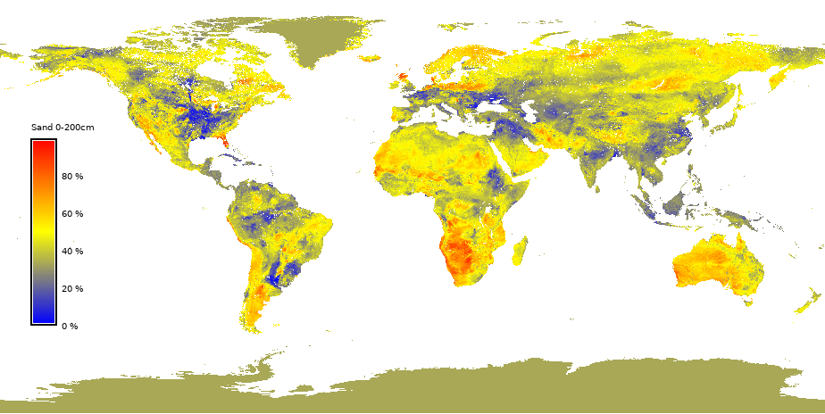
- SOILGRIDS v2.0 at 10 arc-sec resolution (~300m)
Data from SOILGRIDS 250m v2.0 Source: https://soilgrids.org/
Global data, at 10 arc-sec resolution (~300m), given in fraction by percent weight (%). For missing values (Antarctica, central greenland, some high latitude regions and urban areas) a value of 33% is applied. Visualize data for sand
Download:
clay_0-200cm_mean_int.tgz
sand_0-200cm_mean_int.tgz
Data are also available for different layers:
Warning: The currently distributed SURFEX code does not allow the use of different sand and clay fractions depending on the layer, but this will be possible in the next version of SURFEX V9.1.0.
Download:
clay_0-5cm_mean_int.tgz
sand_0-5cm_mean_int.tgz
clay_5-15cm_mean_int.tgz
sand_5-15cm_mean_int.tgz
clay_15-30cm_mean_int.tgz
sand_15-30cm_mean_int.tgz
clay_30-60cm_mean_int.tgz
sand_30-60cm_mean_int.tgz
clay_60-100cm_mean_int.tgz
sand_60-100cm_mean_int.tgz
clay_100-200cm_mean_int.tgz
sand_100-200cm_mean_int.tgz