

Accueil > Our research topics > Adaptive Observation > Impact of the increase of aircraft data in AROME-France
by Alexis Doerenbecher
published in the Météo-France 2017 Research Report (ISSN : 2116-4541)
In Europe, EUMETNET (EUropean METeorological NETwork) manages commercial aircraft data purchase and dissemination (E-AMDAR operational service). On request of Météo-France, the number of these observations was increased in France from beginning of May to mid-June 2017. More data were assimilated by Numerical Weather Prediction (NWP ) models. This E-AMDAR trial was an opportunity to check that the assimilation of additional aircraft data increases AROME -France (Météo-France limited-area model, AROME =Application of Research to Operational at Mesoscale) forecast skills. To do so, a data-denial test suite has been run (assimilation and forecasts) on May 2017. The extra data being organized in vertical profiles (ascents and descents flights) at French airports but not being flagged as “extra”.
A significant part of the work was to identify additional observations. Every profile has been associated with an airport (French or not) and was assigned with a status : “routine” or “extra” using “normal” periods such as April 2017 or May 2016 as a reference for “routine”. Suppressing all “extra” profiles yields a 15% decrease of the European aircraft data, or a 12% of all aircraft data used by the operational AROME -France (see Figure 1).
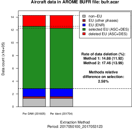
Figure 1 : This diagram shows the impact of two methods to identify “extra” profiles of E-AMDAR data (at French airports). The red part shows the amount of “extra” data removed in the data-denial experiment. The green part is made of “routine” profiles. The other E-AMDAR data (in blue and brown) are not affected by data selection. As are the data from the USA (grey) : they are not modified in the data-denial experiment.
The impact on the quality of AROME forecasts, when removing extra data on May 2017 is reduced. It is only detected at 12h and 18h networks. It is rarely significant. A slight improvement of the 24-h wind and temperature forecasts is assessed on a geographical domain that closely encircles the metropolitan area (see Figure 2).
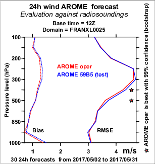
Figure 2 : Estimate of the impact of the withdrawal of additional E-AMDAR observations in AROME -France forecasts when comparing to radiosoundings. The 12Z-based 24-hour forecast bias and Root Mean Squared Error (RMSE) are shown as a function of pressure levels. 12Z is the base time that exhibits larger impacts. Here, the operational (in blue) appears slightly better than the test (in red) : lower RMSE and lower bias, between 850 and 250 hPa. The impact is significant only for 2 levels (stars) in mid-troposphere.
|