

Accueil > Our research topics > Adaptive Observation > DTS 2008 and 2009
The Data Targeting System : a test of feasibility of operational adaptive observation
The concept of guiding a component of the atmospheric in-situ observing system over Europe depending on the meteorological situation has entered a new phase : EUCOS has implemented an experimental data targeting system (DTS ) in 2008. This system aims at controlling the temporal frequency in the collection of commercial aircraft data, and activating some of European radiosoundings stations as well as some commercial ships equipped with radiosounding facilities. The DST has been developed in the predictability segment of the European project EURORISK-PREVIEW (FP6).
This system worked every day from March to December 2008, following 4 sequential steps.
Initially, on D-Day, the national weather forecasting services involved in the exercise, including Météo France in the first place, proposed to focus on a specific meteorological event (or system) to occur 3 or 4 days later. The case selection process implies the agreement with the DTS lead-user posted at the Met Office in Exeter.
In a second stage, sensitivity area computations (SAC ) were made for each identified case of that day and were edited in the form of charts (see figure). The ECMWF , the Met Office and Météo France perform these calculations. At ECMWF , the sensitivity was computed with the linear version of the prediction model and its adjoint. At the Met Office and Météo France, the results were derived from the ensemble prediction systems of each center respectively.
In a third stage, the charts were examined to determine the effective reinforcement of the observing network on day D+1. The purpose of these additional observations was to reduce the forecast error (on Day 4) on the weather event of interest (compared to the forecast that would not benefit from the additional source of information).
In a fourth stage, instructions were delivered automatically by the DTS to entities that directly manage the deployments of the observations (national weather services, airlines, etc.).
The various steps leading to the decision roughly took half a day. Météo France proposed cases very regularly and has played the role of DTS lead-user for short periods.
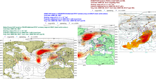
Example of sensitivity maps, as available in real time, on November 25, 2008 at midday and used to determine the location of additional observations to deploy the day after at 18h UT. The aim is the quality of weather forecast in the region bounded by the blue square 30 hours after the measurements. In this case of Novembre, we chose to follow the guidance given by the ECMWF sensitive area since it maximized the number of stations able to be activated the day after.
|