11. Malgorzata SZCZECH-GAJEWSKA : "Use of IASI / AIRS observations over land"
I. Introduction
This is the study of use of observations over land from advanced infrared sounders (with spectral resolution < 0.5 cm -1) such as IASI or AIRS. Previous work focused mainly to the data over sea. Over land the problem is the simultaneous retrieval of atmospheric profiles and of surface characteristics (land surface temperature LST and surface spectral emissivity SSE). Two basic ways of retrieval can be distinguished: joint (simultaneous) of atmospheric and surface parameters and the physical multi-spectral method. The main component of both methods consist of the usage of ancillary information which specifies SSE behaviour or constitutes some a-priori constrains. A first estimate of surface temperature can be taken from model forecast, but emissivity can be provided just by climatological values depending on the land cover type. First part of work comprised inclusion of emissivity fields for chosen spectral ranges into ARPEGE climatological files. The further study will use one-dimensional framework to test the retrieval of both profiles and surface values. Then, it will be extended to three-dimensional analysis scheme.
IASI, an Infrared Advanced Sounding Interferometer is jointly developed by EUMETSAT and CNES an will be operational instrument on the EPS-Metop series of satellites (first launch about 2005). The IASI instrument supplies the spectra of the atmosphere in the IR band, with 8461 channels in each spectrum. This gives us great advantage of treating emissivity spectra as separated into 200 cm-1 wavebands.
II. Climatology
Fields in climatological files of ARPEGE and ALADIN created by configuration 923 of models are interpolated just one time in case of defined land-sea mask and type of surface. Until this time as a surface characteristics were concerned just two fields - the albedo of bare soil and emissivity, but without annual changes. The emissivity (mean value over entire spectrum) was interpolated or calculated over the final grid as a function of surface type and the maximum fraction of vegetation. The mean values of emissivity were derived from old Navy data.
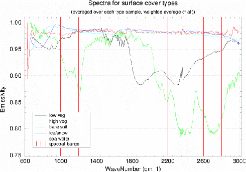
Work on the creation of new climatological fields of SSE had started with appropriate code changes and creations of new subroutines. As illustrated in Fig.1 we divided almost IASI IR range into 12 equal wavebands: from 600 cm-1 to 3000 cm -1 with step 200 cm-1 . According to them climatological fields of surface spectral emissivity were created. Thus, two approaches of creating climatological files of SSE were used, namely with and without interpolation of emissivity. First one was based on the global emissivity maps from Jean-Louis Roujean (further called as JLR). They had the resolution of 0.5° over the whole world, and were created on base of MODIS spectral library and also 0.5° resolution vegetation maps. Then, those SE maps were taken as an input for configuration 923 (modified one) in which emissivity was interpolated to final ARPEGE grid. The second way was to assign spectral emissivity values, calculated from MODIS and ASTER, to each ARPEGE gridpoint with respect to surface type, percentage of land and maximum fraction of vegetation.
Band [ cm-1 ] |
sea |
ice |
soil |
high v. |
low v. |
600 - 800 |
0.989 |
0.994 |
0.946 |
0.980 |
0.970 |
800 - 1000 |
0.980 |
0.989 |
0.880 |
0.981 |
0.982 |
1000 - 1200 |
0.979 |
0.988 |
0.976 |
0.982 |
0.986 |
1200 - 1400 |
0.981 |
0.986 |
0.984 |
0.981 |
0.973 |
1400 - 1600 |
0.982 |
0.988 |
0.978 |
0.976 |
0.923 |
1600 - 1800 |
0.979 |
0.988 |
0.964 |
0.973 |
0.896 |
1800 - 2000 |
0.977 |
0.983 |
0.882 |
0.972 |
0.897 |
2000 - 2200 |
0.976 |
0.984 |
0.829 |
0.971 |
0.899 |
2200 - 2400 |
0.974 |
0.985 |
0.853 |
0.972 |
0.934 |
2400 - 2600 |
0.970 |
0.981 |
0.843 |
0.973 |
0.949 |
2600 - 2800 |
0.965 |
0.971 |
0.920 |
0.975 |
0.962 |
2800 - 3000 |
0.965 |
0.970 |
0.907 |
0.980 |
0.960 |
Table 1. Mean spectral emissivity values for each type of land cover,
based on MODIS and ASTER data
The differences between climato-logical emissivity fields created in both ways were found joust over land covered by vegetation. They were caused by different vegetation maps usage. To be consistent with the model vegetation cover and because of the emissivity data JLR provided us were without estimation errors we have decided to use the second way of climatological files creation. As an input data for climatology were used the laboratory measured samples of emissivity for different kinds of materials. Main source if it were MODIS and ASTER spectral libraries, which contains respectively emissivities and reflectances of many kinds of materials. In Table 1 are shown the calculated spectral emissivity values (mean) for each waveband and surface type. It was very important to obtain as numerous as possible the samples for each type of land cover, because of calculating background errors for emissivity. The final samples numeration is : sea water - 5 samples, ice/snow - 9 samples, 128 samples of different kinds of soils and sands, 24 samples of high vegetation (trees) and 5 samples of low vegetation.
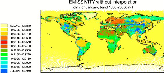
Fig.2 ARPEGE climatological field of surface spectral emissivity for the waveband 1800 - 2000 cm-1.
The emissivity values were assigned to surface and vegetation types.
The result of this work are 12 new climatological emissivity fields, with the names: SURFEMI0700.IASI, SURFEMI0900.IASI and so on, respectively to the middle values of the wavebands. Fig.2 shows the climatological map of spectral emissivity for January and waveband 1800-2000 cm-1 .
III. Background errors covariance matrix - starting point
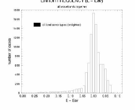
Fig. 3 Errors distribution for direct SSE
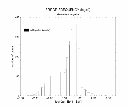
Fig. 4 Errors distribution for -log(1-SSE )
During the creation of climatological files one more problem arose, to use directly SSE or convert it to -log(1-SSE) ? The idea came from Goulven Monnier (personal communication). He found out that for the emissivities he was using (some samples from ASTER spec. lib.) distribution of -log(1-SSE) around mean value is more Gaussian than for SSE. The emissivity values in general are very close to 1, actually they are lower than 1, so such change would help for the further studies with LSE and SSE inversions. Our sample of the spectral emissivities is much bigger and it's coming from the different sources, so we couldn't assume the same behaviour of SSE - we had to check this. Appropriate tests were done, but instead of making distribution of the emissivity around it's mean values was checked the distribution of the errors (SSE-av(SSE)) around 0. First it was done for all wavebands together, but separately for each surface cover type. Results showed that the distribution of the errors almost for all surface types (except snow/ice samples) was more Gaussian for the direct SSE than for -log(1-SSE) values. Afterwards for verifying if it is in general true for all data together was prepared common sample for all types of the surface cover. The compilation of those emissivities was based on weights - importance of each surface type in global aspect. Base for it was taken from ARPEGE model. In it, each surface type covers following percentage of the globe: sea water - 53.4%, ice/snow - 1.4%, high vegetation - 13.5%, low vegetation - 29.2% and bare soil - 2.5%. The results you can see on Fig.3 and Fig.4, apparently the distribution of not transformed surface emissivity more resembles the normal one. Thus for further work direct SSE data were taken. The other reason why we were comparing the errors distributions was the fact that already we had calculated some statistics of SSE for building background error covariance matrix. Currently creation of B is in process.
IV. Plans
The closest future plans are connected with background error covariance matrix B - continuation of work with it's calculation, looking for correlations between T and Ts and also statistics for Ts (variance of error). The further work will be connected with 1d radiative-transfer model. It will comprise among others, separation of the fields for minimisation and calculation of the gradients for LST and SSE.
Appendix
| The previous ALATNET PhD and Post-Doc Studies |  |
Home | The next ALATNET PhD and Post-Doc Studies |