
1. In Austria
Experiments on MAP cases
To investigate the problems of NWP precipitation forecast over mountainous areas, two ALADIN model simulations with different model resolutions and dynamics were carried out: a) 9.6 km horizontal resolution, hydrostatic; b) 4 km horizontal resolution, non-hydrostatic. The area of the investigation is the Ticino (CH), which is well documented in MAP (Mesoscale Alpine Programme) and the EU-Project RAPHAEL. The cases studied so far are MAP IOP2 (19 Sep 1999 00Z - 22 Sep 1999 00Z) and IOP3 IOP2 (25 Sep 1999 00Z - 28 Sep 1999 00Z). Model results are compared to radar data. Both the lower and higher resolution ALADIN forecasts overestimate the amount of precipitation on the southern slopes, with the 4km simulation overestimating it more strongly. At the northern side the forecasts appear too dry, i.e. the upwind/downwind precipitation contrast is too pronounced in the model. At 4 km resolution, the explicit part of the precipitation is much larger than at 9.6 km, as expected. The model was also run in quasi-diagnostic mode (just 1 time-step, starting from analysis) and the resulting precipitation rates compared to the standard run. Precipitation was generally less, purely convective (in disagreement with observations), and not closer to reality. It could be that the analysed humidity field over the mountains is too dry, but this needs to be further investigated. [For further details contact Yong Wang]
Mountain convection
A three-day period of daytime convective precipitation triggered by mesoscale processes in Alpine terrain is studied using ALADIN (AL11, AL12). The period chosen is characterized by light westerly flow across the Alps, with no major front or other synoptic disturbance affecting the area. Modelled convective rainfall is compared with radar data. Moist static energy is used as a diagnostic quantity to investigate the role of PBL temperature and moisture in determining where convection is initiated. It was found that the locations of convective activity can be largely explained by the PBL moisture distribution, and individual topographic features. A significant asymmetry in the PBL wind and moisture field with regard to the upwind and downwind sides of the Alpine barrier is found. Generally, the model shows significant skill in predicting initiation sites of mountain convection. With regard to timing the model tends to start convection too early by several hours. This could be a result of an overestimation of PBL moisture levels, which was found on all three days. A summary of results from Day 1 of the period will appear in Haiden (2001). [For further details contact Thomas Haiden and Stefan Greilberger]
ACuVis
A comprehensive visualization system (ALADIN Customized Visualization) for operational use of ALADIN-VIENNA forecast fields has been developed. The system, which has been programmed in VisualC, runs on PC platforms. It allows fast and easy visual access to 3d and 2d ALADIN forecast fields. In addition to horizontal maps with various overlays such as topography or the river system, user-defined vertical slices and model soundings can be obtained by mouseclick for any point within the map. Horizontal maps, vertical slices, and soundings can all be run in time-loop mode. Interpolation between the model output times (interval 1 hr) creates smooth field evolutions even at low loop speeds. A special binary data format containing header information for the visualization has been created. After a pre-operational test period of 1-2 months ACuVis will be used beginning this fall at the forecast center in Vienna and at the regional services. [For further details contact Fabian Haiden (fhaiden++at++q3arena.com) and Thomas Haiden]
ALADIN Customized Visualization for operational use of ALADIN-VIENNA forecast fields has been developed. The system, which has been programmed in VisualC, runs on PC platforms. It allows fast and easy visual access to 3d and 2d ALADIN forecast fields. In addition to horizontal maps with various overlays such as topography or the river system, user-defined vertical slices and model soundings can be obtained by mouseclick for any point within the map. Horizontal maps, vertical slices, and soundings can all be run in time-loop mode. Interpolation between the model output times (interval 1 hr) creates smooth field evolutions even at low loop speeds. A special binary data format containing header information for the visualization has been created. After a pre-operational test period of 1-2 months ACuVis will be used beginning this fall at the forecast center in Vienna and at the regional services. [For further details contact Fabian Haiden (fhaiden++at++q3arena.com) and Thomas Haiden] for operational use of ALADIN-VIENNA forecast fields has been developed. The system, which has been programmed in VisualC, runs on PC platforms. It allows fast and easy visual access to 3d and 2d ALADIN forecast fields. In addition to horizontal maps with various overlays such as topography or the river system, user-defined vertical slices and model soundings can be obtained by mouseclick for any point within the map. Horizontal maps, vertical slices, and soundings can all be run in time-loop mode. Interpolation between the model output times (interval 1 hr) creates smooth field evolutions even at low loop speeds. A special binary data format containing header information for the visualization has been created. After a pre-operational test period of 1-2 months ACuVis will be used beginning this fall at the forecast center in Vienna and at the regional services. [For further details contact Fabian Haiden (fhaiden++at++q3arena.com) and Thomas Haiden] special binary data format containing header information for the visualization has been created. After a pre-operational test period of 1-2 months ACuVis will be used beginning this fall at the forecast center in Vienna and at the regional services. [For further details contact Fabian Haiden (fhaiden++at++q3arena.com) and Thomas Haiden]. After a pre-operational test period of 1-2 months ACuVis will be used beginning this fall at the forecast center in Vienna and at the regional services. [For further details contact Fabian Haiden (fhaiden++at++q3arena.com) and Thomas Haiden] ACuVis will be used beginning this fall at the forecast center in Vienna and at the regional services. [For further details contact Fabian Haiden (fhaiden++at++q3arena.com) and Thomas Haiden]
See also : "Orographically triggered convection : a case study", by Thomas Haiden, in the proceedings of the 10th ALADIN workshop.
2. In Belgium

Installation and test of a CANARI data assimilation suit fro ALADIN/Belgium.
Preparing the ALATNET training course on data assimilation: topic : Blending (case studies)
See also : "Tests of some temporal interpolation schemes for the coupling mechanism", by Piet Termonia, "Some results using a prognostic convection scheme in ARPEGE-ALADIN", by Luc Gérard, in the proceedings of the 10th ALADIN workshop, and the ALATNET reports.

3. In Bulgaria
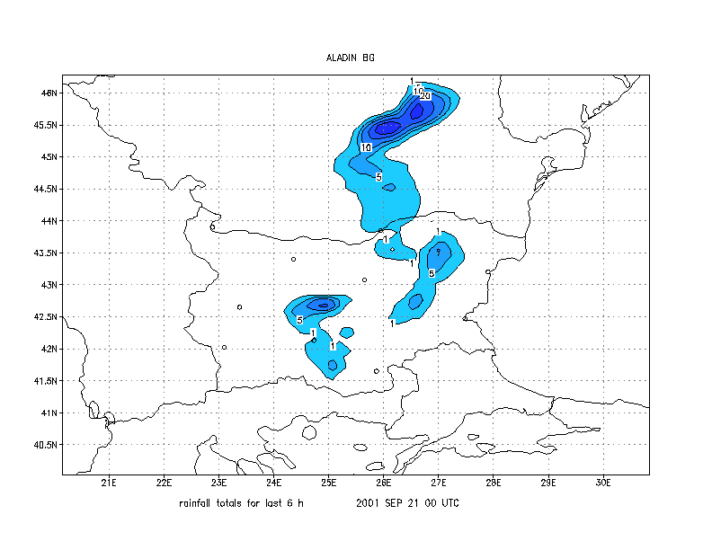
The visualization for predicted rainfall totals and snow quantity was changed : shaded plot was used for the intervals: 1, 5, 10, 15, 20, 30, 50, 80 and more then 80 mm. Either the shade area was bordered by isolines with plotted values. Following the request of forecasters, on every map of forecasted field eight Bulgarian cities are marked with circles. On the figure below is shown an example of new design. Since third quarter of 2000 the graphical output of ALADIN-BG forecast is accessible for our regional branches.
New verification scheme for surface elements was introduced since February of 2001. We use as initial conditions 12h forecast of ARPEGE. That's why for us it is important to verify the ALADIN-BG forecast against the analyses. This explains the presence of estimation for 00 H forecast in verification scores. Verified elements were : 2m temperature, wind speed and direction at 10m, 2m relative humidity and mean-sea-level pressure. For all elements, except the wind direction was calculated the following scores ME - bias, MAE - mean absolute error. For the wind speed the geographical directions were divided in eight categories and was calculated the percentage of points with wind direction in the same category, the next category and other.
|
H |
ME |
MAE |
RMSE |
|---|---|---|---|
|
00 |
-0.464 |
0.854 |
1.136 |
|
12 |
0.465 |
1.008 |
1.423 |
|
24 |
-0.694 |
1.296 |
1.764 |
|
36 |
0.550 |
1.313 |
1.832 |
|
48 |
-0.649 |
1.420 |
1.891 |
Table 1. Verification scores for 2m temperature. April 2001
|
H |
ME |
MAE |
RMSE |
|---|---|---|---|
|
00 |
0.108 |
0.499 |
0,789 |
|
12 |
0.602 |
1,029 |
1,397 |
|
24 |
0.585 |
1,067 |
1,491 |
|
36. |
0.543 |
1,176 |
1,590 |
|
48 |
0.478 |
1,160 |
1,570 |
Table 2. Verification scores for 10m-wind velocity. April 2001
|
H |
ME |
MAE |
RMSE |
|---|---|---|---|
|
00 |
-1,8 |
4,1 |
5,6 |
|
12 |
-9,9 |
12,5 |
15,8 |
|
24 |
-7,2 |
9,4 |
12,8 |
|
36 |
-10,9 |
14,2 |
17,9 |
|
48 |
-7,8 |
10,5 |
14,2 |
Table 3. Verification scores for 2m relative humidity. April 2001
|
H |
ME |
MAE |
RMSE |
|---|---|---|---|
|
00 |
-0,872 |
0,975 |
1,240 |
|
12 |
-0,235 |
1,001 |
1,287 |
|
24 |
-0,527 |
1,253 |
1,583 |
|
36 |
-0,087 |
1,484 |
2,009 |
|
48 |
0,415 |
1,572 |
2,228 |
Table 4. Verification scores for mean-sea-level pressure. April 2001
|
H |
Same |
Next |
Other |
|---|---|---|---|
|
00 |
83,9 |
14,8 |
1,3 |
|
12 |
72,6 |
24,9 |
2,5 |
|
24 |
69,2 |
26,8 |
4,1 |
|
36 |
65,4 |
29,3 |
5,3 |
|
48 |
60,4 |
30,7 |
8,9 |
Table 5. Verification scores for 10m-wind direction. April 2001

The units for the elements are as follows: temperature - K, wind velocity - m/s, relative humidity - %, MSL pressure - hPa, and wind direction - %. All computations were made for model grid points.
A new statistical adaptation scheme has been developed. It is used for interpolation over an orography with finer resolution than the one used in ALADIN-BG or for interpolation to an arbitrary point, respecting the real orography characteristics at this point. This scheme is applicable to orography dependent fields, mainly for the temperature at 2 meters and at the surface. The scheme will be verified using records from automatic stations soon placed in mountain areas. The new scheme will be compared with the forecasted temperature at the closest grid point and with the value obtained by bilinear interpolation

4. In Croatia
See also : "ALADIN/CROATIA : One year experience on PC-Cluster", by Dijana Klaric, in the proceedings of the 10th ALADIN workshop.
5. In Czech Republic

Preparing the ALATNET training course on data assimilation: topic : Blending (case studies)
See also the ALATNET reports.
6. In Hungary
Activities around the workstation version of ALADIN

During the last half year the following main activities were performed around the workstation version of ALADIN:
-- The operational model version is still AL12 however in this period AL13 was installed and probably will be used for the ongoing research and development work (ALATNET). The new surface pressure tendency coupling was coded into that cycle (report of this work is available from Tamas Szabo) as well.
-- The work related to the introduction of new soil texture data into the surface characteristcis of the model had been continued having data assimilation experiments (using CANARI). The results so far doesn't clearly show any significant forecast improvements due to the consideration of more precise local soil data (this work served as a basis for the Master work of Agnes Mika).
-- The work related to the lagged NMC method had been continued too. Sensitivity of the lagged formulation was demonstrated with respect to the forecast lengths and forecast differences used in the algorithm (this work was presented in the last ALADIN workshop and going to appear in the proceedings of that workshop, it is also mentioned that this work forms the Master work of Gergely Boloni).
-- The Kalman-filter algorithm was successfully implemented for the bias-correction of the 2m temperature forecasts of the ALADIN/HU model (this work was also presented as a Master work).
-- Test runs of the ALADIN model on a SUN Ultra Enterprise 10 000 system having 96 UltraSparc 250 MHz processors. The tests showed that these SUN processors are relatively slow (one processor is around 1,5 times slower than an Origin 2000 400 MHz processor), however the scalability of the system is pretty good.
Preparing the ALATNET training course on data assimilation : topics : Variational, DiagPack
See also : "Lagged constant coupling background error statistics : preliminary results for the ALADIN /HU model", by Andras Horanyi and Gergely Bölöni, in the proceedings of the 10th ALADIN workshop, the articles and the ALATNET reports.
7. In Moldavia
Nothing reported.
8. In Morocco

Preparing the ALATNET training course on data assimilation: topics : Variational, Observations
9. In Poland

See also : "Last developments of ALADIN operational environment at IMWM", by Marek Jerczynski, in the proceedings of the 10th ALADIN workshop.
10. In Portugal

Tests are being done in order to introduce operationally version AL12_bf02 (CYCORA-bis). A parallel suite has been run during one and a half month so the objective verification procedures will tell us about this possibility.
The configuration e923 is being tested to version AL12_bf02 as well as a new domain for the ALADIN/Portugal area domain in order to reduce resolution to 10 km.
On the analysis/assimilation field, a scheme for producing CMAFOC files from the Portuguese Meteorological DataBase (PMDB), where observational data is in BUFR format, has been installed, using local developed interfaces, and the packages OULAN and MANDALAY. Moreover, the installation of both CANARI (AL13) and CANARI (AL11) are being tested, the first for diagnostic purposes, using DIAGPACK and the second for assimilation purposes.
Finally, diagnostic tools for severe weather events over Portugal using ALADIN forecasts are being developed and tested.
11. In Romania
 See also : "Tuning
the orography representation in the E923 configuration" by Steluta
Alexandru, "Simulation of the meso-scale convective systems at
different resolutions" by Doina Banciu, "Some applications of
the ALADIN model in Romania" by Mihaela Caian, in the proceedings of
the 10th
ALADIN workshop.
See also : "Tuning
the orography representation in the E923 configuration" by Steluta
Alexandru, "Simulation of the meso-scale convective systems at
different resolutions" by Doina Banciu, "Some applications of
the ALADIN model in Romania" by Mihaela Caian, in the proceedings of
the 10th
ALADIN workshop.
12. In Slovakia

Preparing the ALATNET training course on data assimilation: topic : Structure functions
13. In slovenia

Preparing the ALATNET training course on data assimilation: topic : DiagPack
See also : "Implementation of CAPE and CIN in ALADIN " by Neva Pristov and Jean-Marcel Piriou, in the proceedings of the 10th ALADIN workshop, and the ALATNET reports.

14. In Tunisia
Tunisia just joined the project this semester. Please consult its first report on ALADIN-Tunisia.
15. Deported work by Météo-France people

Nothing this semester.
 |
Home |