


NEMOMED8
Description
NEMOMED8 is a regional version on the Mediterranean Sea of the NEMO-V2 Model (Madec, 2008). The grid and the reference bathymetry are the same as for OPAMED8, but this version is enriched with the partial cells definition: the depth of the last level at each grid point is no more constant, but is adjusted t the real bathymetry. The characteristics can be summarized as follows:
– the resolution of the grid to the 1/8° varies approximately from 12 km in the south to 9 km in the north of the domain; this resolution corresponds approximately to the first ray of deformation and makes the model eddy-permitting and not eddy-resolving like PAM or MED16; the grid is deformed within the Straits of Gibraltar in order to follow the south-western - north-eastern direction and to place there two grid-points in the width
– 43 vertical Z-levels with an inhomogenous distribution from 6 m at the surface to 200 m at the bottom and with 25 levels in the first 1000 meters; the maximum depth is 4100 m in the Eastern basin (cf fig. 1)
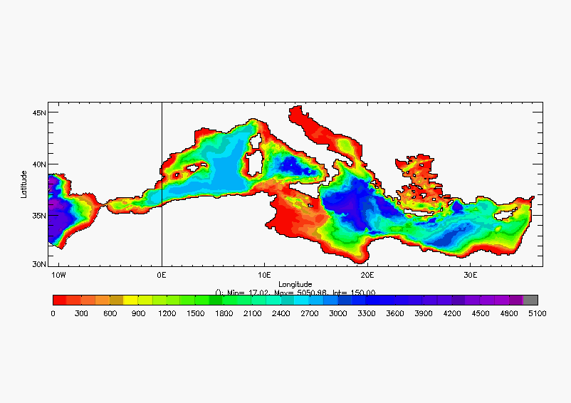
Fig. 1 : bathymetry of NEMOMED8
– a buffer zone is placed in the Atlantic after the Straits of Gibraltar in order to allow the balance of salt and heat of the Mediterranean; one carries out there a relaxation in temperature and salinity from the surface to the bottom towards the climatology of Reynaud (Reynaud and al, 1998); this relaxation is very strong at the most distant point from Gibraltar (3 days) then decreases when approaching it (100 days)
– the free surface hypothesis is applied at the surface; a free-slip lateral boundary condition is used; the time-step is 20 minutes;
– the model can be used in forced configuration by fluxes resulting from atmospheric simulations, or coupled with the AGCM ARPEGE-Climate with the mediash grid (centered in the Tyrrhenian Sea, approximately 50 km of resolution on the Mediterranean), or also coupled with the ALADIN-Climate regional model (CNRM-RCSM4 coupled model, Sevault et al., 2014); besides the TRIP river runoffs model can be introduced in the system, in its 1° or 0.5° versions (Oki and Sud, 1998, Decharme et al., 2010);
– the Black Sea is not included in the grid of the model, it is treated as a river because of its very low salinity, and thus one represents the difference of salinity resulting from the currents at the Dardanelles Strait; moreover, when the TRIP model is not present, we use the monthly climatological or interannual runoff of the 33 main rivers of the Mediterranean Sea catchment basin, which makes it possible not to use any salinity relaxation, depending if the atmospheric water flux is good enough.
Applications
The NEMOMED8 regional model of the Mediterranean initially makes it possible to represent the thermohaline circulation in this basin. It is imposed by the water and heat losses on its surface, from where the importance of the fluxes which are imposed on the model. From there, the fields of study which we explore are as follows:
– study of the Mediterranean Sea interannual variability and tendencies, with comparison to the observations when the model is forced by the statistical downscaling by ARPEGE-Climate of the ERA40 reanalysis fluxes from the NCEP;
– simulation of the impact of climate change: we compute various simulations of the 21st century following scenarios from the GICC
– comparison between forced and coupled simulations: impact of an interactive Mediterranean on the climate and/or impact of an interactive atmosphere on the Mediterranean Sea
– use of the fields resulting from NEMOMED8 simulations to force a coastal ocean model (SYMPHONIE) at its boundaries.
Collaborations
The LOCEAN, l’ENSTA, and the MERCATOR group are the principal interlocutors. The Laboratory of Aerology (Observatoire Midi-Pyrénées) for the studies using the coastal ocean model SYMPHONIE.
Publications and technical reports associated to the model
2019:
Darmaraki, S., Somot, S., Sevault, F., Nabat, P., Cabos, W., Cavicchia, L., Djurdjevic, V., Li, L., Sannino, S., Sein, V.D. (2019), Future evolution of Marine Heatwaves in the Mediterranean Sea, Climate Dynamics, in press, DOI:10.1007/s00382-019-04661-z.
Dunić, N., Vilibić, I., Šepić, J., Mihanović, H., Sevault, F., Somot, S., Waldman, R., Nabat, P., Arsouze, T., Pennel, R., Jordà, G., and Precali, R. (2019), Performance of multi-decadal ocean simulations in the Adriatic Sea, Ocean Modelling, 134, 84-109, DOI:10.1016/j.ocemod.2019.01.006.
2018:
Harzallah, A., Jordà, G., Dubois, C., Sannino, G., Carillo, A., Li, L., Arsouze, T., Cavicchia, L., Beuvier, J., Akhtar, N. (2018): Clim Dyn (2018) 51: 1145. https://doi.org/10.1007/s00382-016-3363-5
2016:
Dunić N., Vilibić I., Šepić J., Somot S., Sevault F. (2016) Dense water formation and BiOS-induced variability in the Adriatic Sea simulated using an ocean regional circulation model. Climate Dynamics, 1-26, Med-CORDEX special issue, doi:10.1007/s00382-016-3310-5
Somot S., Houpert L., Sevault F., Testor P., Bosse A., Taupier-Letage I., Bouin M.N., Waldman R., Cassou C., Sanchez-Gomez E., Durrieu de Madron X., Adloff F., P. Nabat, Herrmann M. (2016) Characterizing, modelling and understanding the climate variability of the deep water formation in the North-Western Mediterranean Sea. Climate Dynamics, 1-32, doi: 10.1007/s00382-016-3295-0, (available on-line: http://link.springer.com/article/10.1007/s00382-016-3295-0)
2015:
Adloff F., Somot S., Sevault F., Jordà G., Aznar R., Déqué M., Herrmann M., Marcos M., Dubois C., Padorno E., Alvarez-Fanjul E., Gomis D. (2015) Mediterranean Sea response to climate change in an ensemble of twenty first century scenarios. Climate Dynamics, 45 (9), 2775-2802, doi:10.1007/s00382-015-2507-3
Soto-Navarro J., Somot S., Sevault F., Beuvier J., Criado-Aldeanueva F., García-Lafuente J., Béranger K. (2015) Evaluation of regional ocean circulation models for the Mediterranean Sea at the strait of Gibraltar: volume transport and thermohaline properties of the outflow. Climate Dynamics, 44, 1277–1292, doi: 10.1007/s00382-014-2179-4
2014:
Sevault F., Somot S., Alias A., Dubois C., Lebeaupin-Brossier C., Nabat P., Adloff F., Déqué M. And Decharme B. (2014) Ocean simulation of the 1980-2012 period for the Mediterranean Sea using a fully-coupled atmosphere-land-hydrology-river-ocean Regional Climate System Model: design and evaluation. Tellus A: Dynamic Meteorology and Oceanography, 66(1), 23967
2013:
L’Heveder B., Li L., Sevault F., Somot S. (2013) Interannual variability of deep convection in the Northwestern Mediterranean simulated with a coupled AORCM. Climate Dyn., 41:937-960. doi: 10.1007/s00382-012-1527-5
2010:
Beuvier J., F. Sevault, M. Herrmann, H. Kontoyiannis, W. Ludwig, M. Rixen, E. Stanev, K. Béranger, S. Somot (2010) Modelling the Mediterranean Sea interannual variability over the last 40 years: focus on the EMT, JGR-Ocean, 115, C08017, doi:10.1029/2009JC005950.
Herrmann M., Sevault F., Beuvier J., Somot S. (2010) What induced the exceptional 2005 convection event in the Northwestern Mediterranean basin ? Answers from a modeling study.
JGR-O (in press), doi:10.1029/2010JC006162
Sevault F. (2010): A 1961-2008 simulation of the Mediterranean Sea with NEMOMED8. Note interne. pdf
2009:
Sevault F., S. Somot, J. Beuvier, 2009 : A regional version of the NEMO Ocean Engine on the Mediterranean Sea : NEMOMED8 user’s guide. Note de centre GMGEC, CNRM, n°107. pdf
References
Decharme B., R. Alkama, H. Douville, M. Becker, A. Cazenave (2010) Global evaluation of the ISBA-TRIP continental hydrological system. Part 2: Uncertainties in river routing simulation related to flow velocity and groundwater storage. Journal of Hydrometeorology: In Press
Madec G., 2008 : NEMO ocean engine - version3.1 -. Note du Pôle de modélisation de l’IPSL n°27.
Oki T. and Y. C. Sud, 1998 : Design of Total Runoff Integrating Pathways (TRIP) - A global river channel network. Earth Interactions, 2.
Reynaud T., P. Legrand, H. Mercier, B. Barnier, 1998: A new analysis of hydrographic data in the Atlantic and its application to an inverse modeling study. International WOCE Newsletters 32:29-31.