CNRM RCSM6
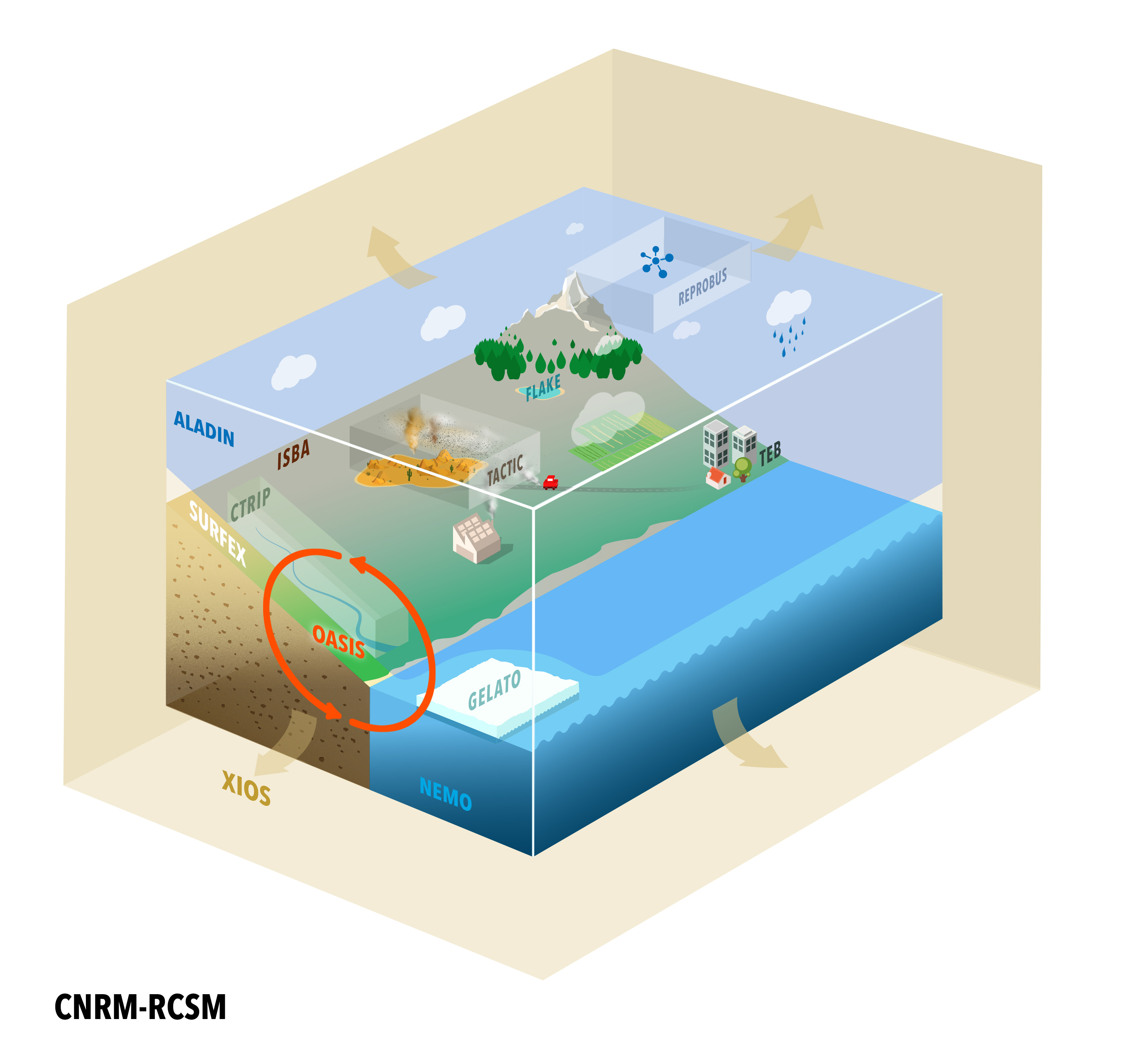
- Introduction and scientific choices
– Improve the CNRM-RCSM4 coupled model formerly used (Sevault et al. 2014) ;
– Follow the last version of the CNRM-CERFACS GCM, used for the CMIP6 intercomparison (Description, references) ;
– Follow the MedCORDEX recommendations for the inter-comparison ;
– Use up-to-date components as lateral boundary conditions (LBC), initial conditions and forcing. - Model components
– ALADIN_Climate V6 (Daniel et al., 2019) : 12 km resolution, 91 levels, with interactive aerosols with TACTIC (Michou et al., 2015), SURFEX v8.0 externalised surface system (Voldoire et al., 2017), in which the ISBA-CTRIP land surface system and the FLake lake scheme (Le Moigne et al., 2016) are embedded ;
– ISBA-CTRIP (Decharme et al., 2019) : floodplains, groundwater diffusive scheme, variable velocity, 50 km resolution ;
– NEMOMED12 (Beuvier et al., 2012 for v3.2) : regional version of NEMOv3.6 (Madec et al., 2008), 6-8 km resolution ;
– OASIS3-MCT (Craig et al., 2017) : 1-hr coupling frequency. - Domain

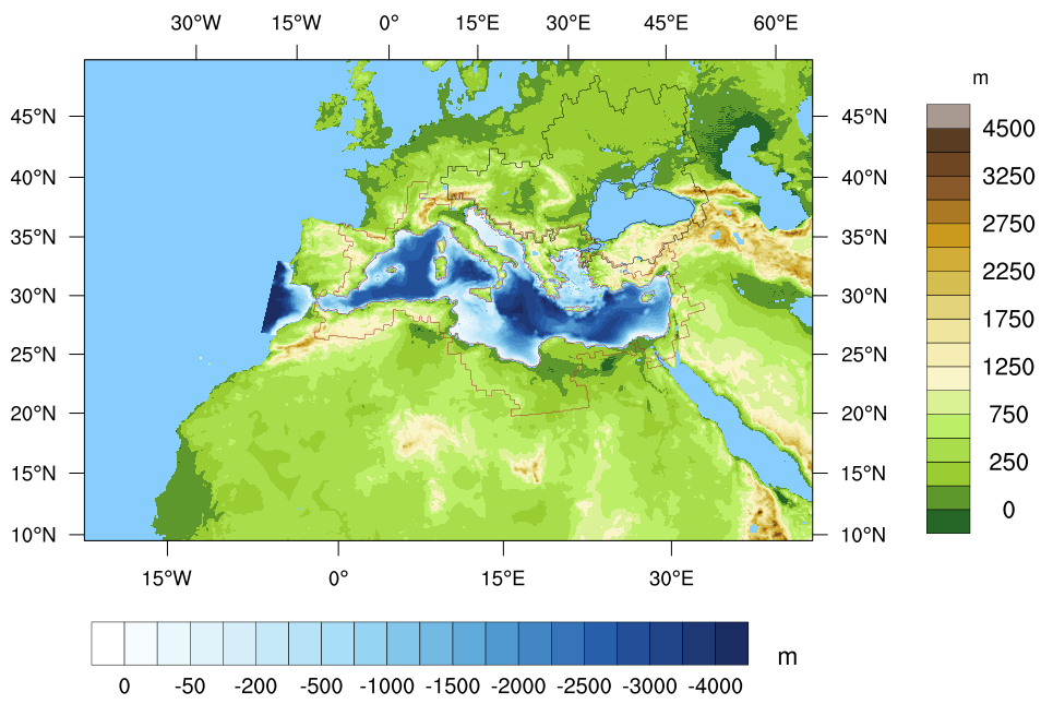
ALADIN-Climate land-sea mask and orography (in m) for the AAD12 domain, and NEMOMED12 bathymetry (in m). The drainage areas of the Black Sea (in black) and the Mediterranean Sea (in red) are contoured.
- Set-up explanations
The river runoffs computed by SURFEX are sent to the CTRIP model, and the river discharges at the river mouths are sent by CTRIP to the ocean model. Only the CTRIP cells included in the Mediterranean and Black Sea drainage area are considered ; for the Nile river basin, the runoff is prescribed by a 12-month climatology, as for CNRM-RCSM4. The NEMOMED12 ocean model doesn’t consider the Black Sea in its domain, and the latter is considered as a river inducing the difference of salinity between the Aegean Sea and the Marmara Sea. In the coupled system, the river discharges of the Black Sea drainage area (58 river mouths in the CTRIP 0.5° grid) are summed with the Evaporation minus Precipitation (E-P) budget from SURFEX over the Black Sea. The 0.5° resolution of the CTRIP grid is coarser than the atmosphere and ocean ones, and will be modified as soon as a finer one is available. Outside the domain of NEMOMED12 in the Atlantic Ocean, the Baltic Sea and the Black Sea, an SST field must also be provided to the atmospheric model ; it is usually coming from the same dataset as the lateral boundary conditions supplied to the regional atmospheric model. - References
– Rusu L. (2024), An analysis of the expected wave conditions in the Mediterranean Sea in the context of global warming, Ocean Engineering, Volume 301, 2024, 117487, ISSN 0029-8018, https://doi.org/10.1016/j.oceaneng.2024.117487
– Sevault F. (2024). Atlas of the 1980-2018 ERA-Interim simulation with the coupled regional climate system model CNRM-RCSM6. Zenodo. https://doi.org/10.5281/zenodo.10726157
– Darmaraki S., Somot S., Sevault F., Nabat P. (2019) Past Variability of Mediterranean Sea Marine Heatwaves. GRL, https://doi.org/10.1029/2019GL082933
– Decharme B., Delire C., Minvielle M., Colin J., Vergnes J.-P., Alias A., Saint-Martin D., Séférian R., Sénési S., Voldoire A., (2019) Recent changes in the ISBA‐CTRIP land surface system for use in the CNRM‐CM6 climate model and in global off‐line hydrological applications. Journal of Advances in Modeling Earth Systems, 11. https://doi.org/10.1029/2018MS001545
– Le Moigne P., Colin J., Decharme B. (2016) : Impact of lake surface temperatures simulated by the FLake scheme in the CNRM-CM5 climate model, Tellus A : Dynamic Meteorology and Oceanography, 68:1, DOI : 10.3402/tellusa.v68.31274
– Michou M., Nabat P., Saint-Martin D. (2015) : Development and basic evaluation of a prognostic aerosol scheme (v1) in the CNRM Climate Model CNRM-CM6, Geosci. Model Dev., 8, 501-531, https://doi.org/10.5194/gmd-8-501-2015
– Sevault F., Somot S., Alias A., Dubois C., Lebeaupin-Brossier C., Nabat P., Adloff F., Déqué M. & Decharme B. (2014) A fully coupled Mediterranean regional climate system model : design and evaluation of the ocean component for the 1980–2012 period, Tellus A : Dynamic Meteorology and Oceanography, 66:1, DOI : 10.3402/tellusa.v66.23967
– Voldoire A., Decharme B., Pianezze J., Lebeaupin-Brossier C., Sevault F., Seyfried L., Garnier V., Bielli S., Valcke S., Alias A., Accensi M., Ardhuin F., Bouin M.N., Ducrocq V., Faroux S., Giordani H., Léger F., Marsaleix P., Rainaud R., Redelsberger J.-L., Richard E., Riette S. (2017) SURFEX v8.0 interface with OASIS3-MCT to couple atmosphere with hydrology, ocean, waves and sea-ice models, from coastal to global scales. Geosci. Model Dev., 10, 4207–4227, 2017, https://doi.org/10.5194/gmd-10-4207-2017