


LDAS
The LDAS (Land Data Assimilation System) developed by CNRM permits the integration of satellite products into the ISBA Land Surface Model (LSM) using a data assimilation scheme. The obtained reanalysis accounts for the synergies of the various upstream products and provides statistics which can be used to monitor the quality of the assimilated observations. The ISBA generic LSM is able to represent the diurnal cycle of the surface fluxes together with the seasonal, interannual and decadal variability of the vegetation biomass. The LSM is embedded in the SURFEX modeling platform together with a simplified extended Kalman filter. These tools, together with a python chain governing the data flow, form the LDAS.
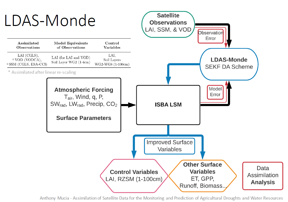
With LDAS-Monde, various Earth observation satellite products (leaf area index - LAI, surface soil moisture - SSM, microwave vegetation optical depth - VOD, etc.) can be integrated in the ISBA land surface model. Model control variables that do not generally present very fast changes are "analyzed" when observations are available. In this way, better initial conditions are obtained for plant biomass and root-zone soil moisture. Modelling errors are reduced for these variables and also for other simulated variables such as evapotranspiration, photosynthesis, runoff, etc. It must be noticed that LDAS-Monde has the unique capability of analyzing root-zone soil moisture by assimilating LAI alone. This analysis can also be produced by assimilating LAI together with surface soil moisture.
LDAS-France
The LDAS-France version assimilates the European Copernicus Global Land Service (http://land.copernicus.eu/global/) LAI and ASCAT surface soil moisture (SSM) products over France (8km x 8km). The LDAS is operated over France, and generates statistics whose trends can be analyzed in order to detect possible drifts in the quality of the products: (1) for LAI and SSM, metrics derived from the active monitoring (i.e. assimilation) such as innovations (observations vs. model forecast), residuals (observations vs. analysis), and increments (analysis vs. model forecast) ; (2) for albedo, LST, and FAPAR, metrics derived from the passive monitoring such as the Pearson correlation coefficient, z-score, RMSD, SDD, mean bias.
A passive monitoring of albedo, FAPAR and Land Surface temperature (LST) is performed (i.e., the simulated values are compared with the satellite products). In situ SSM data over France are used to verify the outcomes of the analysis.
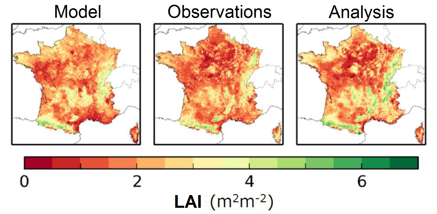
In the following Figure, LAI over France in August during the 2015 summer drought is simulated by ISBA, derived from Copernicus satellite observations, and analyzed i.e. simulated by ISBA after integrating observations (left, center, right, respectively).
LDAS-Monde
The LDAS was extended to a global scale (LDAS-Monde) at a spatial resolution of 0.25 degrees x 0.25 degrees (longitude, latitude). At the same time, the coupling to hydrological models was consolidated, and this allows the use of in situ river discharge observations for the validation of the whole system.
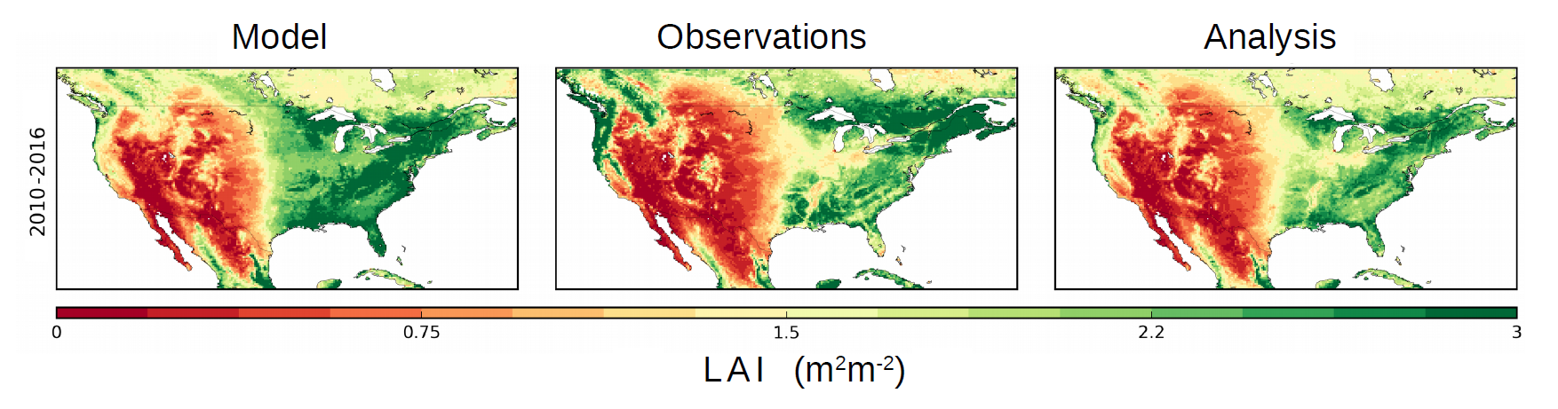
In the following Figure, LAI over north America from 2011 to 2016 is simulated by ISBA, derived from Copernicus satellite observations, and analyzed i.e. simulated by ISBA after integrating observations (left, center, right, respectively).
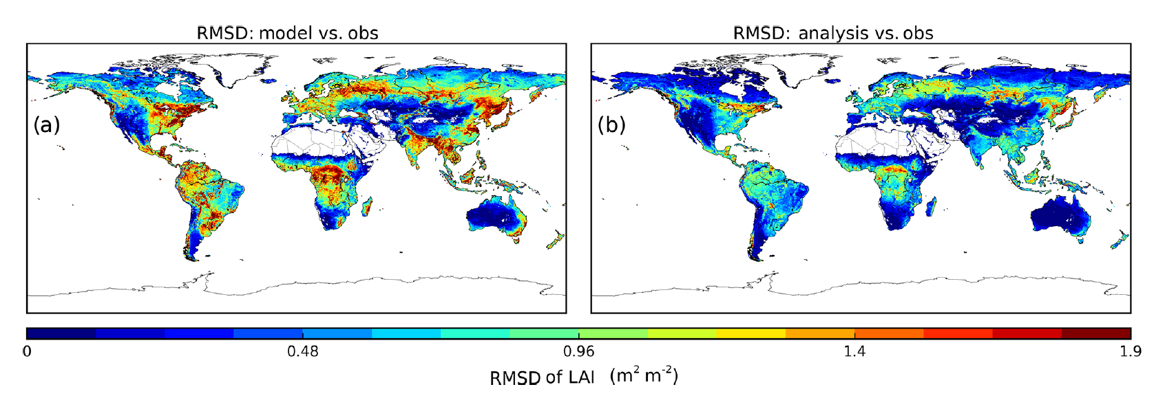
The Figure presented below shows the Root Mean Squared Deviation of the simulated LAI with respect to satellite-derived LAI (left) before assimilation and (right) after assimilation. Reproduced from Albergel et al. 2020 (Figure 3).
How does it work?
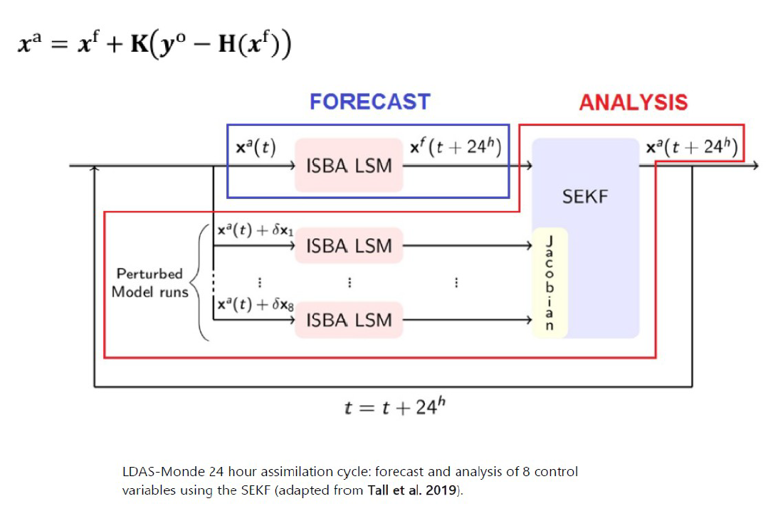
The sequential data assimilation technique used in LDAS-Monde is called simplified extended Kalman filter (SEKF). Fixed estimates of background error variances are used, without considering spatial covariances. LDAS-Monde optimally combines ISBA outputs and satellite observations in order to provide an analysis. The analysis is an improved model trajectory of the simulated soil moisture and LAI. LDAS-Monde is run with a 24 hour assimilation window with each 24 hour cycle consisting of two steps: a forecast step and an analysis step.
The forecast step propagates the state of the system from the initial time t to t + 24 hours using the ISBA model. As explained by Barbu et al. (2014) and Bonan et al. (2020), for each ISBA grid cell, the forecast of x denoted by xf(t+24h), relies on the analysis at time t, xa(t). The notation ‘a’, ‘f’, and ‘o’ are superscripts for analysis, forecast and observation, respectively. The term x is used to indicate the control vector that is computed at a given time characterizing the prognostic equations of the ISBA LSM. The term y is use to designate the observations (yo) or the model equivalent of the observations (yf). Once the x model state variable has been propagated in time, a non-linear observation operator H is used to transform x to the model equivalent of the observations. In the SEKF, the model equivalent of the observations yf = H(xf) is calculated and compared with the observations at the model grid-cell level.
In the analysis step, the Kalman gain K is calculated using a Jacobian matrix. LDAS-Monde is able to jointly assimilate LAI and SSM observations. Alternatively, only LAI, or only SSM can be assimilated. A unique property of LDAS-Monde is that LAI observations can be used to analyze the root-zone soil moisture.
Publications
– Albergel, C., Dutra, E., Bonan, B., Zheng, Y., Munier, S., Balsamo, G., de Rosnay, P., Munoz-Sabater, J., and Calvet, J.-C.: Monitoring and forecasting the impact of the 2018 summer heatwave on vegetation, Remote Sens., 11, 520, https://www.doi.org/10.3390/rs11050520, 2019.
– Albergel, C., Dutra, E., Munier, S., Calvet, J.-C., Munoz-Sabater, J., de Rosnay, P., and Balsamo, G.: ERA-5 and ERA-Interim driven ISBA land surface model simulations: which one performs better?, Hydrol. Earth Syst. Sci., 22, 3515-3532, https://doi.org/10.5194/hess-22-3515-2018, 2018.
– Albergel, C., S. Munier, A. Bocher, B. Bonan, C. Draper, E. Dutra, D. J. Leroux, A. L. Barbu, Y. Zhang, and J.-C. Calvet: LDAS-Monde sequential assimilation of satellite derived observations applied to the contiguous US: an ERA-5 driven reanalysis of the land surface variables, Remote Sensing, 10, 1627, 24 pp., https://doi.org/10.3390/rs10101627, 2018.
– Albergel, C., S. Munier, D. J. Leroux, H. Dewaele, D. Fairbairn, A. L. Barbu, E. Gelati, W. Dorigo, S. Faroux, C. Meurey, P. Le Moigne, B. Decharme, J.-F. Mahfouf, J.-C. Calvet: Sequential assimilation of satellite-derived vegetation and soil moisture products using SURFEX_v8.0: LDAS-Monde assessment over the Euro-Mediterranean area, Geosci. Model Dev., 10, 3889–3912, https://doi.org/10.5194/gmd-10-3889-2017, 2017.
– Albergel, C., Zheng, Y., Bonan, B., Dutra, E., Rodríguez-Fernández, N., Munier, S., Draper, C., de Rosnay, P., Muñoz-Sabater, J., Balsamo, G., Fairbairn, D., Meurey, C., and Calvet, J.-C.: Data assimilation for continuous global assessment of severe conditions over terrestrial surfaces, Hydrol. Earth Syst. Sci., 24, 4291–4316, https://doi.org/10.5194/hess-24-4291-2020, 2020.
– Barbu, A. L., Calvet, J.-C., Mahfouf, J.-F., Albergel, C., and Lafont, S.: Assimilation of Soil Wetness Index and Leaf Area Index into the ISBA-A-gs land surface model: grassland case study, Biogeosciences, 8, 1971–1986, https://doi.org/10.5194/bg-8-1971-2011, 2011.
– Barbu, A. L., Calvet, J.-C., Mahfouf, J.-F., and Lafont, S.: Integrating ASCAT surface soil moisture and GEOV1 leaf area index into the SURFEX modelling platform: a land data assimilation application over France, Hydrol. Earth Syst. Sci., 18, 173-192, https://doi.org/10.5194/hess-18-173-2014, 2014.
– Blyverket, J., Hamer, P.D., Schneider, P., Albergel, C., Lahoz, W.A: Monitoring soil moisture drought over northern high latitudes from space, Remote Sens., 11, 1200, https://www.mdpi.com/2072-4292/11/10/1200, 2019.
– Blyverket, J. ; Hamer, P.D. ; Bertino, L. ; Albergel, C. ; Fairbairn, D. ; Lahoz, W.A. An Evaluation of the EnKF vs. EnOI and the Assimilation of SMAP, SMOS and ESA CCI Soil Moisture Data over the Contiguous US. Remote Sens., 11, 478, https://doi.org/10.3390/rs11050478, 2019.
– Bonan, B., Albergel, C., Zheng, Y., Barbu, A. L., Fairbairn, D., Munier, S., and Calvet, J.-C. : An ensemble square root filter for the joint assimilation of surface soil moisture and leaf area index within the Land Data Assimilation System LDAS-Monde: application over the Euro-Mediterranean region, Hydrol. Earth Syst. Sci., 24, 325–347, https://doi.org/10.5194/hess-24-325-2020, 2020.
– Corchia, T., Bonan, B., Rodríguez-Fernández, N., Colas, G., Calvet, J.-C : Assimilation of ASCAT Radar Backscatter Coefficients over Southwestern France, Remote Sens., 15, 4258. https://doi.org/10.3390/rs15174258, 2023.
– Dewaele, H., Munier, S., Albergel, C., Planque, C., Laanaia, N., Carrer, D., and Calvet, J.-C.: Parameter optimisation for a better representation of drought by LSMs: inverse modelling vs. sequential data assimilation, Hydrol. Earth Syst. Sci., 21, 4861–4878, https://doi.org/10.5194/hess-21-4861-2017, 2017.
– Fairbairn, D., Barbu, A.L., Mahfouf, J.-F., Calvet, J.-C., and Gelati, E.: Comparing the ensemble and extended Kalman filters for in situ soil moisture assimilation with contrasting conditions, Hydrol. Earth Syst. Sci., 19, 4811–4830, https://doi.org/10.5194/hess-19-4811-2015, 2015.
– Fairbairn, D., Barbu, A. L., Napoly, A., Albergel C., Mahfouf, J.-F., and Calvet, J.-C.: The effect of satellite-derived surface soil moisture and leaf area index land data assimilation on streamflow simulations over France, Hydrol. Earth Syst. Sci., https://doi.org/10.5194/hess-21-2015-2017, 21, 2015–2033, 2017.
– Leroux, D., J.-C. Calvet, S. Munier, and C. Albergel: Using satellite-derived vegetation products to evaluate LDAS-Monde over the Euro-Mediterranean area, Remote Sensing, 10, 1199, 21 pp., https://doi.org/10.3390/rs10081199, 2018.
– Mucia, A., Bonan, B., Zheng, Y., Albergel, C., Calvet, J.-C. From Monitoring to Forecasting Land Surface Conditions Using a Land Data Assimilation System : Application over the Contiguous United States. Remote Sens. 2020, 12, https://doi.org/10.3390/rs12122020, 2020.
– Mucia, A., Bonan, B., Albergel, C., Zheng, Y., and Calvet, J.-C.: Assimilation of passive microwave vegetation optical depth in LDAS-Monde: a case study over the continental USA, Biogeosciences, 19, 2557–2581, https://doi.org/10.5194/bg-19-2557-2022, 2022.
– Rojas-Munoz, O., Calvet, J.-C., Bonan, B., Baghdadi, N., Meurey, C., Napoly, A., Wigneron, J.-P., Zribi, M: Soil Moisture Monitoring at Kilometer Scale: Assimilation of Sentinel-1 Products in ISBA, Remote Sens., 15, 4329, https://doi.org/10.3390/rs15174329, 2023.
– Tall, M., Albergel, C., Bonan, B., Zheng, Y., Guichard, F., Dramé, M. S., Gaye, A. T., Sitondji, L. O., Hountondji, F. C. C., Nikiema, P. M., Calvet, J.-C.: Towards a long-term reanalysis of land surface variables over western Africa: LDAS-Monde applied over Burkina Faso from 2001 to 2018, Remote Sensing, 11, 735, https://www.doi.org/10.3390/rs11060735, 2019.
– Zheng, Y., Albergel, C., Munier, S., Bonan, B., and Calvet, J.-C.: An offline framework for high-dimensional ensemble Kalman filters to reduce the time to solution, Geosci. Model Dev., 13, 3607–3625, https://doi.org/10.5194/gmd-13-3607-2020, 2020.