
Please consult also the summary of (pre-)operational configurations.
Changes in the operational version of ARPEGE along the first half of 2001
First changes in the operational version of ARPEGE along the second half of 2001
"New cycles", operational from September 11th: it involves 7 changes, the impact of which is expected to be nearly neutral :
Two weeks of parallel suite in August showed a neutral behaviour for ARPEGE in
data assimilation mode and one quasi-identical ALADIN forecast in dynamical
adaptation mode. However some tasks are not yet ready and optimizations still required.
This modification avoids using land points in the computation of obs-guess
increments over sea and vice-versa, with consequences on coastal areas for
SST, T2m and H2m analyses (hence on initial surface temperature and moisture).
This leads to smoother increments for surface fields, especially SST.
Less horizontal diffusion at low resolution, i.e. T42/T63/T95, especially on
divergence, should lead to less "incrementality" of the minimisation
with respect to the T199 model, hence to a slightly better analysis.
It is just to improve consistency between the inner and outer loops of 4d-var
and prepare the jump to 41 levels.
The problems of Saharan fictitious precipitations (which increased from 3d-var
to 4d-var) and of some erratic behaviour of the relative humidity field from
one run to the next one (even on data richer areas) were partly explained and
corrected. Since geopotential depends on humidity via the vertical integral of [Rd+(Rv-Rd).q].T.d(lnp)
(virtual temperature effect), there exist situations where the 4d-var
minimization finds it easier to fit height (or wind) data through a change of
q than through a change of T, even if the q change has to be substantial in
magnitude to achieve this goal. A temporary but efficient solution is to reset
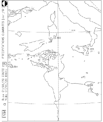
Rv=Rd when entering the TL/AD computations, and only there. The impact of such
a change is illustrated by the figures on the cumulated (6h) precipitations in
the test and the operational
ARPEGE forecasts (forecasts starting on 27/08/2001 at 00 UTC, valid at 18 UTC).
The main changes in the operational environment are described in the report on deported
work.
Preparations have been made during the first six months of 2001 for the change
of operational computer at RMI : the old CRAY will be shortly replaced with a
more powerful SGI Origin 3400 computer.
Last news in Newsletter16.
HW configuration
- 4 x PC KAYAK600 2 proc. PENTIUM III-Coppermine
(Intel) 800 MHz, 256 Mb RAM
- 3 x PC KAYAK600 2 proc. PENTIUM III-Coppermine
(Intel) 667 MHz, 256 Mb RAM
- HP ProCurve Switch 2424M - 100 Mb/sec switch
- Ethernet 100 Mb cables
- Red Hat Linux 6.2 (Kernel 2.2.16)
- Fujitcu F90 compiler
- MPICH package - message passing library 1.2.0
ALADIN / CROATIA application
Main news in domain size: increasing of domain and decreasing of resolution.
- version of ALADIN : cycle AL12T1
- coupled with ALADIN/LACE (12km resolution)
- integration for 48 hours / once per day (00 UTC)
- number of vertical levels : 31
- time needed for Lancelot (ee927) is ~2 minutes at
one 2 proc. PC 667 MHz
- number of points : 72x72 (80x80) - Slovenian
domain
- resolution : 11.16 km
- time step : 400 sec (432 steps for a 48 hour
integration)
- domain :
SW corner (lat,lon) : 42.53 ° N, 8.68 ° E
NE corner (lat,lon) : 49.44 ° N, 18.89 ° E
- time needed per run : 30 min
- number of points : 144x120 (127x109)
- resolution : 8 km
- time step 327.273 sec (528 steps for 48 hour
integration)
- domain :
SW corner (lat,lon) : 41.79 ° N, 8.93 ° E
NE corner (lat,lon) : 49.53 ° N, 21.98 ° E
- time needed per run : 90 min
Applications
- Vis5D : meteorological fields map of surface
parameters (2m- temperature, surface pressure, 2m- relative humidity, 10m-
wind, precipitation and cloudiness) and upperair parameters in low atmosphere
(horizontal wind, vertical velocity, temperature and geopotential on 10
pressure levels 1000 - 500 hPa) of ALADIN/CROATIA
- Grads : HRID's in 45 points for ALADIN/LACE and
ALADIN/CROATIA models
- visualization of ALADIN/LACE GRIB products
- number of grid points : 80x80 (72x72)
- resolution : 2 km
- 15 vertical levels
- integration time : 3 min per 1 time window
- every day run for see-side domains : Dubrovnik,
Split, Maslenica, Senj
- run on demand for other domains : Karlovac,
Varazdin, Pakrac, Osijek
- preparation of input files for HYSPLIT_4
transport and dispersion model on demand
- production of html pages with ALADIN/LACE and
ALADIN/CROATIA maps
On 24th of January, the ALADIN mesh-size diminished from 9.9 km to 9.5 km ;
orography and land-sea mask were thus slightly improved. Part of the problems
due to the finer resolution of the post-processing grid (unrealistic plots of
2m fields on lakes, estuaries, peninsulas or islands) disappeared. Both
operational and test suites are used to detect any anomalies.
The porting of the export version AL13_01 on SUN was completed. That of AL15
is under progress. A specific workstation problem was identified in AL13_01,
due to new "tiling" surface parameterization in the IFS physics. It
was mentioned to the alabobo list.
A high resolution ALADIN-Gourdon model, coupled to ALADIN-France, was running daily along June 2001, thanks to Jean-Daniel Gril, and the forecasts were sent to the ALATNET seminar. The mesh-size was 5 km, with 37 vertical levels.
The main changes in the operational environment are described in the report on deported
work.
The ALADIN/LACE application switched to the new physical package denoted as
CYCORA-BIS" on:
The CYCORA-BIS package is based on the ALADIN library AL12_op6 /CY22_op6. This
library also enabled to compute new instantaneous physical fluxes: CAPE,
MOCON, WIND GUSTS and PBL HEIGHT. These new products were added to the
distribution list of gribbed outputs of ALADIN/LACE. A short scientific
description on the definition and computation of these fields was prepared by
Project Scientific Officer.
After having prepared the blending scripts and namelists (also for the library
level of CYCORA-BIS) and solved the synchronization of the blending
assimilation cycle and the production runs, the blending was put under
operations on:
However, after a few days when comparing the scores of the blending suite to
the dynamical adaptation suite (which still run in parallel for a control) a
problem was noticed at the surface (see the parallel suite abf").
Therefore the suite was immediately switched back to the dynamical adaptation on:
The problem of surface fields was found rapidly: it was a mishandling of the
monthly constants (such like vegetation index, albedo, emissivity, etc.), when
the blending algorithm retained always the monthly constants of the guess.
Thus the same monthly constants were carried through since a cold start. Since
the last cold start to prepare the blending suite for the operational
application took place in January, the winter-type constants were retained. In
the beginning of May, when the weather changed from winter to spring regime, a
chock in the daily scores of 2m temperature was very nicely marked. In some
way it was a good luck to obtain such a signal leading directly to the source
of the problem. The technical mistake in the scripts was fixed rapidly and the
blending suite was retested (test abg"). The final switch to
blending took place on
Thus ALADIN/LACE is the first application where this type of downscaling
algorithm was successfully implemented in the operational practice. Blending
may be seen like a first step toward the data assimilation applied on a
limited area, or in other words, like the first outer-loop in a
multi-incremental data assimilation algorithm fixing the long wave part of the
spectra.
The technique of blending was entirely developed, comprehensively tested and
implemented by RC LACE Prague Team. The blending method is described in a
technical note written by Dominique Giard (available on ALADIN web server).
The technical details on the concrete implementation of blending in
ALADIN/LACE may be asked to Filip Vana, Maria Siroka, Dijana Klaric and
Radmila Brozkova. On demand, the scripts and source codes are available
(contact Filip Vana).
The mistake in handling the monthly constants is pedagogically important. It
says that when running even the simplest possible assimilation cycle, all its
aspects must be very carefully checked. It has always been said within the
ALADIN community that it is dangerous to run the model like a black box. This
is twice more true for any data assimilation application.
Parallel Suites & Code Maintenance
The Prague Team launched the following parallel tests to assess the impact of different modifications:
ALADIN/Morocco still being run on Cray J90, using AL12 either in analysis and
forecast modes. AL13 has been successfully ported in both SM and DM modes. DM
mode is based on MPICH2 adapted for Cray. The performances of this mode,
however, are very bad as MPICH2 is not optimized for Cray J90. The SM mode
with LMLTSK=.TRUE. and NTASKS greater than 1 is not running.
Theses last two reasons made it impossible to use AL13 operationally. AL13
still however be used for development aims. The configurations tested with
AL13 on Cray are E001, E701, EE927, Full-Pos, Screening (screening is not
working if the observation file contains SATEM messages).
To be able to go far with the new versions of ALADIN, DMN/Morocco is changing J90 machine by another new one IBM SP 2 POWER 3. This last new machine is already installed and all the above mentioned configurations are running without any difficulties and with great performances.
The machine contains three parallel nodes : two computation nodes equipped by 16 processors of 1.5 GFlops each (in scalar mode computation) and a third node equipped by 4 processors dedicated for file server tasks. The machine is 19 GB of memory and 1 TB hard disk managed by GPFS (Global Parallel File System). The communications between the nodes is ensured thanks to a high speed switch called "Colony" (1GB/s).
Briefly, the machine is 54 GFlops power : CANARI analysis followed by 60 hours forecast in parallel with 13 EE927 is performed in 18 minutes on just one node. This time become less than 12 minutes when using 2 nodes. (for remember, ALADIN/Morocco is 180/180/L31).
All the efforts are now focusing on putting this machine into operations ; the ultimate date for this purpose is the end of September. The operational suite will be based on a powerful task sequencer called LoadLeveler.
NB : The archiving system which was stopped for some technical reasons, will continue to work on a new hardware, also an IBM based one, called IBM LTO 3584, which can handle backup, archive, HSM, and disaster recovery data storage needs with ease. This will handle our growing storage requirements.
For more information concerning our new computing configuration, another more detailed article will appear in the next newsletter.
The main changes in the operational environment are described in the
proceedings of the 10th ALADIN workshop : "Last
developments of ALADIN operational environment at IMWM", by Marek Jerczynski.
The main changes in the operational environment are described in the report on deported
work.
No change since the report in Newsletter18.
Last news in Newsletter 19.
Last news in Newsletter16 .
This is the first report of our new Partner who entered
the ALADIN project officially on May 31, 2001
with the signature of the MoU.
The "Institut National de la Météorologie"
respectfully requested Météo-France to let it get starting with
ALADIN by experimenting a suitable configuration of ALADIN remotely at
Toulouse considering the Mediterranean games opportunity.
To meet the project objectives for the "Institut National de la
Météorologie" (INM), the new Tunis team, in cooperation
with the GMAP team together with DSI staff and some other researchers working
for Météo-France, have performed the work regarding this experience.
The suitable configuration for ALADIN/Tunisie chain which is now running on
VPP5000 in Toulouse has been conceived in order to produce the needed
predicted meteorological parameters in time.
The e001 configuration as well as Full-Pos are running on the VPP50000 in
Toulouse.
The run time is 10 min. The selected products are available on
Météo-France ftp server at 04h00 GMT.
These data are available on the INM server at 05h00 GMT.
The transfer of the data takes 30 min. using Internet as well as the local
leased line connecting the INM to its Internet provider.
Additionally, the visualization of the transferred products from Toulouse to
Tunis uses the software "Chagal" which is running on the local HP755
workstation. J.D. Gril has performed the required work (modifications) and
made the necessary tests in collaboration with H. Fehri from INM to adapt
"Chagal" to HP workstations so that it may be used properly to
display all the fields defined hereafter.
The following parameters have been selected together with the COMPAS team
leader (B. Lacroix) :
1. Surface parameters :
- Humidity and temperature (2m), wind (10m).
- Three hours cumulated rainfall.
2. Potential vorticity and vertical velocity at levels 925, 850, 700 and 500
hPa.
3. Cloudiness.
4. Temperature and geopotentiel at level 850 hPa.
5. Temperature and geopotentiel at level 500 hPa.
6. Sea pressure.
The Tunisian team is now conducting the analysis of the current received
products. In fact, within the last few days of obtaining the so called
elaborated products of ALADIN/Tunisie from Toulouse, a daily qualitative
checking of those products is made by two members of Aladin team together with
some forecasters (mainly the surface parameters: nebulosity, rainfall, wind
components and temperature).
Following the data gathered (the elaborated ALADIN/Tunisie received products),
we will return to conduct the in-depth analysis and control that is required.
The proposed approach has proven to work successfully so far now.
Every phase of the project will be further evaluated and controlled by a panel
of local experienced forecasters, led by ALADIN project manager.
The combination of the core team and additional objective technical expertise
from other ALADINers, once the whole INM's numerical weather prediction system
is completely well implemented and locally operational, is expected to produce
high quality study results and ensure a good economic impact. We look forward
to working with all ALADINers and GMAP staff, in what we will strive to make a
very successful relationship.
In the meantime, this experience will certainly allows our local forecasters
to get familiarized with ALADIN products.
Domain : 117*151 (128*162) points
Resolution : 12.5 km
Centre : Latitude = 9.36 East , Longitude = 36.06 North
 |
Home |