

Accueil > Our research topics > Cyclogenesis study > Relationship between convection over Central America and the jet stream bearing on the 1999 December storms
At the end of December 1999, two very powerful and devastating extratropical cyclones hit Western Europe. These two storms were associated with an upper-level zonal jet, remarkable by its intensity and by its large extension over the Atlantic Ocean.
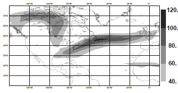
The figure above shows the wind magnitude (m/s) at 250 hPa at 1200UTC 19 December
1999 computed using operational analyses.
In this study, we focus on the likely relationship between the exceptional features of this jet stream and some heavy precipitation that occurred over Central America during mid-December.
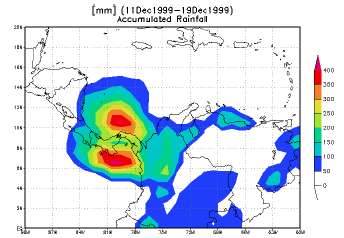
The figure below shows accumulated precipitation (mm) derived from TRMM
data (CDC center) over the Central America between the 11 and 27 December 1999.
Indeed, a Rossby wave train excited by a strong convective activity over this area is likely to play a key role in this teleconnection. To assess this tropical-extratropical interaction, several numerical experiments have been performed with the French global model ARPEGE. Firstly, the effects of convection have been neutralized within a domain localized over Central America. Then, to combine model with observations, a new strategy has been devised.
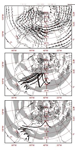
Within a selected window, the parametrized latent heating has been deduced from TRMM precipitation data, translated in terms of a PV source and incorporated into the model using PV inversion. These simulations show, in particular, that the convective activity over Central America triggers a wave train that moves poleward and eastward with the group velocity. Upper-left panel displays 250 hPa wind time average over the 2 last decade of December 1999. 4-day ray path following group velocity starting from different points for wave number k equal to 3 and 5. (from top to bottom). Areas where propagation is allowed, i.e. Ks > k, are blanked. The dispersion relation exhibited using the linearized form of the barotropic vorticity equation is :
w= Uk − (B - d2U/dy2)k / K2
where K = (k2 + l2)1/2 is the total wave number. Stationary waves (w = 0, c = 0) may exist for westerly flows and
positive absolute vorticity gradient in y direction when
K = Ks and therefore with k larger than
Ks =(B - d2U/dy2)/U.
For stationary waves, once k is fixed l is determined using the latter expression for Ks function of the vorticity gradient and zonal wind of the flow. The energy of a wave packet moves with the group velocity defined by the two following components :
ug = 2U k2/Ks2
vg = 2U kl/Ks2
Rossby ray paths are given by dy/dx = vg/ug = l/k =(K2s /k2 − 1)1/2.
The wave train that moves poleward and eastward with the group velocity finally strengthens the North Atlantic jet stream leading to Lothar and Martin .
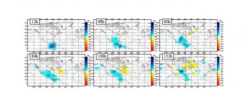
From left to right and top to bottom the figure shows 250 hPa geopotential difference between REF and NOCONV experiment normalized by the norm d(t) = 1.2exp(t/61.7). Solid lines stand for wind magnitude in REF runs at 250 hPa (only 50, 60, 70 m/s are shown).
|