 Mail To:
Last updated
30/06/2007
|
 |
Mean emissivity atlases
computed using
observations from different sensors are ready to be downloaded.
Best-fit coefficients have also been derived from AMSU-A and AMSU-B
observations to model, at a global scale, the emissivity variation with
scan angle and frequency.
This section will be updated frequently in order to add more emissivity
products. Researchers are invited to send their request and/or their questions about
the land emissivity products to F. Karbou.
Important notice
- emissivity maps are gridded emissivities (0.5°x0.5°) and are provided using the netcdf format
- Microwave land emissivities are calculated only if the net
atmospheric transmission is greater than 0.5. This condition is more
easily satisfied for low frequencies (19 to 37 GHz) than for high
frequencies (89, 150 GHz). Consequently, data emissivity gaps are
likely to occur.
- This page will be frequently updated in order to add emissivity data.
- Other data sets are available under request:
- Non gridded emissivities
- emissivity maps with day-to-day variabilities
- emissivity correlation coefficients
- More emissivity estimates will be ready for download by September 2007
| Sensor |
Periods |
Description |
Preview |
Download data |
| AMSU-A |
Several months in 2005, 2006
and 2007 |
mean emissivities at high and
low angles |
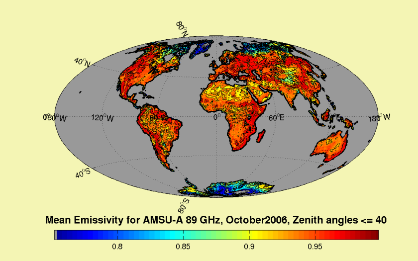 |
GET_DATA |
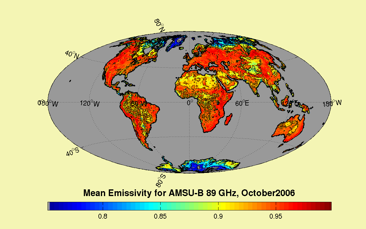
| AMSU-B |
Several months in 2005, 2006
and 2007 |
mean emissivities at high and
low angles
Gaps are likely to occur due to atmospheric transmission lower than 0.5 |
|
GET_DATA |
| SSM/I |
Several months in 2005, 2006
and 2007 |
mean emissivities at high and
low angles
Gaps are likely to occur due to atmospheric transmission lower than 0.5 |
|
GET_DATA |
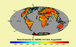
| SSMI/S |
August 2006 |
mean emissivities at window channels |
 |
GET_DATA |
| TMI |
August 2006 |
mean emissivities at window channels |
 |
GET_DATA |
| AMSRE |
August 2006 |
mean emissivities at window channels |
 |
GET_DATA |
AMSU-A
Frequencies: 23, 31, 50 and 89 GHz. Maps are
separated by zenith angle classes: high zenith angles (>40°)
and low zenith angles (< 40°). NO_DATA_VALUES=-1
| Year |
month |
Status |
File |
| 2007 |
April |
Available soon |
--- |
|
March |
Available |
ATLAS_AMSUA_LOW-ANGLES_MARCH2007.cdf
ATLAS_AMSUA_HIGH-ANGLES_MARCH2007.cdf
|
|
February |
Available |
ATLAS_AMSUA_LOW-ANGLES_FEBRUARY2007.cdf
ATLAS_AMSUA_HIGH-ANGLES_FEBRUARY2007.cdf
|
|
January |
Available soon |
--- |
| 2006 |
December |
Available soon |
---
|
|
November |
Available soon |
---
|
|
October |
Available |
ATLAS_AMSUA_LOW-ANGLES_OCTOBER2006.cdf
ATLAS_AMSUA_HIGH-ANGLES_OCTOBER2006.cdf
|
|
September |
available soon |
---
|
|
August |
available soon |
---
|
|
July |
available soon |
---
|
|
June |
available soon |
---
|
|
May |
available soon |
---
|
|
April |
available soon |
---
|
|
March |
available soon |
---
|
|
February |
available soon |
---
|
|
January |
available soon |
---
|
| 2005 |
September |
Available |
---
|
|
August |
Available |
---
|
|
April |
Available |
ATLAS_AMSUA_LOW-ANGLES_APRIL2005.cdf
ATLAS_AMSUA_HIGH-ANGLES_APRIL2005.cdf
|
|
March |
available soon |
---
|
AMSU-B
Frequencies: 89 and 150 GHz. Maps are
separated by zenith angle classes: high zenith angles (> 40 °)
and low zenith angles (<= 40°). NO_DATA_VALUES=-1
| Year |
month |
Status |
File |
| 2007 |
April |
Available soon |
--- |
|
March |
Available |
ATLAS_AMSUB_LOW-ANGLES_MARCH2007.cdf
ATLAS_AMSUB_HIGH-ANGLES_MARCH2007.cdf
|
|
February |
Available soon |
---
|
|
January |
Available soon |
--- |
| 2006 |
December |
Available soon |
---
|
|
November |
Available soon |
---
|
|
October |
Available |
ATLAS_AMSUB_LOW-ANGLES_OCTOBER2006.cdf
ATLAS_AMSUB_HIGH-ANGLES_OCTOBER2006.cdf
|
|
September |
available soon |
---
|
|
August |
available soon |
---
|
|
July |
available soon |
---
|
|
June |
available soon |
---
|
|
May |
available soon |
---
|
|
April |
available soon |
---
|
|
March |
available soon |
---
|
|
February |
available soon |
---
|
|
January |
available soon |
---
|
| 2005 |
September |
Available soon |
--- |
|
August |
Available soon |
---
|
|
April |
Available |
---
|
|
March |
available soon |
---
|
SSM/I
Frequencies: 19(V&H), 22V, 37 (V&H), 85 (V&H). NO_DATA_VALUES=-1
| Year |
Month |
Status |
File |
| 2006 |
October |
Available |
ATLAS_SSMI_OCTOBER2006.cdf |
|
August |
Available |
ATLAS_SSMI_AUGUST2006.cdf |
| 2005 |
September |
Available |
ATLAS_SSMI_SEPTEMBER2005.cdf |
|
August |
Available |
ATLAS_SSMI_AUGUST2005.cdf |
SSMI/S
Frequencies: 19(V&H), 22V, 37 (V&H),50V, 91 (V&H). NO_DATA_VALUES=-1
| Year |
Month |
Status |
File |
| 2006 |
August |
Available soon |
--- |
TMI
Frequencies: 10(V&H), 19 (V&H),21V, 37 (V&H), 85 (V&H). NO_DATA_VALUES=-1
| Year |
Month |
Status |
File |
| 2006 |
August |
Available |
ATLAS_TMI_AUGUST2006.cdf |
AMSRE
Frequencies: 6(V&H), 10 (V&H), 18 (V&H), 23 (V&H), 36 (V&H). NO_DATA_VALUES=-1
| Year |
Month |
Status |
File |
| 2006 |
August |
Available |
ATLAS_AMSRE_AUGUST2006.cdf |
Coefficients for Best-fit functions to model
the AMSU-A and AMSU-B emissivity variation over 18 surface types, with the zenith angle and
the frequency. The surface types have been identified using the BATS climatologie. The coefficients may be used with or without a near-nadir AMSU climatologie. These functions could also be adapted
(under request) to derive AMSU-A or AMSU-B like emissivities using an
SSM/I emissivity climatologie (53° of zenith angle). The
coefficients have been derived from global data.More details about the land emissivity model are given in the "emissivity modelling" section.
The file format is ASCII: Channel_index (For AMSU-A 1:23 GHz, 2:31 GHz, 3:50 GHz, 4:89 GHz and for AMSU-B 1:89 GHz, 2: 150 GHz), surface type, coef1, coef2, coef3, coef4, coef5, coef6. Coefi (1:6) are the coefficients for the emissivity polynomial best-fit function.
The model coefficients computed using data from many months in 2005, 2006 and 2007 will be ready for download by september 2007.
|
|