Section 1
March 2000 - 28 February 2001
Web Page: http://www.cnrm.meteo.fr/gcss/EUROCS/EUROCS.html
1.1
Objectives
The project mainly aims to improve the treatment of cloud systems in global and regional climate models, which directly relates to the RTD priority 2.1.3 "improved model treatment of physical processes (in particular clouds)." In addition, benefits will also be gained for hydrology and severe weather issues (RTD 1.5.2 "Improved flood and drought forecasting").
Clouds probably remain the largest source of uncertainty affecting evaluations of climate change in response to anthropogenic change. That explains for a large part why the range of simulated temperature changes in response to a CO2 doubling (1.5 to 4.5 C) is quite invariant for almost 20 years (e.g. Report of Intergovernmental Panel on Climate Change: Dickinson et al. 1996). The recent interest to develop capability to predict regional climate changes stress the importance to better represent clouds in models. For example, the prediction of distributions of mean and extreme precipitation is highly dependent on the cloud representation in models. The climate community must thus give more consideration to the problem of cloud representation in General Circulation Models (GCMs) and Limited Area Models (LAMs) which are applied to climate issues. As most of European models applied to climate issues are also used to produce short and medium range forecasts, prediction of severe weather systems will directly benefit from EUROCS.
EUROCS concentrates its efforts on 4 major and well identified deficiencies of climate models in representing clouds:
· stratocumulus over ocean
· diurnal cycle of cumulus
· diurnal cycle of precipitating deep convection over continents
· sensitivity of deep convection development on the moisture profile.
These issues (identifying our 4 case studies) are considered of great magnitude as they lead to major deficiencies in the predicted global and regional climates. Some of these issues have been addressed in the past, but others as of yet have not.
The specific aims of the project are:
· To produce comprehensive 4-D data sets using several and Large Eddy Simulations (LES) and Cloud Resolving Models (CRMs) on cases defined above which address critical problems associated with the prediction of cloud in regional and global climate and Numerical Weather Prediction (NWP) models.
· To use the LES/CRM data sets to investigate deficiencies in climate and NWP models using 9 different Single Column Models (SCMs) as a test bed. Specific issues to be addressed will be the general failure of climate regional and global models to predict stratocumulus amounts, the diurnal triggering of boundary layer convection and deep precipitating convection over land, and the lack of sensitivity of deep convection development on moisture profile in these models. Once the reasons of deficiency are identified, physically-grounded corrections will be brought in SCMs.
· To improve climate and NWP models ability to represent both the mean structure (horizontally and vertically) and time variability of cloud water and cover for the critical cases defined above. Six different European climate models will be used in EUROCS making it of large benefit to the whole community.
· To bring together a critical mass of the scientific community across Europe working in various areas of Cloud and Climate research, with the focused aim of improving cloud representations in climate and NWP models.
1.2
Participants and their modeling plans
The strategy used in EUROCS to address these issues is based on the use of a hierarchy of models and observations to integrate cloud studies across the full range of scales. Numerical models range from regional and general Climate Models (CMs) through Single Column models (SCMs) to Cloud Resolving Models (CRMs) and Large Eddy Simulations (LES). Observations collected will vary from global satellite measurements to local observations of individual clouds through lidar and millimetric radars. Table 1.1 illustrates how the ten participants are involved in various aspects of this research by listing the models they are using.
Table 1.1 Partners and model involvement.
|
Partners |
CRM/LES |
SCM |
CM |
|
CNRM-GAME |
Yes |
Yes |
Yes |
|
ECMWF |
No |
Yes |
Yes |
|
UKMO |
Yes |
Yes |
Yes |
|
IMAU |
Yes |
Yes |
No |
|
INM |
Yes |
Yes |
No |
|
SMHI |
No |
No |
Yes |
|
LMD |
No |
Yes |
Yes |
|
MPI |
Yes |
Yes |
Yes |
|
KNMI |
Yes |
Yes |
No |
|
UL |
No |
Yes |
No |
1.3
Milestones
To date, the project is on task and progressing as expected. Table 2 lists the deliverables as set up by the project. The expected date and whether that deadline was achieved is noted.
Table 1.2 Project deliverables and current status.
|
Target Date |
Deliverables |
Status |
|
April 2000 |
D1 - Choice and organization of observations of stratocumulus case to initialize and evaluate SCMs and LES D2 - Choice and organization of observations of diurnal shallow convection case to initialize and evaluate SCMs and LES D3 - Choice and organizations of observations of diurnal deep convection case to initialize and evaluate SCMs and CRMs |
Done Done Done |
|
June 2000 |
D4 - Coice of idealized deep convection case with different mid-tropospheric vapor profiles to initialize SCMs and CRMs |
Done |
|
February 2001 |
D5a - Reference simulation with LES of stratocumulus case and inter-comparison with observations |
Done |
|
August 2001 |
D5b - Ensemble simulations to study the sensitivity to initial conditions and forcings |
On task |
|
February 2001 |
D6a - Simulation with LES of diurnal Shallow convection case and inter-comparison with observations |
Done |
|
August 2001 |
D6b - Ensemble simulations to study the sensitivity to initial conditions and forcings |
On task |
|
February 2001 |
D7a - 2D simulation with CRMs of diurnal deep convection case and inter-comparison with observations |
Done |
|
June 2001 |
D7b - 3D simulation with CRMs of diurnal deep convection case and inter-comparison with observations |
On task |
|
February 2001 |
D8 - Simulations of idealized deep convection studying the sensitivity to mid-trospheric humidity |
Done |
|
February 2001 |
D9 - First drafts of articles on EUROCS activity on CRM |
Underway |
|
May 2001 |
D10 - Dataset from LES runs for stratocumulus case to evaluate and to improve SCMs D11 - Dataset from LES runs for diurnal shallow convection case to evaluate and to improve SCMs |
On task On task |
|
May 2001 |
D12a - Dataset from 2D CRM runs for diurnal deep convection case to evaluate and to improve SCMs |
On task |
|
August 2001 |
D12b - Dataset from 3D CRM runs for diurnal deep convection case to evaluate and to improve SCMs |
On task |
|
May 2001 |
D13 - Dataset from CRM run for idealized deep convection case to evaluate and to improve SCMs |
On task |
|
February 2002 |
D14 - Improvement of cloud and boundary layer parameterizations with SCMs to represent stratocumulus D15 - Improvement of cloud and boundary layer parameterizations with SCMs to represent diurnal shallow convection D16 - Improvement of deep cloud parameterizations with SCMs to represent diurnal variations of deep convection D17 - Improvement of deep cloud parameterizations with SCMs to represent effect of various mid-tropospheric humidity profiles D18 - Comparison of characteristics of stratocumulus, diurnal cycle shallow and deep convection as simulated by current GCMs, LAM and available satellite observations D19 - Drafts of articles on EUROCS activity on CRMs and SCMs |
|
|
April 2002 |
D20 - Implementation of improved cloud schemes in GCMs |
|
|
August 2002 |
D21 - Climate runs with improved cloud schemes in GCMs |
|
|
October 2002 |
D22 - New SCM runs in using CRM datasets to fix new potential problems in climate runs with improved cloud schemes in GCMs |
|
|
Dec. 2002 |
D23 - New climate runs with last improvements in cloud representations |
|
|
February 2003 |
D24 - Comparison of characteristics of stratocumulus, diurnal cycle shallow and deep convection as simulated by improved GCMs, LAM and available satellite observations |
|
|
February 2003 |
Drafts of papers in referee journal describing EUROCS results |
|
1.4
Deviations from Work Plan
The following matrices clearly show the progress being made as regard the case studies. Each case study being explored in this project is represented by an individual matrix that shows which partner is in charge of set-up as well as who all other participating partners are. An X indicates that the data for that model has been collected and disseminated. A date shows the expected time for the data associated with those models. It should be noted that the Climate Model diagnosis will not take place until the final stages of the research.
As can be seen with the matrices, all but one partner was on target. Due to unexpected hiring delays INM were unable to collect their CRM/LES data on time. But this did not interfere with the schedules because results from the three other models being run by other participating partners were sufficient. INM's contribution adds to the data base.
STRATOCUMULUS CASE
|
Group |
Case Set-up |
CRM/LES Runs |
CRM/LES Data Dissemination |
SCM Runs |
SCM Data Dissemination |
CLIMATE MODELS Diagnosis |
|
CNRM-GAME |
|
|
|
X |
May 2001 |
|
|
ECMWF |
|
|
|
X |
May 2001 |
X |
|
UKMO |
|
X |
X |
|
|
|
|
IMAU |
X |
X |
X |
|
|
|
|
INM |
|
May 2001* |
May 2001* |
May 2001 |
May 2001 |
|
|
SMHI |
|
|
|
|
|
|
|
LMD |
|
|
|
X |
X |
|
|
MPI |
|
X |
X |
X |
X |
|
|
KNMI/UL |
|
|
|
X |
X |
|
CUMULUS CASE
|
Group |
Case Set-up |
CRM/LES Runs |
CRM/LES Data Dissemination |
SCM Runs |
SCM Data Dissemination |
CLIMATE MODELS Diagnosis |
|
CNRM-GAME |
|
|
|
|
May 2001 |
|
|
ECMWF |
|
|
|
X |
X |
|
|
UKMO |
|
X |
X |
|
|
|
|
INM |
|
May 2001* |
May 2001* |
X |
X |
|
|
SMHI |
|
|
|
|
|
|
|
LMD |
|
|
|
|
May 2001 |
|
|
MPI |
|
X |
X |
|
May 2001 |
|
|
KNMI/UL |
X |
X |
X |
X |
X |
|
* Due to unexpected hiring delays the CRM runs are currently being performed. The runs are expected to be finished by May 2001. Results will be presented at the Lisbon Workshop.
Diurnal Cycle of Deep Convection
|
Group |
Case Set-up |
CRM/LES Runs |
CRM/LES Data Dissemination |
SCM Runs |
SCM Data Dissemination |
CLIMATE MODELS Diagnosis |
|
CNRM-GAME |
X |
X |
X |
|
May 2001 |
|
|
ECMWF |
|
|
|
X |
X |
|
|
UKMO |
X |
X |
X |
|
May 2001 |
|
|
INM |
|
|
|
|
May 2001 |
|
|
SMHI |
|
|
|
|
|
|
|
LMD |
|
|
|
X |
May 2001 |
|
Idealized Humidity Case
|
Group |
Case Set-up |
CRM/LES Runs |
CRM/LES Data Dissemination |
SCM Runs |
SCM Data Dissemination |
CLIMATE MODELS Diagnosis |
|
CNRM-GAME |
|
|
|
|
May 2001 |
|
|
ECMWF |
|
|
|
|
May 2001 |
|
|
UKMO |
X |
X |
X |
X |
X |
|
|
INM |
|
|
|
|
May 2001 |
|
|
SMHI |
|
|
|
|
|
|
|
LMD |
|
|
|
X |
May 2001 |
|
Section
2
|
Contract n° |
EVK2-CT-1999- 00051 |
Reporting period: |
March 2000 – February 2001 |
|
Title |
EUROCS : EUROPEAN PROJECT on
CLOUD SYSTEMS in CLIMATE MODELS |
||
|
Objectives: EUROCS aims to improve the treatment of cloud systems in global and regional climate models. In addition, benefits will also be gained for hydrology and severe weather issues. Clouds probably remain the largest source of uncertainty affecting evaluations of climate change in response to anthropogenic change. The recent interest to develop capability to predict regional changes of climate, stresses the importance of better representing clouds in models. EUROCS concentrates its efforts on 4 major and well identified deficiencies of climate models: stratocumulus over ocean, diurnal cycle of cumulus, diurnal cycle of precipitating deep convection over continents, and sensitivity of deep convection development on the moisture profile. These issues are considered of great magnitude as they lead to major deficiencies in the predicted global and regional climates. The strategy used to address these issues is based on the use of a hierarchy of models and observations to integrate cloud studies across the full range of scales. Numerical models range from General Circulation Models (GCMs) through Single Column models (SCMs) to Cloud Resolving Models (CRMs) and Large Eddy Simulations (LES). Scientific achievements
General achievements-The choice and organization of observations to
initialize and evaluate SCMs and LES have been achieved for: stratocumulus,
diurnal shallow convection, diurnal deep convection, and idealized deep
convection cases with different mid-tropospheric vapor profiles. -Reference simulations with LES of stratocumulus and cumulus cases and inter-comparison with observations have been successfully performed. -Two-dimensional simulation with CRMs of diurnal deep convection and inter-comparison with observations and simulations of idealized deep convection studying the sensitivity to mid-tropospheric humidity have been successfully performed -Preliminary analysis of simulations with SCMs on each case study have
allowed to identify quite general deficiencies in standard cloud schemes.
That demonstrates that the setup of cases is well suited to address the major
issues of climate models in representing clouds.
Detailed achievementsi) Stratocumulus case The LES models all capture the strong diurnal variation in liquid water path, the observed turbulence profiles and clearly show a decoupled boundary layer during daytime and a well-mixed boundary layer during the night. The diurnal variation in boundary layer properties leads to a strong diurnal variation in the surface fluxes, an effect which will be analysed in detail in combination with the SCM and GCM results.
Preliminary results from three SCMs have been compared with the
observations and LES results. Two
SCMs predict a too low liquid water
path during the night and one predicts a rather large liquid water path but
with a timing out of phase compared with the observations.
ii)Cumulus case
The LES models are capable of reproducing realistically the diurnal
cycle in the presence of shallow cumulus clouds. LES models do behave
similarly and give approximately the
same timing as the observations for the onset and offset of the clouds. The
cloud cover amount reaches about the same maximum value as observed. The
diurnal variation of cloud base height is similar to observations
(ceilometer). The sub-cloud layer structure seems hardly affected by the
clouds on top, meaning that the issue of the parameterization is less
complicated. Most SCMs produce a total cloud cover of
50-60%, in contrast to the 25% in the LES results. The integrated liquid
water path is consequently also high (2-5 times too large). In addition,
neither of the SCMs produces a realistic diurnal cycle, in particular the
clouds remain after sunset. iii)Diurnal deep
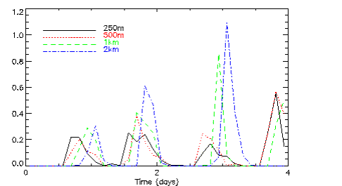
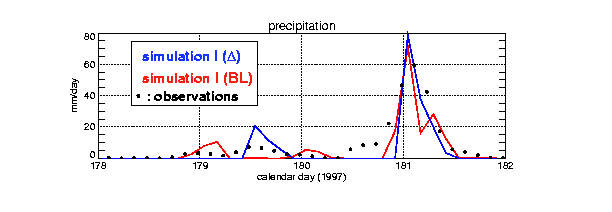
convection A first survey of GCMs involved in EUROCS have shown that deep convection frequently occurs too early in the daytime. Results from CRMs showed that they compare reasonably well with observations. However, it was difficult to predict the exact occurrence of precipitating events. This type of simulation involves strong interactions with surface and boundary layer processes, i.e. processes that occur on smaller scales than deep convection and thus may not be well resolved by CRMs. Sensitivity tests to the horizontal resolution (from 2km to 250m) have shown that the timing of rainfall and cloud cover is sensitive to these parameters but with an evidence of convergence of results for high resolution . This sensitivity to the resolution could be explained by turbulent flux differences in the boundary layer. The timing of precipitation was also found to be sensitive to the turbulent scheme. These two results suggest that a proper CRM simulation of deep convection over land require high horizontal resolution and/or an advanced turbulent scheme. Preliminary
results of two different SCMs have shown that precipitation occurs too early.
These results suggest that this weakness shared by GCMs, could be properly
analyzed within the joint CRM/SCM framework. iv) Sensitivity to
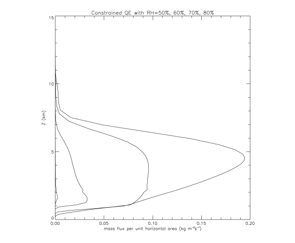
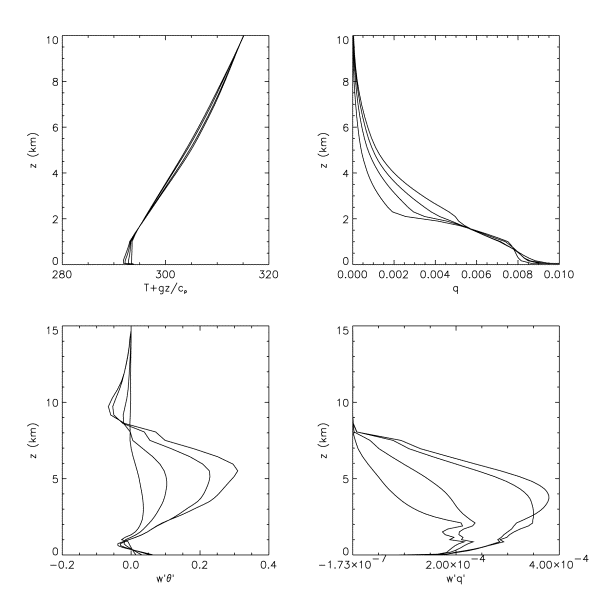
humidity profile A CRM pilot run have confirmed that changes in the mid-tropospheric humidity can switch the convection regime between shallow non-precipitating convection and vigorous deep convection, with changes to the shape of the convection profiles as well as the magnitude and depth. For the formal inter-comparison of models there is also a clear trend for stronger convection in the moister cases, which pushes the temperature profile closer to the moist adiabat. Despite the differences in magnitude and profile shape, the depth of convection was almost the same in all the cases. The CRM simulations converge rapidly to a quasi-steady convective ensemble. To compare
with the pilot CRM, a simple SCM was used. It is based on a highly-simplified
plume model, including an "ensemble" option resembling the
Arakawa-Schubert ensemble. The ensemble version matches the shapes of the CRM
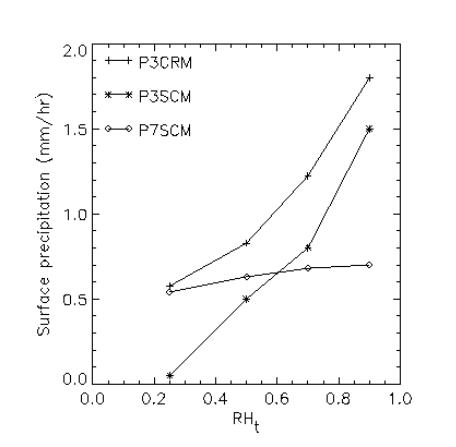
profiles more closely than does the standard single-plume version. Significant variations are found in
surface precipitation as a function of humidity, and between different SCMs
and the CRM. These differences require further analysis but show the
potential of this approach to test the schemes. Socio-economic relevance
and policy implications The
economic and social impacts of this project will result in the expected
improvements in cloud parameterizations. In improving cloud
parameterizations, we would improve cloud and precipitation events of
importance to human activities, such as agriculture, transport, some kinds of
industry, as well as the atmospheric pollution forecast which depends on the
ability to make precise weather forecasts. The study on the deep convection
case should also contribute to improve the forecast of summer convective
systems. Heavy precipitation and severe flood events associated with these
systems are recognized as a threat to social and economic life in many
regions of Europe. Conclusion At the end
of the first year, the project is on the right track and on time. The choice
of case studies with the observations to initialize and evaluate all the
hierarchy of models has been achieved. Reference simulations with explicitly resolved cloud models have been successfully performed. Preliminary analysis of simulations on each case study has led to the identification of quite general deficiencies in standard cloud schemes used in climate models. This point was considered crucial as it demonstrates that the se-up of cases is well suited to address the major issues of climate models in representing clouds. Because the
EUROCS programme constitutes the largest European contribution to GEWEX Cloud
System Studies (GCSS is a non-funded programme of WCRP), EUROCS has been active and influential in
a co-ordinated
manner within GCSS. Keywords: CLOUDS, CLIMATE, PRECIPITATION, BOUNDARY LAYER |
|||
Section
3
STRATOCUMULUS OVER THE
OCEANS
Gathered and Prepared by:
Peter G. Duynkerke, Margreet C. van Zanten and Arjan van Dijk
Case Leader: IMAU
Participating Partners: CNRM-GAME, ECMWF, UKMO, INM, SMHI, LMD, MPI, KNMI, and
UL
WEB Page: http://www.phys.uu.nl/~wwwimau/EUROCS/eurocs_art.html
3.1
Motivation
The primary objective of EUROCS is to improve the treatment of cloud systems in general circulation models (GCMs) and regional circulation models (RCMs). The present research focuses on the representation of stratocumulus over the ocean in these three-dimensional models. This report section addresses the full diurnal cycle of stratocumulus off the coast of California based on observations of the First ISCCP (International Satellite Cloud Climatology Project) Regional Experiment (FIRE).
The extensive areas of sub-tropical marine stratocumulus clouds off the West coast of large continents lie beneath the descending branch of the Hadley circulation. The large static stability associated with the cold sea-surface temperatures (SSTs) and atmospheric subsidence results in extensive marine stratocumulus cloud decks with an areal coverage of about 40 - 90%. Due to their high albedo, these stratocumulus decks have a significant cooling effect on the underlying ocean. This cooling is only slightly offset by the downward infrared emission from the cloud.
In atmospheric GCMs, however, the amount of subtropical marine stratocumulus is usually under predicted, even when the observed SSTs are prescribed (Jakob, 1999). As a result, in such models the net surface heat flux into the ocean is overestimated in these regions. In a coupled atmosphere-ocean model this can lead to positive SST biases of about 5K. It is now well established that these model errors have a significant influence on the (sub) tropical circulations (Philander et al., 1996; Ma et al., 1996; Nigam, 1997). Furthermore, the stratocumulus cloud cover can act as feedback (or a “thermostat”) which reduces the intensity of tropical convection and damps the tropical circulation as a whole (Miller, 1997). Therefore, it is vitally important to consider the full life cycle of stratocumulus.
The goal of this study is to assess the quality of the representation of stratocumulus in the GCM (weather and climate) and RCM models. We will therefore perform an intercomparison between FIRE I observations and model results. The FIRE I experiment (Albrecht et al., 1988) provided a comprehensive observational set of data on marine stratocumulus on San Nicolas island (SNI) during July 1987. These observations will be used in LES and SCM simulations to study the diurnal variation of stratocumulus (section 3.3 and 3.4). Moreover, cloud parameters (Minnis et al., 1992; Rossow and Schiffer, 1999) derived from satellites will be used to verify the representation of stratocumulus in GCMs and RCMs over a larger region (section 3.5). We will focus on the monthly-mean diurnal variation and monthly mean values of cloud parameters and surface energy balance.
In Duynkerke and Teixeira (2001) the ECMWF Re-Analysis (ERA) results for July 1987 are compared with stratocumulus observations for the same period made during the FIRE I experiment. They concluded that the ERA cloud thickness is overestimated and cloud cover and liquid water path are strongly underestimated compared with the FIRE I observations. As a result the ERA downwelling shortwave radiation at the surface is much larger than observed. They argued that the large difference between the ERA downwelling shortwave radiation at the surface and that observed in FIRE I can lead to large biases in the sea-surface temperature in a coupled ocean-atmosphere model. Therefore, this study focuses on representation of the diurnal variation of cloud properties (boundary layer depth, liquid water path, optical depth, etc.), surface energy balance and implications for a coupled atmosphere-ocean model, turbulence dynamics (entrainment, decoupling, etc.) in the boundary layer, and shortwave optical properties of inhomogeneous 3-dimensional cloud fields.
3.2
Case Description
3.2.1 Surface
based observations
The FIRE I experiment (Albrecht et al., 1988) provided a comprehensive observational set of data on marine stratocumulus during July 1987. From the observations the following parameters will be used: cloud cover, liquid water path, cloud-base and cloud-top height, and downwelling shortwave and longwave radiation at the surface (Duynkerke and Teixeira, 2001).
A description of the temporal evolution of the cloud conditions on San Nicolas Island during July 1987 can be found in Blaskovic et al. (1991), Betts (1990) and Albrecht et al. (1990). Hignett (1991) describes the detailed turbulence profiles throughout the boundary layer, taken on 14 and 15 July 1987. These turbulence data have been successfully modelled with a 1.5-order turbulence closure scheme (Duynkerke and Hignett, 1993). The overall picture is of a cloud layer that progressively thins during the late morning into the afternoon, both by raising cloud base and lowering the inversion, but that thickens again during the evening.
3.2.2 Satellite observations
Betts et al. (1992) and Minnis et al. (1992) have derived cloud parameters from the Geostationary Operational Environmental Satellite (GOES). Figure 3.1 shows the low-cloud faction derived from GOES data over the Extended Time Observations (ETO) area (Betts et al., 1992) for July 1987. The ETO data were analysed on a 2.5o latitude-longitude grid covering the area between 10o - 40o N and 110o - 145o W. Minnis et al. (1992) analysed the data on finer grids: a 1o and 0.33o latitude-longitude grid, respectively. They compared the satellite derived values, on the 0.33o latitude-longitude grid, with observations performed on San Nicolas Island. They concluded that the diurnal variation of satellite retrieved values of cloud amount, optical depth and cloud-top height shows very good agreement with the surface-based observations on San Nicolas island. The satellite data of Betts et al. (1992) and Minnis et al. (1992) were thus verified at SNI and this data will now be used over the ETO region to verify the GCM and RCM predictions (section 3.5).
3.2.3 Large
Eddy Simulations and Single Column Model Simulations
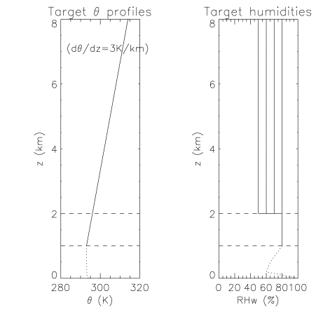
The LES and SCM model simulations were started on 14 July 0800 UTC (= 00 LT) lasting at least 37 hours (37 LT). The initial and boundary conditions were based on the observations described in Blaskovics et al. (1991), Hignett (1991), Duynkerke and Teixeira (2001). Both LES and SCM use the same initial conditions and vertical resolution. From the measured potential temperature and specific humidity profiles the initial potential temperature and humidity profiles were determined. The goal is to simulate as closely as possible the typical monthly-mean diurnal variation. Therefore the initial conditions were not
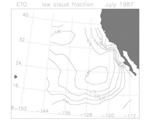
Figure 3.1 Mean low-level cloud cover for July 1987 from GOES for the ETO region.
exactly tuned to the conditions on 14 July 1987 but were more representative of the monthly-mean conditions.
3.3
Large Eddy Simulation results
We have received LES results from 3 out of the 4 models. All three models have simulated the case defined and have performed sensitivity simulations with respect to sea-surface temperature, inversion properties, long wave radiative heating at cloud base and grid resolution. In Figure 3.2 we have compared the liquid water path of the three LES models with the observed values. The observed values are the hourly-mean values during 14 and 15 July 1987 (denoted as 0 to 48 hours) and the hourly monthly-mean diurnal variation. The LES models all capture the strong diurnal variation in LWP due to the forcing imposed by the shortwave heating of the cloud layer. The UKMO model has more liquid water because the model generates less entrainment of warm and dry air from above the inversion into the boundary layer. The LES results are also compared with the turbulence profiles observed by Hignett (1991) and clearly show a decoupled boundary layer during daytime and a well-mixed boundary layer during the night. The diurnal variation in boundary layer properties leads to a strong diurnal variation in the surface fluxes, an effect which will be analysed in detail in combination with the SCM and GCM results.
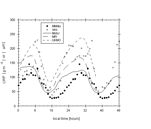
Figure 3.2 The observed and modelled liquid water path (LWP)
as a function of time for 14 and 15 July 1987 (denoted from 0 to 48 hours). The
open circles are the hourly mean observed values whereas the filled dots are
the hourly monthly-mean values. The LES results are from IMAU (full line), MPI
(long dashed) and UKMO (short dash).
3.4 Single Column Model results
Results from three SCM have been disseminated and have been compared with the observations and LES results. The SCM include the KNMI, LMD and MPI model. In Figure 3.3 the liquid water path (LWP) of the three SCMs is compared with the observed values. The KNMI and LMD model predict a too low liquid water path during the night (24 hours). The MPI model predicts a rather large liquid water path. Further analyses of the SCMs will be performed when all results have disseminated.
3.5 Climate Model simulations
In order to make an inventory of the quality of General Climate Models (GCMs) and Regional Climate Models (RCMs) we will collect the data of present day models and compare these with the SNI and satellite data. The GCM model can be either a climate model or a weather-forecast model. The models have to simulate July 1987 and output has to be supplied over the ETO region: between 10o - 40o N and 110o -145o W. The output should be given at the model resolution. We will focus on the monthly-mean diurnal variation of the surface energy balance and cloud properties. Moreover, we will document the vertical structure of the boundary layer over the ETO region. At the moment we have the data from the ECMWF model and we have started analysing the results. Figure 3.4 shows the monthly mean low cloud cover from the ECMWF model. This can be compared with the observed cloud cover retrieved from a satellite as shown in Figure 3.1. From a comparison of Figures 3.1 and 3.4 it can be concluded that the ECMWF model is under predicting the cloud cover by about 20%. In the future we will perform a more detailed analysis as was done for ERA in Duynkerke and Teixeira (2001).
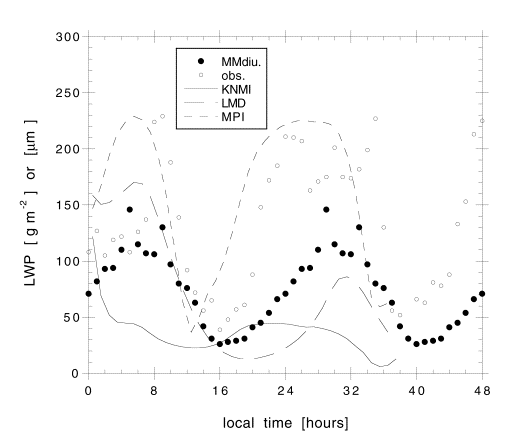
Figure 3.3 The same as Figure 3.2 but the lines are now SCM
results: KNMI (full line), LMD (long dash) and MPI (short dash).
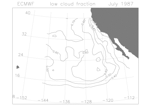
Figure 3.4 Mean ECMWF low-level cloud cover for July 1987 for the ETO region.
4.6
Conclusions and future work
Most LES results are now available and analysed. The results will be available on the world-wide-web in the near future. With the LES models, sensitivity simulations have been performed to the sea-surface temperature, inversion properties and grid resolution. New sensitivity simulations will be performed with respect to subsidence and wind shear at the inversion. Moreover, LES simulations will be performed on a large domain (tenths of kilometres) and a case will be set up to study the transition of stratocumulus into cumulus. Results of three SCMs have been disseminated and have been compared with the LES results and observations. The SCMs should perform sensitivity analysis with respect to different boundary conditions, forcings and vertical resolutions. All other SCM results should be submitted before the workshop in Lisbon from 28 to 31 May 2001. At the time of this workshop most SCM and GCM results should be analysed.
Section
4
DIURNAL CYCLE OF SHALLOW CUMULUS OVER LAND
Gathered and Prepared by:
A. P. Siebesma and G.
Lenderink
Case Leader: KNMI
Participating Partners: UL, CNRM-GAME, ECMWF, UKMO, INM, SMHI, LMD, and MPI
WEB Page: http://www.knmi.nl/samenw/eurocs/ARM/
4.1 Introduction and Motivation
Underestimation and an inadequate phase of the diurnal cycle for cloud cover over land are known to occur in climate and weather numerical models. This can have dramatic consequences on the behaviour of the boundary layer. During summer seasons, diurnally driven boundary layer clouds are commonly seen over continental regions and play a crucial role in determining the surface energy budget. On a given day failure to capture the variation of shallow cumulus clouds adequately, may lead to errors in predicted surface temperature and moisture and so contribute to failures of predicting the onset of more vigorous deep convection. On seasonal timescales, persistent biases in the surface radiation budget can lead to systematic errors in continental scale hydrological budgets which are important for predicting impact of seasonal and anthropogenic climate variability. Using the strategy of a hierarchy of models and observations such as pointed out in the EUROCS proposal we will present the intermediate results on the above raised issues.
4.2 Case description
The case was released on the internet http://www.knmi.nl/samenw/eurocs/ARM/ early September 2000. It is based on the one originally set up by Andy Brown (UK Met. Office) and is composed on observations made at the Southern Great Plains (SGP) ARM site on June 21 1997. On this day, cumulus clouds developed at the top of an initially clear convective boundary layer. The large scale forcing was weak compared to the surface forcing. Non-precipitating cumulus clouds started to form around 14:30 UTC (8.30 local) and disappeared at around 23.30UTC (17.30 local). A maximum cloud cover of around 30% was reached. Because this is the first inter-comparison study on the diurnal cycle of cumulus everything is kept as simple as possible but yet realistic. For this reason, surface fluxes, the tendencies due to radiation and large-scale advection, are prescribed all during the simulation. The required simulation starts at 11.30 UTC, just before sunrise with a stable dry boundary layer based on radiosonde observations. The simulation is required to run from 11.30 UTC June 21 throughout the whole day until 2.00 UTC June 22, well after sunset when all the clouds should have dissolved again. For a detailed case description plus the required output we refer to the web address mentioned above.
4.3
Large Eddy Simulation studies
Within the EUROCS framework three groups (MPI, UKMO and KNMI) have submitted LES results. Three important conclusions can be drawn from these results:
· LES models are well capable of reproducing realistically the diurnal cycle of the shallow cumulus topped boundary layer
· Results of previous steady state cases of cumulus over sea still apply to the present case where strong diurnal cycle is present
· The sub-cloud layer structure seems hardly affected by the clouds on top.
Concerning the first conclusion, all three models behaved very
similar. They all transformed an initially stable boundary layer into a
convective dry boundary layer without clouds, developed subsequently a
conditionally unstable layer with clouds and finally, just after sunset slid
back into a stable clear nocturnal boundary layer. Directly related is the correct
timing of the appearance and disappearance of the cumulus clouds as well as the
time evaluation of cloud cover, cloud base height, and cloud top height. In
Figure 4.1 we show the time evaluation of the total cloud cover of the three
LES models. Note that all three models do behave similarly and actually give
approximately the same timing as the observations for the onset and offset of
the clouds. Also the cloud cover amount reaches about the same maximum value as
observed. Cloud base height (not shown here) is for all three models increasing
from about 600m around the onset at 15.00 UTC to 1250m at 23.30 just before the
clouds disappeared. Again these results compare quite well with observational
ceilometer measurements at the central facility at the ARM site.
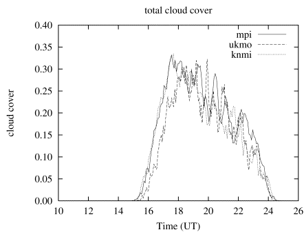
Figure 4.1. Total cloud cover as a function of time of the 3 LES models.
Concerning the second conclusion, previous inter-comparison studies based on BOMEX and ATEX show cloud cover and mass flux profiles that have a maximum value around cloud base and are then monotonically decreasing with height. Furthermore those studies show typical lateral fractional entrainment rates of 1~3 10-2 m-1 and slightly higher fractional detrainment rates. We repeated these calculations for the present case for each model result during each hour of the simulation and found similar results. Note that this is quite an interesting result, since throughout the simulation the mean vertical profiles do change substantially. So apparently these results are robust fingerprints of shallow cumulus that not only occur during controlled steady state conditions but also under fast varying conditions such as the present diurnal cycle.
Finally, concerning the last conclusion it turns out that the sub-cloud layer has quite the same characteristics as the dry convective boundary layer. For instance, the vertical velocity variances sw2 of the three models, when non-dimensionalised appropriate, do exhibit the same behaviour as in the dry convective boundary layer. Similarly the ratio of the minimum buoyancy flux and the surface buoyancy flux is almost all the time from sunset to sundown quite close to –0.2, the same value as found in typical dry convective boundary layers! This means that the top entrainment mechanism and hence the ventilation of moisture and heat into the free atmosphere is not strongly affected by the clouds. The only difference is that in the case of a dry convective boundary layer heat and moisture is deposited in a rather thin entrainment layer while in the case of a cumulus topped boundary layer it is redistributed in a much deeper cloud layer. This finding makes the issue of the parameterization of the cumulus-topped boundary layer much less complicated.
The overall conclusion is that the results of the LES models are such that they can serve as an excellent 4D-dataset that can be used as a test-bed for evaluation and improvement of the parameterizations of these processes in GCMs.
4.4 Single Column Model results
In order to diagnose the results of the parameterizations in various
SCM’s the first step that has been undertaken was to get a good description of the
parameterizations of all the participating GCMs. This necessary step was
initiated in June 2000. At the moment, we have received parameterization
descriptions of the ECMWF, LMD, ARPEGE (CNRM/GAME),, RACMO (KNMI), ECHAM (MPI)
and the Meso-NH (INM and UL) models. A summary of these descriptions can be
found on the web at http://www.knmi.nl/samenw/eurocs/ARM/participant.html. It appears that many
of these models are rather similar in many respects, though on a more detailed
level they differ distinctly. All models have a turbulent diffusion scheme,
attempting to do the mixing in the sub cloud layer and some, if formulated in
moist conserved variables, as well in the cloud layer. Except LMD and ECMWF, all models use a moist
1.5 order turbulence closure. Some models (LMD and ARPEGE) however do not seem
to mix in moist conserved variables and are in this sense inconsistent. Most
models use a (bulk) mass flux scheme to do mixing in the cloud layer. The models differ most with respect to
computation of the cloud fraction and cloud liquid water (the cloud scheme).
The models ranged from prognostic schemes for both cloud liquid water and cloud
fraction to fully diagnostic schemes for both variables.
At
the moment of this writing results were received by following models: ECMWF,
ARPEGE, RACMO and Meso-NH (two versions from INM and UL). However, not all the
requested output was sent in by the participants so a very detailed analysis is
at the moment not possible. This task was in fact scheduled for the second year
in the initial proposal. Nevertheless,
from the first results a rather consistent picture emerges. The results
basically confirm results earlier obtained from inter-comparisons for cumulus
clouds. Most models produce a total
cloud cover of 50-90 %, in contrast to the 25 % in the LES results (see Figure
4.2). The integrated liquid water path, which is shown in Figure 4.3, is
consequently also high (2-5 times the value in the LES models). In addition,
neither of the models produces a realistic diurnal cycle; the clouds remain
after sunset. Except the ECMWF model, they all produce profiles of temperature
and moisture that are too well mixed and the cloud top height is
underestimated. This is a consequence
of the apparent strong activity of the turbulence scheme, producing profiles
close to the well-mixed stratocumulus regime. This indicates that either the
moist mixing in the turbulence scheme is overestimated or the activity of the
mass flux scheme underestimated. Some participants reported that the mass flux
scheme failed to turn on. In this respect, the ECMWF model was the only
exception. In this model, the mass flux scheme seems to be overactive. The
ECMWF produced a very realistic cloud top height,
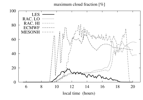
Figure 4.2 Total cloud cover as a
function of time of the single column models (note that the time is local
time).
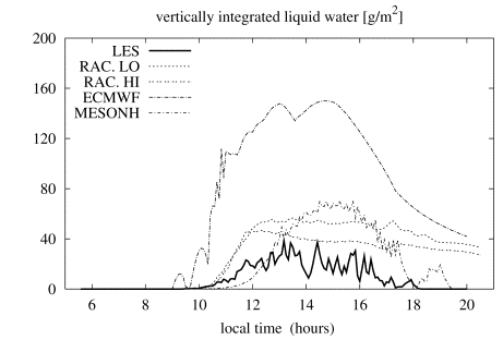
Figure 4.3 Integrated liquid water path
as a function of time of the single column models (note that the time is local
time).
but
overestimated the transport by the mass flux scheme. As a consequence, a too
strong drying and warming near cloud base occurs and a too strong moistening
and cooling near the inversion. This produces a maximum in the cloud fraction
at the inversion; this feature was also observed in the other models - though
for a different reason - and contrast highly with the LES which have maximum
cloud fraction near cloud base.
So
there are at the moment two concluding remarks:
· Concerning
the mixing, it appears that many of the deficiencies are caused by an improper
balance between mixing of the (moist) turbulent scheme and the mixing of the
mass flux scheme. Except the ECMWF model, in all models the turbulence scheme
is too active in the cloud layer. The ECMWF model does the opposite and has a
too active mass flux scheme.
· Concerning
the cloud fraction, all models are strongly overestimating cloud cover and
liquid water paths. Also they collectively fail to dissolve the clouds at the
end of the day.
4.5 Plans for Climate Models
In Section 4.4 of this report, a case for climate model over persistent stratocumulus areas off the coast of California are planned. In addition we plan to do additional climate model runs for the same period over an area more upstream towards the Hawaii Islands where the stratocumulus regime is breaking up into more scattered cumulus fields. As a first step in this direction the ECMWF model will produce output, which will be analysed in spring 2001. Subsequently a prescription for the other participating models will be set up.
4.6
Conclusions and future work
The LES model results compared well enough with the observations in order to be used as 4D Data sets for evaluating parameterization issues. Therefore, not much more additional effort is required on this part. Many of the results found for steady state marine cumulus were reconfirmed by the present case.
For the SCM results, despite the fact that not all requested output was sent in we already identified some quite general deficiencies concerning both the mixing and the clouds. This needs and will be further explored at the next workshop in Lisbon. By this time all required output of the participating SCMs will be analyzed. Special attention will be paid to the vertical resolution since it seems that vertical resolution might play a major role in the results. To this purpose we ask for all SCMs output at three different vertical resolutions: 1) the operational, 2) ECMWF resolution (at present: highest operational resolution) and 3) a very high resolution of effectively 100m.
Further future plans are twofold: Firstly to address the stratocumulus/cumulus issue, we are conceiving a wide range of LES runs in which the initial conditions are varied from typical stratocumulus to cumulus. This can be used for the SCMs tot test whether they are capable of selecting the right cloud type, given the initial conditions. Secondly as mentioned in section 4.5 we are setting up a case for 3D climate models in the trade wind region over the Pacific Ocean.
Section
5
DIURNAL
CYCLE OF DEEP CONVECTION OVER LAND
Gathered and Prepared by:
F. Guichard and J.
Petch
Case Leaders: CNRM-GAME and UKMO
Participating Partners: ECMWF, INM, SMHI, and LMD
WEB Page: http://www.cnrm.meteo.fr/gcss/EUROCS/deepdiurnland.html
5.1 Introduction and Motivation
The diurnal cycle of deep convection plays an important role in the energy and water budgets, both locally and globally. Convectively generated clouds (as any cloud) strongly interact with both solar and thermal infra-red radiation. At night, they contribute to the greenhouse effect by efficiently trapping thermal infra-red radiation so that night time surface temperature is warmer under cloudy conditions. During the day the reflection of insolation generally dominates over the greenhouse effect which has an opposite effect on surface temperature. Therefore, it is important to correctly predict the time of the day during which these clouds are present in order to get an accurate radiative budget, both at the top of the atmosphere and at the surface. Clouds also strongly modulate the magnitude of surface heat fluxes (sensible plus latent) as well as their partition (sensible versus latent) via their radiative impacts and precipitation (a larger part of rainfall is re-evaporated over land in the daytime than during night-time). The diurnal cycle of deep convection is generally stronger over land than over ocean, with a phase difference between oceanic and land areas (Figure 5.1). Convective precipitation exhibits an early morning maximum over open oceans (Gray and Jacobson 1977) but there is no consensus toward a theory explaining this phenomenon (see Parsons et al. 2001 for a review). The situation is somewhat simpler over land where the diurnal cycle of deep convection is strongly linked to daytime boundary layer heating in response to solar radiation, with a maximum of precipitation in the afternoon to early evening.
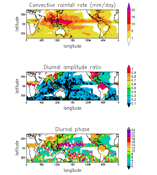
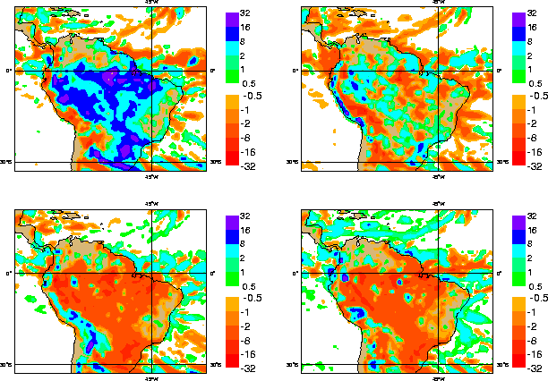
Recent studies have shown that it is difficult for GCMs to capture the diurnal cycle of deep convection, both in terms of magnitude and phase, and over land as well as over ocean convection (Dai et al. 1999, Lin et al. 2000, Royer et al. 2000, Yang and Slingo 2001). Royer et al. (2000), using the CLAUS (Cloud Archive User Service) data set show that the diurnal cycle in their GCM is too weak with precipitation occurring several hours too early as compared to observations (Figsures 5.1 and 5.2). Lin et al. 2000 also show that they can get a reasonable GCM simulation of the diurnal cycle or of the monthly mean, but not both at the same time. As an archetype, the magnitude of the diurnal cycle of convection over South America is the largest in the world (Yagai et al. 2001). In the ECMWF operational model, it corresponds to a large-scale feature over the Amazon region. Figure 5.3 shows the deviation of 6-hour averages of precipitation from the daily total taken from 24 to 48 hour forecasts with the model for 1-7 February1999. The four panels show the rainfall anomaly from the 7-day all-day average for rainfall occurring between 12-18 UTC (8-14 LST, top left), 18-00
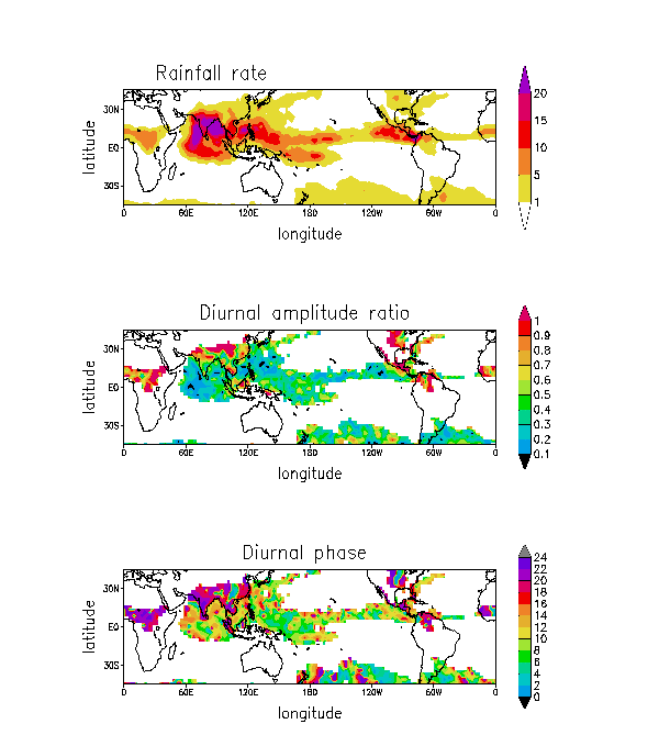
Figure 5.1 Mean convective rainfall for JJA 1992 computed by
applying the DCA index of Hendon and Woodberry to the CLAUS satellite archive
(top : in mm/day), relative amplitude ratio (middle) and phase (bottom : hour
of the maximum in local time) of the first harmonic of its diurnal cycle (from
Royer et al. 2000).