|
The
Fronts and Atlantic Storm-Track Experiment is an atmospheric
science project that focuses on the mid-latitude cyclones that
form and develop over the North-Atlantic ocean and eventually
hit the West Coast of Europe (as illustrated by Fig.A).
These cyclones provide most of northern Europe's resources in
water. They are also, however, responsible for the most damaging
weather over large areas, such as floods and strong winds.
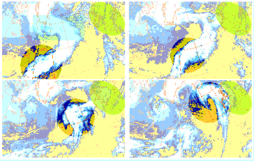
On the long time scales, the Atlantic mid-latitude
cyclones play a key role in shaping the climate of Western Europe.
They are the main rainmakers in this area, and, in close relationship,
they also are the main cloudmakers. Cyclones act within the climate
system both individually and as a population. As the latter,
they strongly interact with the very large scale flow: they contribute
to maintening, for periods of several days to several weeks,
the same large scale pattern and as a result, they travel along
the same track: this observational fact has led to coin the name
``storm-track''.
These periods of continuing weather pattern
are called weather regimes. The storm-tracks are the zones of
most active energy and water exchange in mid-latitudes, hence
their importance in the global climate balance. The activity
of storm-tracks embodies essentially the collective impact of
cyclones. However, cyclones can reach such extreme values in
wind and rain generation that they can, individually, also influence
the longer term evolution: individual events are, for example,
suspected of causing regime transitions.
For the same reason, namely their ability
to generate large winds and rainfalls over large areas for relatively
long times, mid-latitude cyclones are critical to the economy. |
|