8. Malgorzata SZCZECH-GAJEWSKA : "Use of IASI / AIRS observations over land"
The use of very high spectral resolution satellite measurements over land, as given by AIRS or IASI instruments, will certainly increase in the next few years. Preparatory studies have begun with the creation of appropriate "climatological" maps for surface spectral emissivity (SSE). In this report I will present maps of these quantities. Emissivity maps were prepared on the base of the new ECOCLIMAP (Masson et al., 2002) vegetation and land cover types and the infrared SSE values from spectral libraries (MODIS, ASTER and JPL) compiled with the ones modelled by Snyder et al. (1998). New emissivity maps were produced separately for 18 wavebands in the infrared spectral range and for each month. The final maps were validated with MODIS channel 31 and 32 land surface emissivity products based on the "split-window" method. Further validation of this new SSE was performed by quantifying the impact brought by this new emissivity when computing simulated radiances for IR sounder. It was carried out first in the radiative-transfer model RTTOV-7 and High-resolution Infra-Red Sounder (HIRS) channel 8 data. A successive step has consisted in the validation of the emissivity with Atmospheric Infrared Sounder (AIRS) measurements. Extensive tests of the SSE with the AIRS data are currently performed. Additionally, preliminary experiments with emissivity as a control variable in a 1-dimensional variational assimilation model (1D-Var) have been run.
The new classification of surface types was based on ECOCLIMAP, a complete surface parameter global dataset (Masson, 2003). In general, areas of homogenous vegetation were represented by 215 ecosystems. They were derived by combining existing land cover maps, climate maps, normalised difference vegetation index (NDVI) inferred from observations of the Advanced Very High Resolution Radiometer (AVHRR) instrument and The Food and Agriculture Organisation (FAO) database of soil texture.
Most of these ecosystems were a combination of only one of the following 12 vegetation types (so-called pure ecosystems) : bare soil, rocks, permanent snow and ice, crops type C3 (omnipresent except tropical and equatorial belts, and where the corn is intensively cultivated), crops type C4 (applied for crops C3 exceptions), irrigated crops, natural herbaceous (temperate), natural herbaceous (tropics), wetland herbaceous or irrigated grass, needle-leaf trees, evergreen broad-leaf trees, and deciduous broad-leaf trees. Those pure ecosystems with addition to urban areas and water gave us full description of 14 simplified global land cover types, for further emissivity assignments. Currently in the climatological files for the ARPEGE model, 5 land-cover types exist : high vegetation, low vegetation, bare soil, permanent ice and water. The estimation of the emissivity covariance matrices was based on these 5 ARPEGE types, as there was not enough emissivity spectra samples to built separate background error covariance (B) matrices for each type. ARPEGE land-cover types were believed to be representative enough to use them for the characterization of the emissivity background errors.
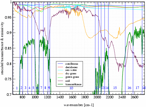
The Infrared Atmospheric Sounding Interferometer (IASI) range (645-2760 cm-1, 8461 channels) has been divided into 18 wavebands with respect to their usefulness for the channel selection (informative bands). The wavebands have been chosen more narrow and dense in areas with high (> 0.5) transmittance running average over 40 channels. This was done in order to follow the variability of the land cover types spectra and to validate the emissivity climatology created from MODIS emissivity maps (channels 31 and 32). The resulting wavebands are: 645-760, 760-805, 805-885, 885-950, 950-1000, 1000-1068, 1068-1135, 1135-1210, 1210-1240, 1240-1968, 1968- 2020, 2020-2064, 2064-2120, 2120-2180, 2180-2450, 2450-2575, 2575-2720, 2720-2760 cm -1. Climatological fields of surface spectral emissivity were created respectively to these wavebands. The creation was based on the global new land cover types and vegetation maps with resolution of 0.5 all over the globe (Masson, 2003) and SSE calculated for each of 14 simplified types from separate emissivity spectra of different natural and man-made materials. Then, the SSE maps were taken as an input for the modified climatological configuration of the ARPEGE model in which emissivity was interpolated to the final model grid.
Figure 1 : IASI transmittance and emissivity spectra of different land cover types. Transmittance (thick green) is a running average over 40 channels (scaled by 1/3 then shifted by +0.6).
The validation of the spectral emissivity climatological maps has been done in a few steps. Firstly we have compared (subjective) SSE maps for wavebands 805-885 cm-1 and 885-950 cm -1 with the MODIS emissivity maps for channels 32 and 31 respectively. The next step consisted in testing the new SSE in the radiative-transfer model RTTOV-7 with use of observations of HIRS instrument channel 8, which points to the surface. Finally, tests were performed with real AIRS data in pre-selected 324 channels (also using RTTOV-7).
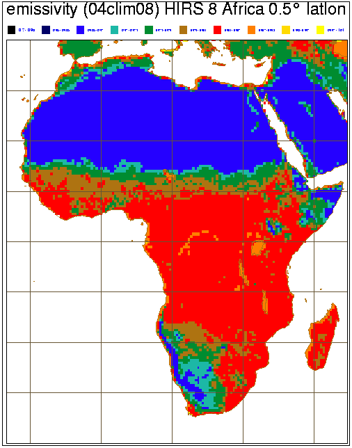
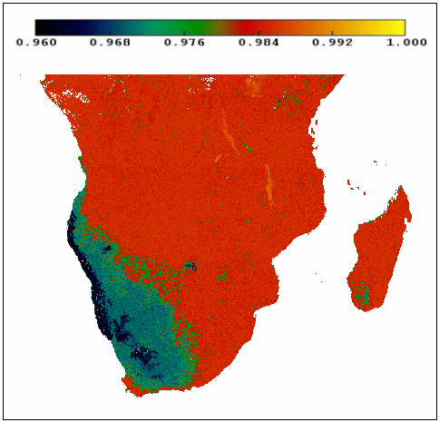
The Moderate Resolution Imaging Spectro-radiometer (MODIS) instrument on board NASA's Terra satellite routinely retrieves land surface products, and SSE among them. The method used for retrieval of emissivity maps which were used for our initial comparison was the "split-window" technique, using MODIS bands 31 (centred at 900 cm-1 ) and 32 (833 cm-1). These data are available at 1 km spatial resolution, and temporally divided into groups: individual swath data, 1-day average and 8-day average. Figure 2 presents an example of comparison of the surface spectral emissivity climatological map for the month of August against the MODIS SSE composite of individual swaths for the 20 of August 2000. One can note a good correspondence between the emissivity fields.
MODIS data are free of charge and can be accessed from the webpage referenced in bibliography.
|
|
|
Figure 2 : On the left side - climatological map of the SSE for the month of August, and on the right one the SSE composite map retrieved from MODIS band 31 measurements. Both figures have the same colour scale.
As already mentioned, this new SSE was also tested against observations of the HIRS instrument, for channel 8. This channel is centred at 900 cm-1 with half-power bandwidth equal to 35 cm -1. It corresponds very well to MODIS band 31, is very sensitive to surface parameters and it can be used to detect cloud contamination. As we work with surface data, so there is a strong requirement that the radiances we use were measured in clear-sky conditions. Tests have been done on the differences between measured and the forecasted brightness temperatures (obs-guess) in this channel window. As a forecasted brightness temperature (Tb) we use the brightness temperatures calculated in RTTOV-7 from atmospheric state vector taken from the 6-hour ARPEGE model forecast. This state vector is a vertical atmospheric profile containing the temperature and humidity at 43 pressure levels, surface air and skin temperature, surface pressure and surface spectral emissivity. A cloud test to eliminate the cloudy points we applied on channel 8, assuming that for clear-sky conditions the difference between measured and the forecasted Tb lies in between -1 and 2 K and is not latitude dependent .
a |
b |
c |
d |
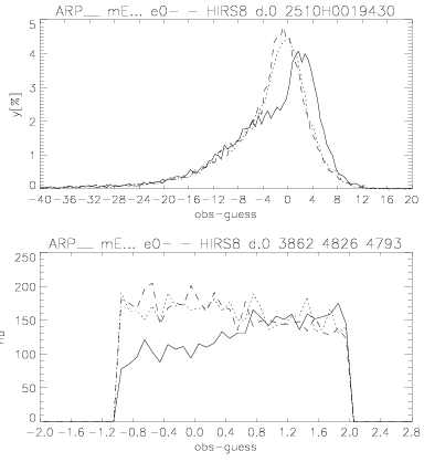
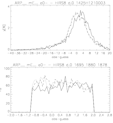
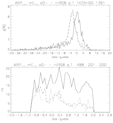
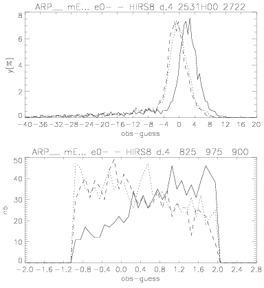
Figure 3 : Histograms of obs-guess values for different days and domains. a) and b) are cumulated over the whole globe, c) over Europe and d) over Africa. Temporal ranges are: a) 25-31.12.2002 cycle 00z, b) 14-25.06.3002 cycle 12z, c) as"b" but cycle 00z, d) as "a". Upper graphs : whole sample, lower ones : just "not cloudy" points considered. Solid lines : used ARPEGE emissivity, dotted lines : new SSE, dashed lines : RTTOV-7 emissivity.
To evaluate the quality and usefulness of the new climatology for emissivity, we compared the values of obs-guess with the RTTOV-7 run for different values of surface emissivity for the same state vector. As a first reference run the emissivity from ARPEGE was used, i.e. SSE=0.93 for dry land, 0.99 for moist land and partial snow-cover and 1.00 for ice-caps and full snow-cover.
The second one was RTTOV-7 run with its own emissivity value, i.e. SSE=0.98 everywhere over land. All the tests were performed on the same sample of initial profiles. On Fig. 3 the top graphs represent histograms of the full range of obs-guess values, and the bottom ones - the number of cloud free or small obs-guess points in each sample. The solid line is the ARPEGE reference, the dotted one corresponds to the new SSE, and the dashed one to the RTTOV reference. Note the values written in the titles of bottom graphs, they are the number of profiles for which obs-guess values pass the "cloud test".
The results are not obvious to interpret, they do not show clearly and unambiguously the general improvement of the estimated Tb converted by the radiative-transfer model with the use of the new surface emissivity. We compared the number of profiles for which the difference: observed Tb and estimated one in RTTOV, had stayed in the range -1 to 2 K ("cloud test"). What we can observe is that for the period 25.12.2002-10.01.2003 use of new SSE considerably improves the values of simulated brightness temperature in comparison with the ones obtained with the use of the SSE from the ARPEGE model (Fig. 3a). On the contrary for the period of 14-25.06.2003, especially in Europe, use of surface emissivity from global model gave the best results (Fig. 3c). One explanation of that could be the unusually hot and dry summer in that region this year. The state of vegetation was not similar to the "climatological" one. It means that instead of green grass and crops there were dry ones. As one can see on Fig. 1 the difference between dry and green grass emissivity spectra in band n° 4 (corresponding to HIRS channel 8) was significant. So, as the result SSE=0.93 (as it is in ARPEGE) appeared to be better for that unusual period than the new SSE with values between 0.973 and 0.987. Considering Tb calculated with use of SSE=0.98 (RTTOV default value for land) as a reference, it seems that the new SSE did not improve very much the estimation of brightness temperature. In some cases the difference in the number of "good" points was negligible (Fig. 3abc), in the others it could reach up to 8 percent (Fig. 3d).
In general one can say that the use of new SSE decreased the difference between measured and the simulated brightness temperatures, or stayed neutral. But there could exist exceptions while some extreme, long-term atmospherical conditions appeared. Moreover some additional tests on just clear sky profiles could give more detailed ideas about new SSE behaviour.
For the validation of the new SSE with usage of AIRS measurements, the same strategy was applied, with a different cloud detection and channel selection. The AIRS cloud detection scheme was based on multi-channel data, and it was found to be quite sensitive to small clouds only partially filling the field of view, optically thin cloud and stratiform cloud with a top temperature near identical to the surface (Smith, 2003). So, it was more accurate with comparison to the "cloud test" we have applied to HIRS 8 data. Additionally the AIRS imager was also used to detect clouds. As a result the validation of new surface emissivity have started on profiles for purely clear sky conditions.
As the Atmospheric Infrared Sounder is an instrument with very high spectral resolution the use of all 2378 channels is not practical and efficient. So thinning of the data was advised and the subset of 324 channels was prepared by the NOAA AIRS Science Team. These channels were grouped into the 18 earlier mentioned bands, but because of some differences in spectral coverage of IASI and AIRS instruments, the wavebands number 11, 12, 13, 14 and 18 were out of AIRS range. Additionally in ARPEGE 1D-Var satellite radiances assimilation there was no ozone analysis included, so channels from bands 5, 6, 7 and partially 9 were blacklisted from the assimilation process (i.e. they do not enter the analysis). The other problem was caused by "solar contamination" in the short-wavelength part of the spectrum. Channels touched by this problem could be used by night, but then the AIRS imager could not be used to detect clouds. As a consequence we rejected also the wavebands 16, 17 and partially 15. From the remaining bands we also excluded the ones with low transmittance values (these channels were not seeing the surface), namely number 1, 10 and also 2. Finally only two full bands remained : 3 (four channels) and 4 (four channels), and partially band 9 (one channel) and 15 in long-wave part. Considering the usefulness of the bands we neglected band 9 because of a lack of channels to compare with and to analyse impact of the SSE. From waveband 15 we kept four long-wave channels pointing to the levels closest to the surface. Summarizing, for SSE validation with the AIRS data and subsequently in 1D-Var we could use three bands 3, 4 and 15, with 12 channels.
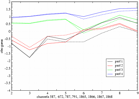
Figure 4 : Obs-guess values of Tb for 8 selected channels in 2 bands. Continuous line refers to SSE=0.98 (RTTOV, reference), the same colour but dashed line corresponds to new SSE.
As we intend to use the same wavebands for 1D-Var, the new B matrix has been calculated just for these bands, and very high correlation was found between adjacent bands 3 and 4, and almost zero correlation of these two bands with band number 15. For simplicity reason (diagonal B) we merged wavebands number 3 and 4 as the average emissivity values in those were relatively close. And the result was, that finally we would use 8 channels: four from merged bands 3 and 4, and four from band 15.
First validation tests were performed for 4 randomly chosen profiles over land. As can be seen on Fig. 4, introducing the new SSE values for separated channels in wavebands improved the estimation of the brightness temperature from the atmosphere state-vector especially for band 15. The integer values of x axis from 2 to 9 correspond respectively to AIRS channels : 587, 672, 787, 791 (merged bands 3 and 4) and 1865, 1866, 1867, 1868 (band 15). Further tests will be performed on a larger sample of profiles.
A scheme of "one-dimensional variational analysis" (1D-Var) is a method for extracting information from satellite-measured radiances for use in the data assimilation system. It is based on the same principles as 3D-Var, just applied to the analysis of atmospheric profile in single location, using a forecast profile and its error covariance as a constraint. Brightness temperatures corresponding to the state vector x are computed using radiative-transfer model RTTOV-7. The used background covariance matrices B for temperature, humidity and emissivity are those shortly described above, and in details in Szczech-Gajewska (2002).
Work on nonlinear 1D-Var has started, but still there no results to present. Up to that moment the introduction of emissivity as a control variable have been applied, but not yet tested.
In conclusion, new emissivity maps based on ECOCLIMAP are consistent with MODIS SSE maps retrieved with the "split-window" method for bands 31 and 32. Usage of the local surface spectral emissivity (at the closest point to the position of profile) in radiative-transfer model RTTOV-7 with HIRS 8 data have not clearly shown that the estimation of the brightness temperature from atmospheric profiles was really improved with comparison to default SSE value for RTTOV-7, but it was usually better than with the emissivity currently used in ARPEGE. In the case of Tb simulated with ARPEGE SSE as reference, the increase of the number of "good" points while using the new surface emissivity reaches up to 25 % globally (with some exceptions). Preliminary results for AIRS data showed that we could expect Tb values simulated in RTTOV with new SEE closer to the measured ones. But the validation on more numerous samples of profiles is still required. Finally the work on 1D-Var must be continued on the inversion of radiances and emissivity retrieval. Tests with background error covariances matrices, especially one for T, with explicit correlations between Ts and atmospherical T, should be performed.
V. Masson, 2003 : A Global Database of Land Surface Parameters at 1-km Resolution in Meteorological and Climate Models, accepted to Journal of Climate, 16.
J. Smith, A. McNally, P. Watts, 2003 : Performance of a high spectral resolution cloud detection scheme for AIRS data used at ECMWF, P roceedings of Symposium on Earth Observation and Satellite Meteorology .
R. Snyder, 1998 : Classification-based Emissivity for Land Surface Temperature Measurement from Space, Int. J. Remote Sensing, 19, n°.14, 2753-2774.
M. Szczech-Gajewska, 2002 : Parameterisation of background error statistics for surface parameters (LST, SSE), to be used for future assimilation of advanced IR sounders over land, ALATNET Newsletter, 5.
Laboratory emissivity data were taken (autumn 2001) from : http://speclib.jpl.nasa.gov/ , http://asterweb.jpl.nasa.gov/ , http://www.icess.ucsb.edu/modis/EMIS/html/em.html
MODIS hdf files were ordered from : http://edcimswww.cr.usgs.gov/pub/imswelcome/