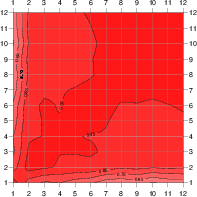
scale
correlations for T over LAND

correlations for T over SEA
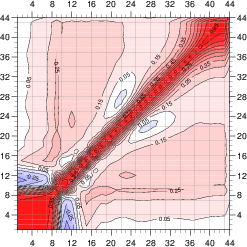
global correlations for T
I. Introduction
To retrieve and assimilate the very fine spectral resolution measurements from advanced IR sounders (IASI/AIRS) we need to have the ancillary information (background) which specifies the behaviour of the variables or constitutes some a-priori constraints. In order to estimate the quality of the background information one need to compute the background error covariance, called B matrix. This matrix is one of the most important elements of the data assimilation system - it determines the filtering and the propagation of the observed information.
A first estimate of land surface skin temperature (LST) can be taken from model forecast, and surface spectral emissivity (SSE) can be provided by climatological values depending on the land cover type. To calculate the background error covariance for temperature (vertical profile + surface) the Ensemble method was used. This method is based on an ensemble of independent analysis experiments (members), in which all observations are perturbed. The perturbations cause the differences between members analysis, and next they propagate to the 6 h forecast and consequently to the next analysis cycle, in the form of uncertainties in the background. The statistics of the differences between background fields for pairs of ensemble members represent the background errors. Our ensemble is composed of 10 perturbed forecasts for 30 days period (Belo Pereira, 2002), and the calculations of B matrix were done in gridpoint space (separately for land, sea and all points together) for the 43 IASI radiative transfer model (RT-IASI) levels. For the emissivity the B matrix is calculated for 12 wavebands, separately for each of the different land cover types. Chosen wavebands fully cover the IASI and AIRS spectral range. The data for emissivity climatological maps (SSE background) were taken from the MODIS spectral library.
II. Background error statistics for the temperature
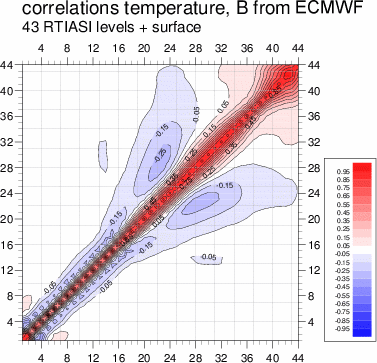
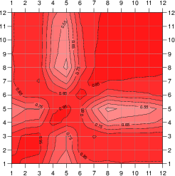
As a background (first guess) for temperature we use the 6h forecast from the ARPEGE (cy22t1) model, and to estimate the background errors with Ensemble method we made gridpoint calculations. It means that the ensemble of forecasts was projected onto ARPEGE gridpoint space (truncation T199) and interpolated onto 43 RT-IASI levels. The final ensemble is composed of 10 independent 3d-var analysis experiments for the month of May 2001. For consecutively numbered members were calculated the differences between the background fields for each 6h cycle from 5th to 30th of May 2001, so the statistics were based on 234 background differences. From them we calculated the background error covariances, separately averaged over gridpoints of land, sea and globally. The vertical correlations between all levels derived from the obtained matrices are shown on the Figure 1. The surface is the 44th level.
scale |
correlations for T over LAND |
correlations for T over SEA |
global correlations for T |
Fig.1. Correlations for T for 43 RT-IASI levels + surface skin temperature, for different areas (based on ARPEGE grid).
The correlations for high atmosphere levels do not look realistic, the reason for that is the extrapolation from 31 ARPEGE levels to 43 in the radiative transfer (RT) model. In the stratosphere RT has 14 levels and ARPEGE only 3, next 15 RT levels (stratosphere and upper troposphere) correspond to 12 in the forecast model. Just for the lower troposphere (below 500 hPa) an equivalent spanning of levels between ARPEGE and RT-IASI is satisfactory : 16 model levels refer to 14 of RT.
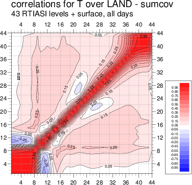
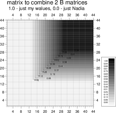
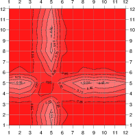
The global B matrix generally used in RT-IASI was calculated at ECMWF (J.-N. Thépaut), also using the Ensemble method, but the interpolation to 43 RT-IASI levels was from 60 levels in the IFS model, which allow a better description of the high atmosphere. Because none of the B matrices is experimental and we wanted to keep the land surface characteristics and remove "noise" from the top of the atmosphere, we decided to mix both matrices - the present one for land and the ECMWF one. A "transition matrix" combining them was used. For the first 14 RT levels it keeps just the ECMWF covariance, above the 29th level just mine, and in-between a mixture of both matrices, with a linearly growing ratio (with a step of 6.25%). The original matrices, the transition matrix and the final one are shown on Figure 2.
|
|
|
|
|
Fig.2. Creation of the final B matrix for land. The ECMWF B matrix is actually the matrix calculated by J-N Thépaut.
Created in such a way, the matrix is non singular, and 1d-var tests with this matrix have given positive results.
Also to give idea about the values of calculated covariance, Figure 3 presents vertical profiles of standard deviations (STD, square-root of B diagonal) for temperature.
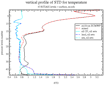
Fig.3. Vertical profiles of STD for temperature. 43 RT-IASI levels + surface.
In blue are gridpoint calculated values : dark blue corresponds to the values
for the land and dashed light blue to the sea ones. Black curve is the ECMWF
temperature standard profile and in dashed red is the profile derived from
"combined" matrix.
III. Background error statistics for spectral emissivity
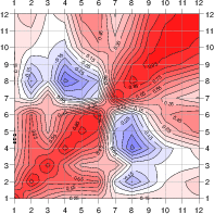
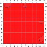
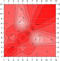
The creation of the background for the emissivity, the climatology, was described in my previous ALATNET report. The method hasn't changed, just we have chosen new wavebands, not equal ones, but corresponding to the IASI transmittance function. Also additional tests had shown that we will use the variable -log(1-SSE) instead of SSE. Emissivity data (laboratory measurements) for many types of soil, vegetation and ice were taken from the MODIS spectral library. We obtained from there : 5 sea-water samples, 9 samples of ice and snow, 128 samples of different kinds of soils, 24 samples of high vegetation (trees) and 5 samples of low vegetation. "Sample" means the infrared emissivity spectrum of some plant or material (range: 600-3000 cm-1). Unfortunately samples do not have the same spectral resolution, so instead of interpolating all spectra to the same resolution and then calculating statistics, we decided to estimate first the mean emissivity value per waveband and per sample, and average them for each land cover type. Next, in each waveband we calculated the differences for each land type, and afterwards emissivity covariances for all 12 bands. Calculation of statistics were done for -log(1-SSE). On the figures below are correlations for separated land cover types (Fig. 4), and global ones (Fig. 5) created with and without respect to the percentage of each land type at the global scale.
HIGH VEGETATION |
LOW VEGETATION |
BARE SOIL |
ICE / SNOW |
Fig.4. Correlations of SSE for 12 spectral wavebands, separate for each land cover type.
scale |
|
|
Fig.5. Global correlations derived from covariances averaged over all land cover types.
SSE of high vegetation and ice show very strong correlations between all wavebands. It is caused by the low variability of their spectra with wavenumber. The exactly opposite case is for bare soil emissivity and partially for low vegetation. For bare soil, surface spectral emissivity can change from 0.77 to 1.0 in IR IASI range (645-2760 cm-1 ); for low vegetation it can change from 0.88 to 0.98. The weights (percentage of the globe covered by each surface type) were taken from the ARPEGE grid : sea water - 53.4%, ice/snow - 1.4%, high vegetation - 13.5%, low vegetation - 29.2% and bare soil - 2.5%.
IV. Summary
The already prepared background allows us to start work with 1d-var retrieval and assimilation. The first step will be the insertion of SSE as a control variable. Afterwards the experiments with inversions in 1d-var will address direct sensitivity - influence of SSE change on radiance, calculation of the gradients with respect to SSE and LST. Additionally the work on emissivity needs more investigations. The reason is that in reality the emissivity mixing is not linear, it depends on LST. Nevertheless, for the time being we will test all B matrices for emissivity, to take the decision which one to use. For the temperature, "combined" B matrix already is in use.
References
M. Belo Pereira : "Improving the assimilation of water in a NWP model", ALATNET Newsletter 4, 2002
Laboratory emissivity data were taken (autumn 2001) from :
http://speclib.jpl.nasa.gov/, http://www.icess.ucsb.edu/modis/EMIS/html/em.html