Diagnostic tools applied to ALADIN forecasts in situations of deep convection over Portugal
Margarida Belo Pereira (Margarida.belo++at++meteo.pt )
Portuguese Meteorological Institute
The ALADIN model, with 31 vertical levels and the CYCORA_bis package, is running operationally at the Portuguese Meteorological Institute. The lateral boundary conditions are updated every six hours from ARPEGE forecasts. Recently two cases of deep convection and one false alarm have been studied, in order to find out the capability of the ALADIN model in forecasting the onset and evolution of convective events. Moreover, it would be interesting to know if derived fields from the model could offer a useful additional information for operational forecasters. In order to accomplish this aim, some diagnostic tools were developed and applied to ALADIN forecasts.
In these paper I only present one example of deep convection over Portugal, on day 25/06/2002.
2.1. Diagnostic tools
To identify the areas where favourable conditions exist for the development of deep convection, the following diagnostic parameters are used : (in)stability indices, low-level moisture convergence and temperature advection.
In order to evaluate the stability, the following stability indices were computed : Energy index, Convective instability index, Total-Totals, Modified Total-Totals, Jefferson index, Modified K index and Severe Weather Threat (SWEAT) index. In three cases the SWEAT index was the most useful one, therefore I only present the description of this index:
SWEAT index = 12 Td850 + 20 (TT - 49) + 2 f850 + f 500 + 125 (S + 0.2)
where :
- Td850 is the dew-point temperature in Celsius at 850 hPa (this term is set to zero if negative);
- TT is the Total-Totals index, which is the sum of 850 hPa temperature and dew-point temperature less twice the 500 hPa temperature (T 850 + Td850 - 2 T 500).
- f850 and f500 are the wind speed, in knots, at 850 hPa and 500 hPa respectively.
- S = sin (500 hPa wind direction - 850 hPa wind direction) ; this term is set to zero if any of the following conditions is NOT fulfilled :
In order to evaluate the low-level moisture convergence, the integral of the convergence of specific humidity (Fq ) is computed in the layer between 1000 hPa and 850 hPa:
2.2. Deep convection associated with a cut-off low
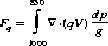
On 25 June 2002, the weather over Portugal is affected by a cut-off low situated at south-west of the Iberian Peninsula. The onset of deep convection occurs between 15 h UTC and 15:30 h UTC in the centre region of Portugal, near Ansião (see figure 1a and table 1).
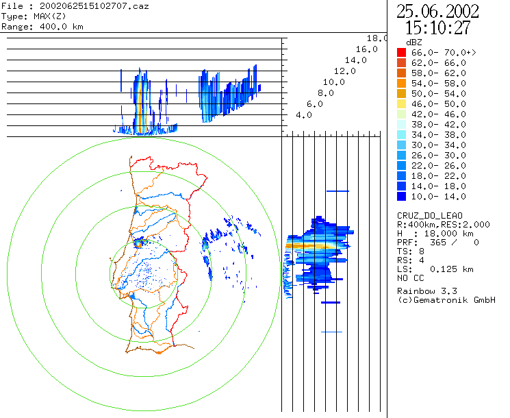
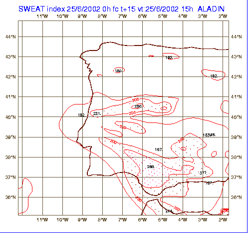
At 15 h UTC, the SWEAT index forecasted by ALADIN indicates a local maximum (221) close to Ansião (see figure 2b and table 1), where convection takes place. Its intensity increases during the afternoon, reaching a maximum value of 270 at 18 h UTC. In this area and a little further to East, between 13 h and 18 h UTC, the ALADIN forecast shows an area of low-level moisture convergence, which reaches its maximum intensity (31.10-1 g.m-2.s-1 ) at 15 h UTC (see figure 3). The presence of low-level moisture convergence in this area seems to be an important factor for the onset and development of deep convection east of the area where convection started first (see figure 1). Moreover ALADIN forecasts a warm advection at 850 hPa in the area where deep convection takes place (figure not shown).
Energy, Jefferson and Modified K indices also give a very good agreement between the area where the onset of convection occurs and the area of maximum instability forecasted by ALADIN. However, in terms of time-evolution, the SWEAT index has a better performance.
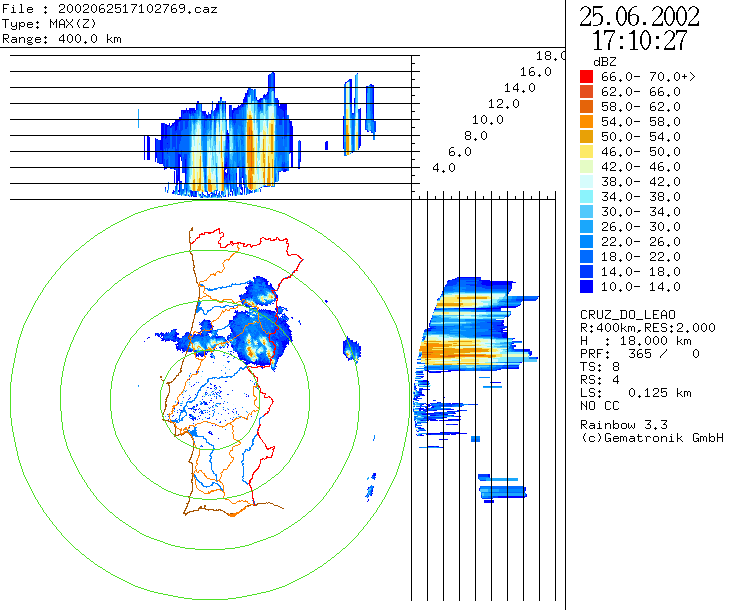
In the area around Lisbon, ALADIN forecasts instability (with values of SWEAT changing from 150 to 300, between 12 h and 18 h UTC) and convective precipitation (figure 2). Nevertheless, the ALADIN forecast indicates divergence of moisture (figure 3), which explains why deep convection doesn't take place in this area.
So, using the condition of low-level moisture convergence as a necessary condition for the development of deep convection, a forecaster would be able to detect the false alarm of precipitation forecasted by ALADIN (figure 2a) in the area around Lisbon.
|
Station |
Lat (N); Lon (W) |
16 h |
17 h |
18 h |
19 h |
|
Ansião |
39.91° ; 8.33° |
1.0 |
7.0 |
0.0 |
0.0 |
|
F. C. Rodrigo |
40.87° ; 6.90° |
0.0 |
2.0 |
3.0 |
0.0 |
|
Zebreira |
39.52° ; 7.10° |
0.0 |
4.0 |
5.0 |
0.0 |
|
P. Douradas |
40.42° ; 7.63° |
0.0 |
0.0 |
3.0 |
0.3 |
|
Covilhã |
40.17° ; 7.32° |
0.0 |
0.0 |
5.0 |
0.0 |
|
Lousã/Aero |
40.13° ; 8.23° |
0.0 |
0.0 |
0.9 |
4.0 |
|
Nelas |
40.52° ; 7.85° |
0.0 |
0.0 |
0.0 |
0.2 |
|
Anadia |
40.43° ; 8.43° |
0.0 |
0.0 |
0.0 |
5.0 |
Table 1. Hourly observed precipitation (between 16 h and 19 h UTC).
 |
(a) |
| | |
 |
(b) |
| Figure 1 : Radar reflectivities at 15:10 h UTC (a) and at 17:10 h UTC (b). | |
| | |
 |
(a) |
| | |
 |
(b) |
| Figure 2 : Accumulated precipitations in 6 hours (a), and SWEAT index (H+15) (b), from the ALADIN forecast. | |
| | |
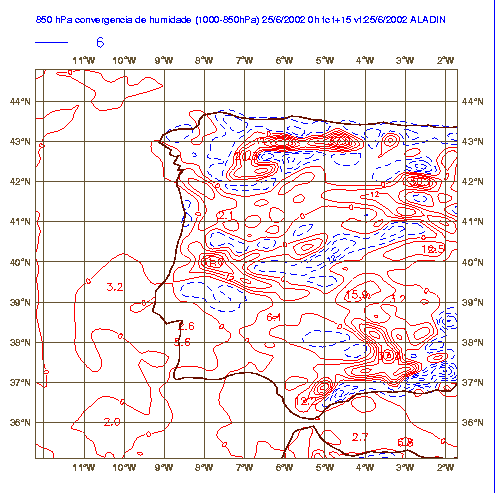 | |
| Figure 3 : Divergence (dashed blue lines) and convergence
(solid red lines) of water-vapour flux in the layer 1000-850 hPa, forecasted
by ALADIN for 15 h UTC on 25 June 2002. The isopleth interval is 6.10 -1 g.m-2.s-1 . | |
In two of the recent case studies, the ALADIN forecast was useful for the thunderstorms forecast. Moreover, the results show that deep convection occurs in the areas where ALADIN forecast shows both instability and low-level moisture convergence. However, in one of the cases studied, ALADIN forecasts too much instability and produces a false alarm (FA) of convective precipitation. The comparison of diagnostic parameters derived from ALADIN analysis and forecast seems to be an important factor to detect the FA.