3. Margarida BELO PEREIRA : "Improving the assimilation of water in a NWP model"
Introduction
The background (6h forecast, also known as first guess) error covariance matrix (known as the B matrix) is one of the most important elements of a data assimilation system, as it determines the filtering and the propagation of the observed information (Daley, 1991). Presently, the B matrix of ARPEGE is determined using the NMC method, which is very easy to implement. This method uses differences between 48 h and 24 h forecasts (fc48-fc24), which start at different times. So, it relies on the differences between the evolution of the 24 h forecast which starts from one analysis (r0) and another one which starts from a 24 h forecast. The analysis r0 is build with the analysis increments from the successive analyses in the assimilation system over the 24 h period between the initial times of the two forecasts. Hence, the forecast differences (fc48-fc24) will appear mostly in data-rich areas, because the analyses will not correct the forecasts in data-sparse areas. This represents a drawback from this method since the largest errors in analyses are likely to be in data sparse areas. A second disadvantage of this method is that it assumes that the structure of the statistics of the forecast error over 24 hours is not dependent on the range of the forecast. However, this assumption is likely to be not true. For these reasons, another method called Analysis Ensemble Method was tried at Environment Canada (Houtekamer et al., 1996) and at ECMWF (Fisher, 1999). In the present work, this new method was "implemented" in the cycle 22T1 of ARPEGE.
Ensemble Method
The idea of this method is to run an ensemble of independent analysis experiments. For each experiment all observations are perturbed adding an independent random number, which has a Gaussian distribution with mean zero and variance equal to the prescribed variance of observation error. The effect of such perturbations is to generate differences in the analysis for each experiment. These differences are a measure of the uncertainties on the analyses, which are propagated to the 6 h forecast and consequently to the next analysis cycle, in the form of uncertainties in the background. After a few days of assimilation, the statistics of the differences between background fields for pairs of members of the ensemble equilibrate and it is assumed that the differences between independent members (experiments) of the ensemble represent the background errors, from which the statistics related to the B matrix can be estimated.
The ensemble consists of 10 31-level 3d-var analysis experiments for the period of 1-30 May 2001. Initial conditions for all experiments were provided by an analysis for 18z of 30 April from a 3d-var unperturbed experiment.
The analysis experiments (members) were arbitrarily numbered from 31 to 40. The differences between the background fields for consecutively-numbered experiments were calculated for each 12z cycle between 4/5/2001 and 30/5/2001. This provided 9x27=243 differences between background fields, from which we estimate the statistics of the background error.
Results : visualization of forecast differences
The differences between the 6 h forecasts were analysed individually during the first days. On the first day of assimilation, the differences were located mainly over the extra-tropics for temperature, and over Land and near the coast for specific humidity, but these differences were spread (as expected) over the whole globe on the second day.
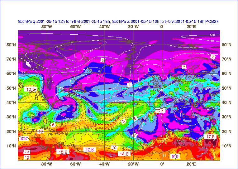
Moreover, the method seems to produce some error structures which seems to be related with the synoptic situations. As an illustration, differences between member 36 and 37 are shown for day 15, for some fields.
It is worthwhile to note that the largest differences (-4.7 hPa) in Geopotential at 850 hPa are located in the area of the low situated in North Atlantic (NA), near Canada (see figures 1 and 2). Moreover, the differences are also negative in the other depression over NA. This means that for member 37, the two lows are deeper than for member 36. This is an interesting example of the possible link between structures in the background field and structures in the background errors. Moreover, the largest differences in specific humidity (-8.9 and 6.8 g/kg) and in temperature (-5.7 °C) occur in Equatorial Africa on the area of strong gradients associated with the Inter-Tropical Convergence Zone (ITCZ) (see figures 1, 3 and 4).
Figure 1 - Geopotential (isolines of 5 hPa) and specific humidity (isolines of 1 g/kg) at 850 hPa for member 37.
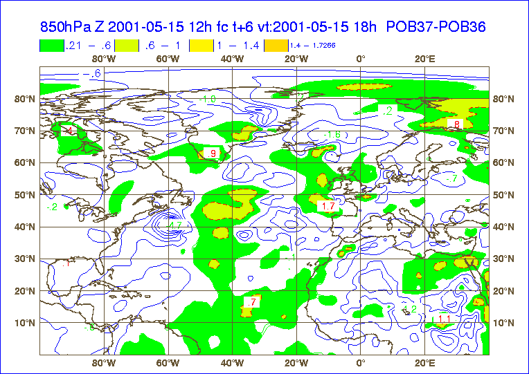
Figure 2 - Differences in geopotential (isolines of 0.4 hPa) at 850 hPa between member 37 and member 36. The areas where the differences are larger than 0.2 hPa are coloured.
The second area of largest uncertainties on q field occurs in the frontal system located in the western part of NA. For member 37, the gradient in q through the cold front is enhanced, due to positive anomalies (in this text the term anomalies refers to the differences between POB37 and POB36) in the moist sector and to negative anomalies in the dryer part behind the cold front (figures 1 and 3). For temperature, it is worthwhile to mention the positive anomalies in warm sector of the frontal system in NA and the negative anomalies in the cold and cool sectors (see figure 4). As a consequence of these uncertainties there is an intensification of the frontal system in one member (POB37) relatively to the other.
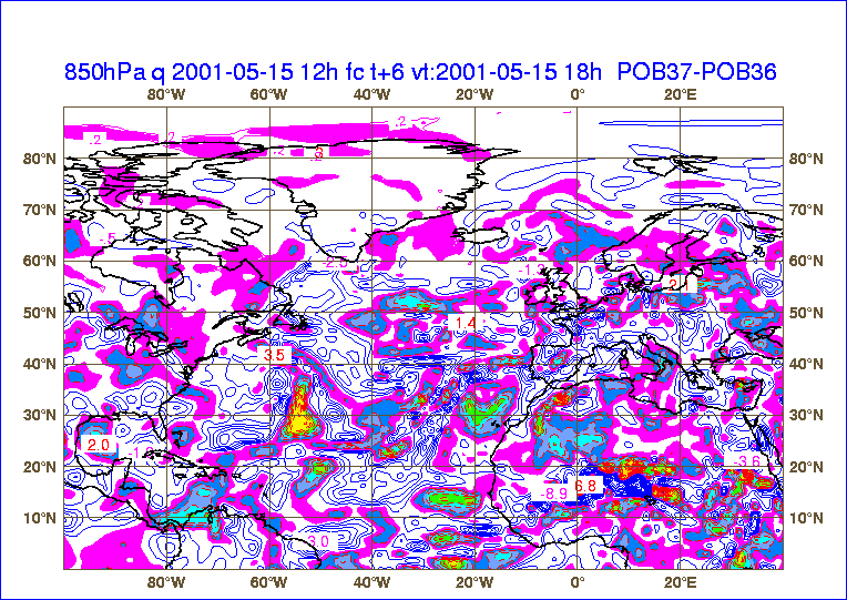
Figure 3 - Differences in specific humidity (isolines of 0.4 g/kg) at 850 hPa between member 37 and member 36. The areas where the differences are larger than 0.2 g/kg are coloured. The maximum positive anomalies are represented in red and burgundy and the minimum are in violet.
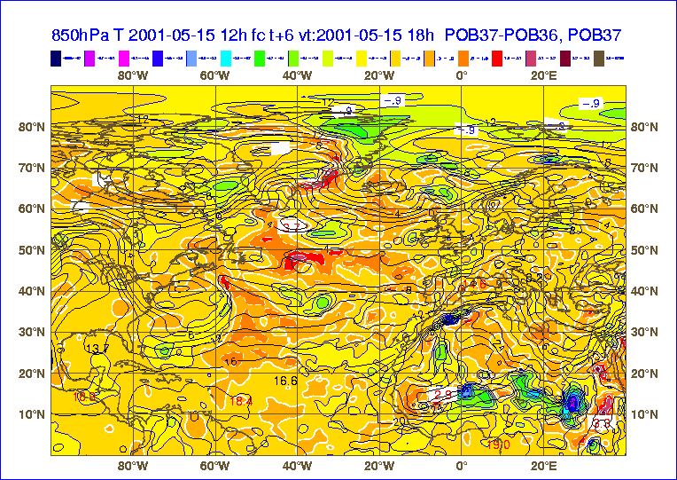
Figure 4 - Temperature (isolines of 2 °C) at 850 hPa for member 37. Differences in temperature (isolines of 0.6 °C) at 850 hPa between member 37 and member 36. The isoline of 0.3 °C is plotted in white. The differences larger than 0.3 °C are plotted in colours from orange to red. The differences smaller than 0.3 °C are plotted in colours from yellow to blues and violets.
Results : preliminary examination of some statistics
The vertical profile of total standard deviations for the first 6 days and for the average over the period 4/5/2001 to 30/5/2001 is plotted in figure 5 for specific humidity and for unbalanced divergence. For both variables it is possible to verify that the global statistics stabilize on the 4th day. The same result is achieved for temperature and vorticity (not shown). This is the reason why the first 3 days are not taken into account to compute the statistics of forecast errors. For both q and divergence the maximum standard deviation occurs in the Planetary Boundary Layer (PBL). Moreover, for q the standard deviation decreases drastically for levels above 700 hPa (level 20).
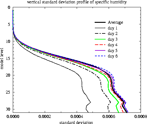
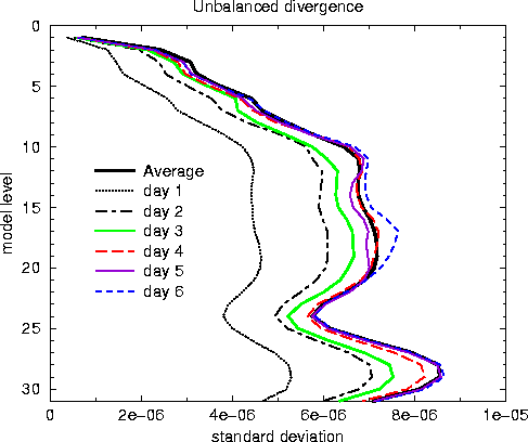
Figure 5 - Vertical profile of standard deviation for specific humidity and unbalanced divergence.
The auto-correlation spectra for unbalanced divergence is presented in figure 6 (left). Most of the variance of its error near tropopause and at stratospheric levels comes from synoptic scales, for wavenumbers between 20 and 40 (wavenumber 1 corresponds to the earth circumference, 40 000 km). For middle and low troposphere the spectra are much broader, which means that contributions from mesoscale phenomena are also important. The shape of auto-correlation spectra for vorticity (not shown) is very similar. However, at middle troposphere and at stratospheric levels, vorticity errors have a larger contribution from larger scales than divergence errors.
The auto-correlation spectra for specific humidity (not shown) shows very little variation with vertical levels. Moreover, its maximum occurs for wavenumbers between 15 and 25 and its shape is sharper than for divergence, which means that the contribution from mesoscale to the variance of q error is smaller than for divergence. In PBL, the maximum variance of temperature error comes from wavenumbers between 10 and 30. For levels above PBL, the auto-correlation spectra of temperature is much sharper, having its largest energy in planetary and synoptic scales (wavenumbers less than 10).
The global vertical correlation for unbalanced divergence is presented in figure 6 (right). It shows that bottom levels are negatively correlated with the levels from middle troposphere. Moreover, the middle tropospheric levels are negatively correlated with the PBL and with the upper troposphere. For temperature, the most important feature is the anti-correlation between tropospheric and stratospheric levels (not shown).
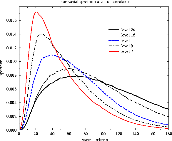
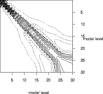
Figure 6 - Auto-correlation spectra for unbalanced divergence and for model levels 24 (near 850 hPa), 16 (near 500 hPa), 11 (near 300 hPa), 9 (near 215 hPa) and 7 (near 140 hPa). Average vertical correlation (on right hand side). Positive values (larger than 0.1) are plotted in solid lines. Negative values (smaller than -0.1) are plotted in dashed lines. The isoline spacing is 0.15.
Perspectives
In the near future we plan to compare the analysis error covariances and forecast error covariances. Moreover, we intend to compare the Analysis Ensemble Method and the NMC method.
References
Daley, R., 1991: Atmospheric Data Analysis. Cambridge University Press, 457 pp.
Fisher, M., 1999: Background Error Statistics derived from an Ensemble of Analyses. ECMWF Research Department Technical Memorandum No 79, September 1999, 12 pp.
Houtekamer et al., 1996: A System Simulation Approach to Ensemble Prediction. Mon. Wea. Rev., 124, 1225-1242.
| The previous ALATNET PhD and Post-Doc Studies |  |
Home | The next ALATNET PhD and Post-Doc Studies |