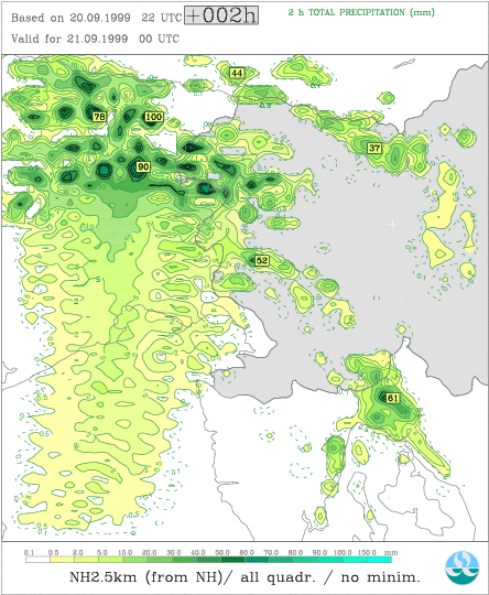
Figure1 (NH with "normal" orography) and Figure 2 (NH with "optimised" orography), both coupled from NH-5km
The second part of the first year in Ljubljana was mainly used for finding proper use of orography on high resolution to enable forecast fields, which can be used for evaluation. The crucial field is the vertical velocity field, which logically has big impact on the shape of the precipitation patterns.
Down to 5 km resolution no negative influence on the forecasted precipitation fields caused by orography can be found, neither in hydrostatic (H) nor in non-hydrostatic (NH) model runs. Further increasing of the resolution can cause unrealistic wavy precipitation patterns over the sea (see figure 1). This is true for both, H and NH runs as well.
The case which was chosen to try to investigate this problem is the 20.9.1999, which is part of one MAP-I(ntensive) O(bservation) P(eriod). The forecasting domain includes part of north-east Italy, western Slovenia and parts of north-west Croatia. Domain size is 79*79 points (without E-zone) and the main synoptic feature is a front which approaches from the west, had its main activity in northern Italy and was already weaker, when affecting the target domain. A semi-Lagrangian time-scheme was used and the length of the time-step was 30 seconds, while the horizontal resolution was approximately 2.5 km.
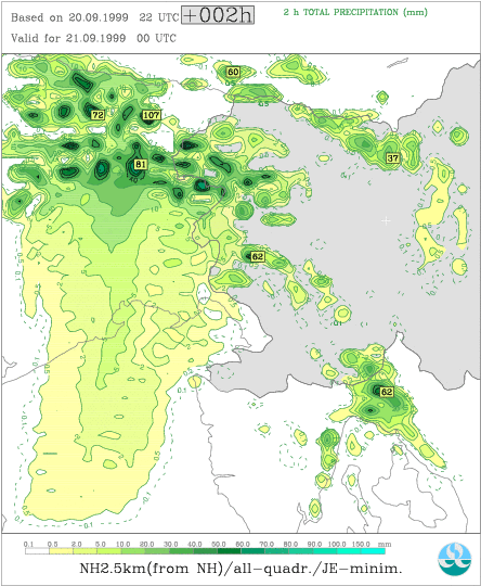
This front caused quite some precipitation in the western part of Slovenia, which was also forecasted by the model although the forecasted peaks are too high. Nevertheless the most important point remains the influence of the used orography on the smoothness of the forecasted precipitation fields, after it turned out that changes in the settings of the physics (like horizontal diffusion coefficients) or the geometry (larger domain) did not cure the problem. If the minimisation algorithm is used (e.g. Jerczynski's cost-function), while producing the "clim" files the negative impact can be reduced for the NH-run, but only if coupling is done from a non-hydrostatic run (see figure 2 - coupled from NH-5 km). In comparison to this, figure 3 shows the precipitation field if the NH model is coupled from H-5 km model (orography also with minimisation). For the hydrostatic run on 2.5 km however, the better (with minimisation) orography reduces the negative influence more significantly.
To get completely rid of this waves over the sea I also tried to use orography on coarser resolution than the other spectral fields. This means that the used orography, which is included in the "clim" files was produced on quadratic grid, while the other spectral fields were on linear grid, which in fact means an increase of the resolution by a factor of 1.5 . Thanks to Dominique and Ryad for giving support, how to correctly include this "new" orography. The results show that the use of the smoother orography (but still using the minimisation algorithm) gives the most realistic precipitation fields, which means, that additionally to the reduction of the "ocean" waves, also the mountainous northern part of the domain does not have that extreme differences of the amounts within short distance (see figure 4).
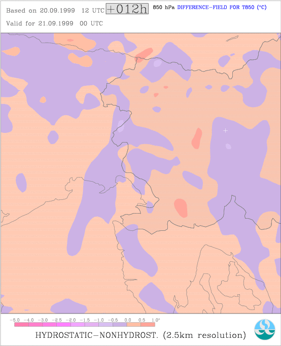
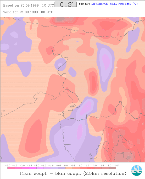
Another "problem" that appears when trying to evaluate the model (and especially the advantages of the non-hydrostatic version) is the fact that the differences between NH and H dynamics might be small when compared to differences that come from other sources, such as the resolution of the coupling model. Figures 5 and 6 should serve as an example to underline this fact. In figure 5 the difference field between NH and H fields for the 850 hPa temperature forecast is plotted, while in figure 6 the same is done for the difference between NH model coupled from 5 km and 11 km, respectively. It can easily be recognised, that NH and H forecasts are more similar than the NH forecasts from different coupling fields. The reason for the differences concerning the different coupling resolution might partly be caused by some kind of shift. So it won't be that easy to work out the advantages of the NH dynamics in an objective way, because besides the above mentioned problem additionally we have to deal with the fact that the density of observations is not high enough, if the resolution is already down to 2.5 km or lower (MAP database therefore has to play an important role).
The next steps will be to find the most proper coupling strategy (concerning the 'jumps' in resolution) and to investigate the model performance on several cases (in different synoptic situations), which were already chosen out of MAP.
See also : "Non-hydrostatic vs hydrostatic on high resolution", by Klaus Stadlbacher in the proceedings of the 10th ALADIN workshop.
Figure1 (NH with "normal" orography) and Figure 2 (NH with "optimised" orography), both coupled from NH-5km
Figure3 (NH with "optimised" orography) and Figure 4 (NH with smoother+"optimised" orography), both coupled from NH-5km
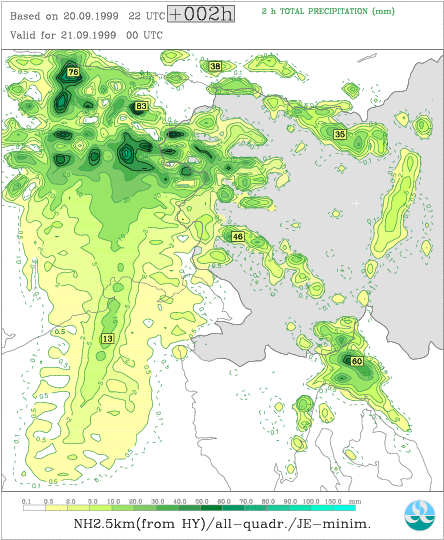
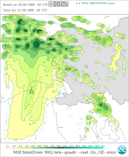
Figure 5 (differ. between NH and H runs) and Figure 6 (differ. between 11 km and 5 km coupling)
 |
Home |