B. Ahrens, IMG, University of Vienna, E-mail: Bodo.Ahrens++at++univie.ac.at
Y. Wang, ZAMG, Vienna, E-mail: wang++at++zamg.ac.at
K. Jasper, IKF, ETH Zürich, E-mail: jasper++at++geo.umnw.ethz.ch
1. Introduction
Hydrological models need meteorological input. The most important meteorological input is precipitation. In this short report we compare ALADIN (9.6 and 4 km gridspacing) quantitative precipitation forecast fields with observations and discuss the impact of differences in precipitation on runoff simulated with the hydrological model WaSiM-ETH (e.g., Jasper et al., 2000).
Target area of the reported investigations is the "Ticino-Verzasca-Maggia" (TVM) watershed (total area: 2627 km^2) upstream of Lago Maggiore. This area is well investigated and observed within the Mesoscale Alpine Programme (MAP) and the EU project RAPHAEL (Bacchi&Ranzi, 2000). Within RAPHAEL the hydrological model WaSiM-ETH has utilized meteorological input simulated with different models (e.g., MESO-NH, MC2, BOLAM) with encouraging results in runoff prediction. Here, we focus on a single RAPHAEL flood event in 1997 (27-30 June).
In the long run our goal is to improve coupling of meteorological and hydrological models. Fine scale (gridspacing ~1 km in Alpine catchments) precipitation forecast fields are necessary, for example, in flash flood prediction because of non-linear runoff response to precipitation. Gridscales of high-resolution operational NWP models are about 10 km. Therefore, spatial resolution of meteorological forecasts has to be improved (with dynamical and/or statistical downscaling) and this fine-scale forecast system has to be validated.
2. Meteorological simulations
We performed simulations with different configurations of ALADIN (cycle 11.2). The first configuration (called here ALADIN 9.6 km) is the hydrostatic ALADIN/VIENNA, actually operational at ZAMG, with 9.6 km gridspacing. ALADIN/VIENNA utilizes the "classic method" (following Gerard, 1999, Chap. VI) of moisture convergence modulation in the deep convection scheme with parameter setup LSRCON=FALSE and GCOMOD=1. The second configuration (ALADIN 4km(V1)) is non-hydrostatic (cf., Bubnova et al., 1995) with 4 km gridspacing. Moisture convergence modulation is done with the more physical and less tunable "smarter method" with parameter setup LSRCON=TRUE and GCOMOD=0. The third configuration (ALADIN 4km(V2)) is identical with ALADIN 4km(V1), but utilizes the "classic method" for moisture convergence modulation. Fig. 1 illustrates the configuration domains.
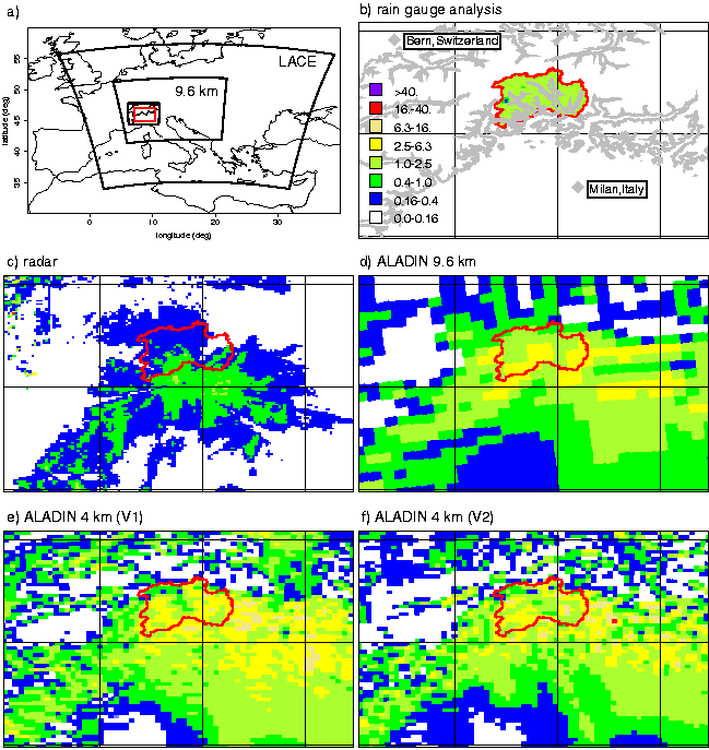
Figure 1: a) ALADIN (LACE, 9.6 km, 4 km) domains (black) and analysis sub-domain (red); b) 1000m asl contour (grey) and TVM catchment boundary (red); b) - f) 72-h mean precipitation rates in mm/h. There is no rain gauge analysis available outside the TVM catchment.
With each configuration we have performed a sequence of 7 forecasts (June 26, 12 UTC, to June 30, 12 UTC, 1997), each over 18 hours, and discard the first 6 hours of the forecasts to get rid of a possible spin-up in model numerics. The 9.6 km simulations are nested into 1997 ALADIN/LACE data as given in the RC LACE Archiving Centre, ZAMG, Vienna. The 4 km simulations are nested into the 9.6 km results with hourly update of lateral boundaries. Fig. 1 shows 72-h mean (June 27, 00 UTC, to June 29, 24 UTC) precipitation fields for the sub-region of interest.
Intercomparison of the simulation results (Figs. 1, 2, Tab. 1) show that the 4 km simulations generate more precipitation variability than the 9.6 km simulations. Additionally, precipitation volume increases: about 50% in case ALADIN 4km(V1) and 20% in case ALADIN 4km(V2) (Tab. 1). A counter intuitive result is that with increasing grid resolution the percentage of simulated convective precipitation increases in model version 4km(V1).
|
|
radar |
9.6km |
4km(V1) |
4km(V2) |
|
mean [mm/h] |
0.15 |
0.85 |
1.30 |
1.04 |
|
variance [(mm/h)^2] |
0.11 |
0.76 |
2.10 |
1.91 |
|
max. value [mm/h] |
16.10 |
6.20 |
13.63 |
16.40 |
|
conv. precip. [%] |
44 |
73 |
33 |
Table 1: Statistics of the 72-h mean precipitation fields shown in Fig. 1 and the percentage of convective precipitation of total precipitation.
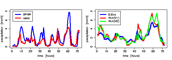
Figure 2: TVM catchment mean time series of precipitation estimated from rain gauge, radar data, and simulated with ALADIN.
Obviously, it is a difficult task to validate high-resolution simulations. Estimation of precipitation fields with rain gauge data is difficult because of low station density and measurement errors. A precipitation analysis with corrected rain gauge data for the TVM catchment (see Figs. 1, 2) is made with less than 20 gauge stations available within the catchment. The interpretation of radar data is difficult because of, e.g., ground reflectivity or shielding by mountains (as obvious in Fig. 1: The SMI Monte Lema radar position is about in the center of the shown sub-domain).
Comparison of observed mean precipitation with simulated precipitation seems to indicate that the simulations overestimate precipitation (Tab. 2). From the precipitation times series in the TVM catchment (Fig. 2) we conclude: Simulations show a precipitation peak within the period's first few hours not perceptible in the observations. The observed peaks in the period from hour 40 to hour 65 are rather well simulated. Comparing radar and rain gauge data we have to be very careful in interpretation of the temporal structure of the first three observed peaks. There is only a handful of hourly recording rain gauge stations within the catchment and their temporal measurements dominate the temporal behavior of the rain gauge analysis.
3. Hydrological simulations
The sequences of hourly accumulated precipitation fields are used as input to the distributed hydrological model WaSiM-ETH. Further, less relevant meteorological input is prescribed by observations. All meteorological input is interpolated (bi-cubic spline, height dependent inverse distance weighting) to the hydrological grid (500 m gridspacing). There has been no special calibration of WaSiM-ETH model parameters for the interesting flood event. This has been done for the 7-years period 1993 to 1999.
Tab. 2 and Fig. 3 show observed and simulated runoffs at the TVM catchment outlet. The temporal structure of simulated runoff with observed (gauge or radar data) input outperforms the runoff structure with simulated input. Obviously, there is a wrong increase of simulated runoff in the beginning of the flood period because of the erroneously forecasted precipitation peak. But, the total runoff amount is underestimated with observational input. Volume of total and peak runoff as well as timing of the flood peak is very well simulated with 9.6 km simulation input. Runoff is overestimated with 4 km input and is larger with ALADIN 4km(V2) input than with ALADIN 4km(V1) input. This directly reflects the total amount of simulated precipitation within the TVM catchment. Positioning of simulated precipitation patterns is crucial for the runoff forecast.
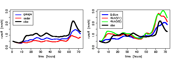
Figure 3: Observed runoff time series at TVM catchment outlet and simulated runoffs with different precipitation inputs.
|
|
obs |
gauge |
radar |
9.6km |
4km(V1) |
4km(V2) |
|
precip. [mm/h] |
|
1.78 |
1.26 |
2.35 |
2.58 |
2.71 |
|
runoff [mm/h] |
1.01 |
0.73 |
0.53 |
0.99 |
1.25 |
1.37 |
Table 2: TVM catchment and 72-h mean of precipitation and runoff rates.
4. Conclusion
First of all, we conclude that hydrological simulations are a sensible tool for validation of high-resolution precipitation fields. In case of the presented flood period the performance of 9.6 km simulations is better than of available observations in respect to total amount and maximum runoff. Because of non-linear response of runoff to precipitation, simulated runoff should improve with resolution of precipitation fields. This can not be observed because of general overestimation of precipitation with the 4 km ALADIN configurations. Possible reasons like problematic nesting strategy or moisture convergence modulation (the only difference between the 4 km configurations) have to be further investigated.
Our next step will be the investigation of additional heavy precipitation periods. This is necessary for verification that the astonishingly well performance of 9.6 km ALADIN is not accidental and to get more experience with higher resolution modeling.
5. Acknowledgements
Radar data sets are provided by the MAP Data Centre, Zürich. Further data are provided by the Swiss National Hydrological and Geological Survey and by MeteoSwiss. B.A. is supported by the Austrian Academy of Sciences, Project HÖ 22/2000. B.A. & Y.W. acknowledges help and advice from Radmila Brozkova and the ALADIN/LACE team.
6. References
Bacchi, R., Ranzi, R. (eds.) (2000). Runoff and atmospheric processes for flood hazard forecasting and control. Final Report to EC, Directorate General XII, Programme Environment and Climate 1994-1998. Contract ENV4-CT97-0552, Brussels.
Bubnova, R., Hello, G., Bernard, P., and Geleyn, J.-F. (1995). Integration of the fully elastic equations cast in the hydrostatic pressure terrain-following coordinate in the framework of the ARPEGE/Aladin NWP system. Monthly Wea. Rev., 123:515-535.
Gerard, L. (1999). Physical parameterizations in ARPEGE-ALADIN. draft version.
Jasper, K., Gurtz, J., Lang, H., Kaufmann, P., and Binder, P. (2000). Flood forecast by coupling atmospheric and hydrologic models at regional scale. In PIK Report No. 65, European Conf. on Advances in Flood Research, Proc. Vol. 1, pages 276-284.
 |
Home |