1. Introduction
MAP SOP (Mesoscale Alpine Programme - Special Observing Period) from 7 September to 15 November 1999 was divided on numbers IOP-s (Intensive Observation Periods). For the eastern part of Alps one the most interesting period is IOP5 (2 October, 06 UTC - 5 October, 06 UTC), particularly 4 October when intensive precipitation was observed. The synoptic situation was characterized by a deep trough through the whole troposphere. Its axis was tilted in SW-NE direction and strong SW winds prevailed over the middle and eastern part of the Alps. In the night from 3 - 4 October the cold front reached the MAP target area. Orographic enhanced convection was observed in relation with warm and moist air at low levels from the Adriatic Sea ahead of a relatively slow moving cold front. The process was also connected with cyclogenetical processes over the northern Italy and Adriatic Sea. On 5 October a new upper vorticity advection, crossing the alpine area, reactivated the cyclone over the Adriatic, and established northerly flow over the MAP area. Over Slovenia and Croatia the southerly moist and warm flow, connected with complex orography, enhanced the convective processes. The strongest processes took place during the 4 October morning hours. The mesoscale precipitation system from its early stage of intense and very narrow convective line developed to its later stage of widespread stratiform precipitation.
The 24-hours precipitation measured at 06 UTC on 5 October in some regions exceeded 100 mm. The largest amount of precipitation was 241 mm, measured at the station Soca in Slovenia. The second maxima can be found over western Croatia with maximum of precipitation in Slunj region (122 mm). It is noteworthy to mention that the extremes of rain amounts happened in the morning hours on 4 October (between 06 UTC and 12 UTC). At many stations the total amount of precipitation measured during that case was larger than the average monthly amount.
2. ALADIN/LACE forecasts, postprocessing and verification by HRID
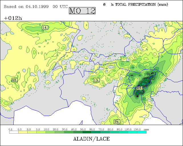
ALADIN/LACE correctly forecast this intense precipitation event. The 6-hourly precipitation produced by the model for 12 UTC, shown in Fig. 1, gives the evidence of the model good performance. Previous model run from 3 October, 00 UTC shows the similar precipitation distribution, but less in amounts. The region of maximal precipitation is well forecasted and also agrees very well with the observation.
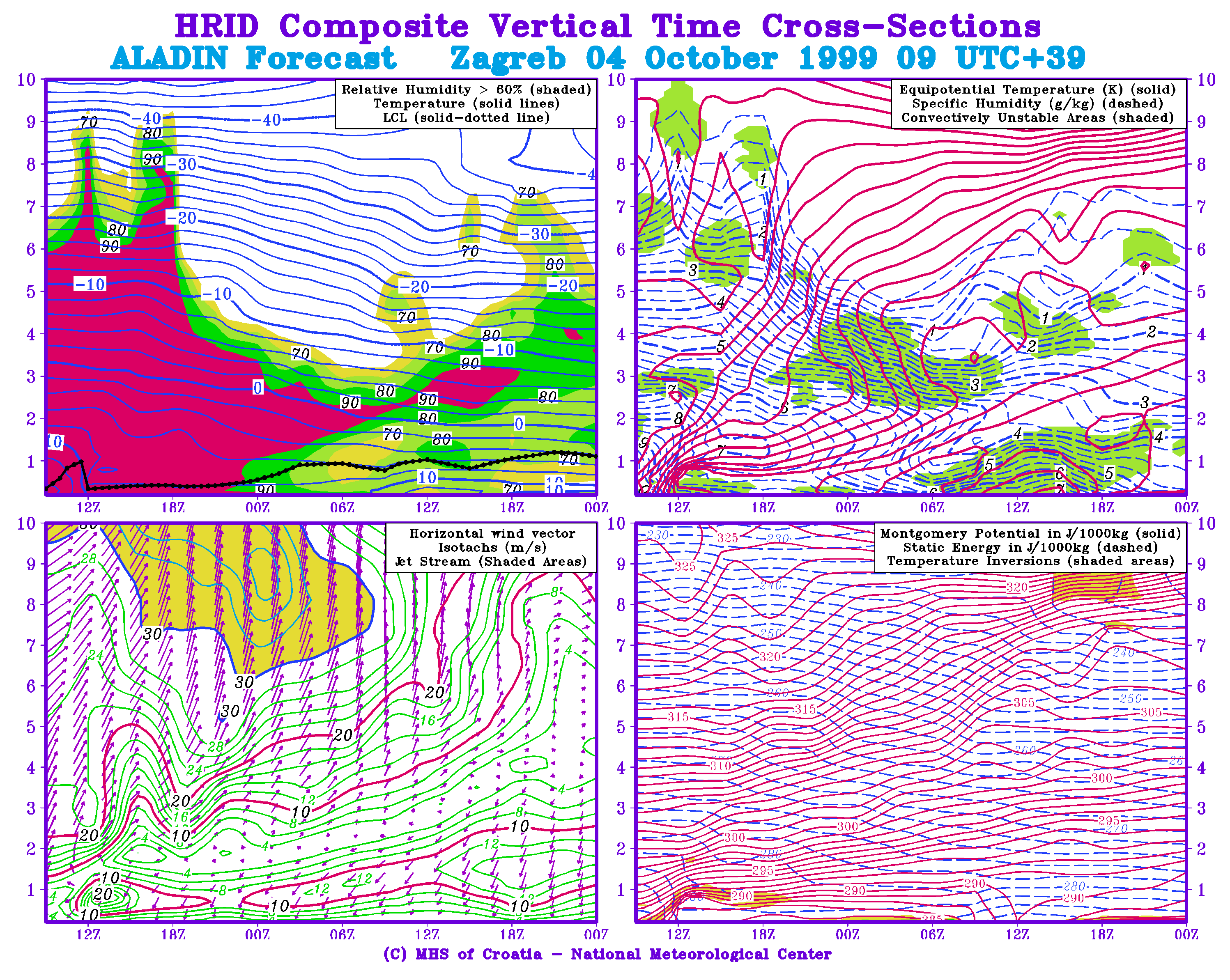
During the whole IOP5 enhanced 6-hourly (Zagreb 3-hourly) radiosonde network was establish. Fig. 2 shows a time-height cross-sections of relative humidity, temperature, equipotential temperature, specific humidity, horizontal wind, Montgomery potential and static energy from the model for Zagreb and analysis of vertical structure of the atmosphere in the same time period based on the radiosounding measurements. The model has captured the whole process of time and space variations very well. The front is well indicated by the isopleths of equipotential temperature that steeply lift up and also in the wind field. In the late afternoon on 4 October humidity content in the middle troposphere has rapidly decreased following the passage of a cold front. This process is a little late in the model forecast.
The enhancement of the frequency of radiosonde ascents in Zagreb during IOP5 and the availability of the 3-hourly radiosonde measurements gave us an exceptional opportunity to get more information on the capability of the ALADIN/LACE model to predict quite locally the vertical atmospheric structure and its time changes. The verification against observation was done here by intercomparison of the HRID vertical time cross-sections produced on the basis of both the ALADIN/LACE pseudoTEMPs and TEMP messages at every 3-hour.
An obvious similarity between analyses and prognostic time cross-sections can be recognized by their comparison in Fig.2. From the forecasters point of view the intensity, local development and lifetime of considered atmospheric system was successfully predicted. There are some differences in the wind structure and a certain delay in establishing the moist processes in the upper and middle troposphere, but they didn't have any special meaning in creating local forecast for Zagreb. In conclusion, when evaluating considered ALADIN/LACE forecast we must keep in mind that it was the forecast of an extraordinary event.
Fig. 1: ALADIN/LACE accumulated precipitation, 4 October 1999 00 UTC +12 hours.
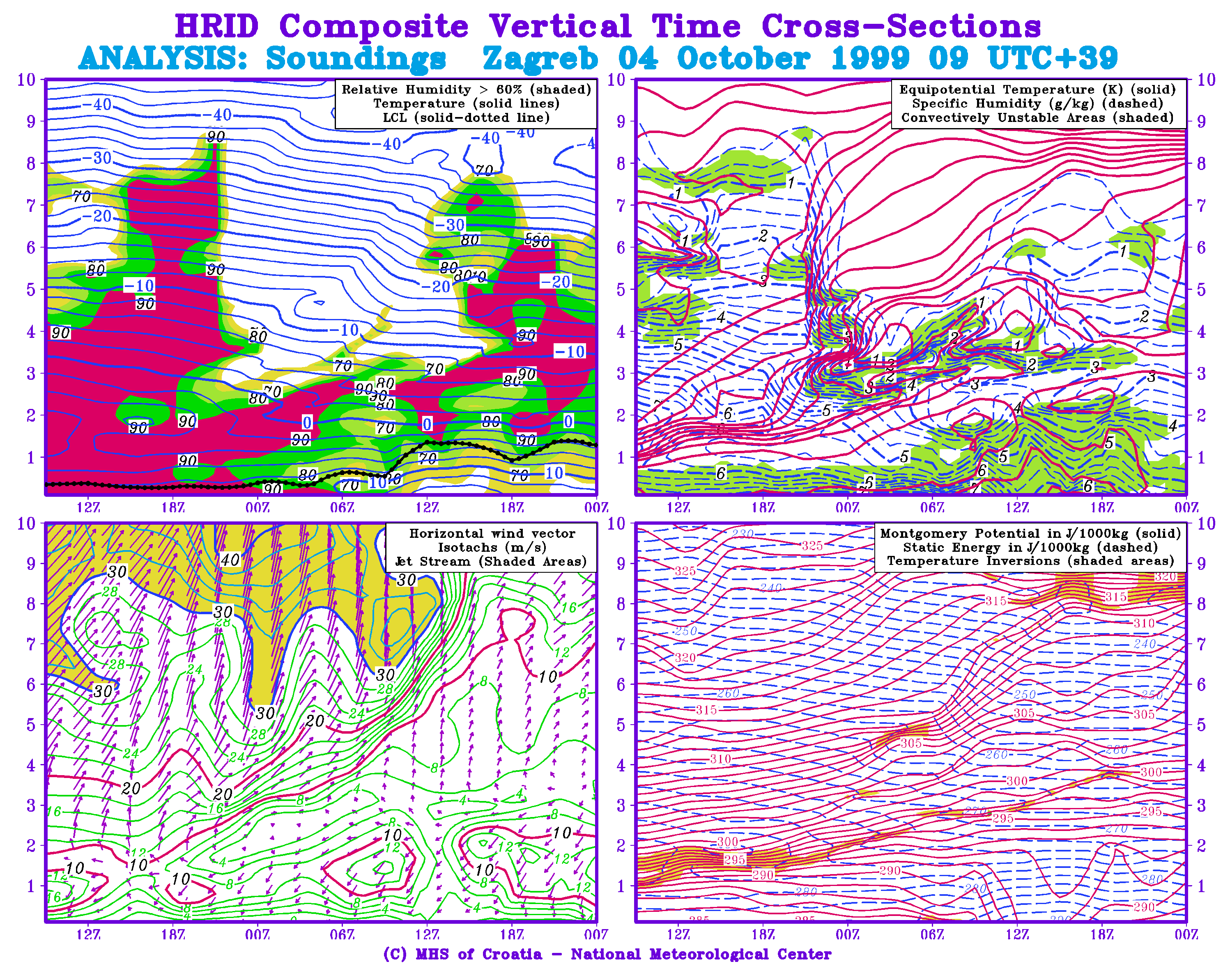
Fig. 2: Composite vertical cross-sections for Zagreb 4 October 1999, 09 UTC + 39; analysis (above) and ALADIN/LACE forecast (below)
 |
Home |