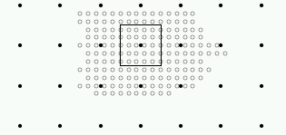
Figure 1: One example of a possible local (empty circles) and final grids (black circles) with the final grid box.
Running Aladin model with high resolution (few kilometers) needs a good description of the climate parameters at high resolution.
The orography data set used now for creating the operational climate files is a global, 2'30" orography data prepared (by E. Legrand) from a global, 30" orography data (GLOBE or GTOPO30). This resolution is sufficient for running Aladin model at grid distance greater than approximately 5 km. But with finer resolution we need better description of the orography.
The question is how to include finer orography data which usually cover only a limited area and sometimes does not cover the whole domain of the model integration. The aim of this study is to try to improve the representation of model orography using a local, finer data set, which is not necessary covering the domain of model integration and is not a complete data set.
Possibilities to include local orography data
On the basis of the discussions several possibilities arose:
a) Preparing an Aladin Orography file
File with the orography data can be included
in the step one of the e923 configuration using the key LNORO. In this
case a new orography and a new land sea mask (if asked) are used. It is
read from an Aladin file (name is neworog) and after checking the frame,
it undergoes the biperiodisation and spectral fit if grid point orography
is read. The advantage is the standard format of files (FA) but it is supposed
that the fine orography covers the whole area (however, there is a way
to avoid this).
b) Inside the code
This would be done like it is done now for the
computation of the fields using vegetation data. This possibility seems
to be complicated to implement since the local files have different format
(not FA files). After several discussions we concluded that this possibility
is improper since the e923 configuration is already quite complicated,
having several steps.
c) Outside the code
In this case first a new orography data set
with higher resolution would be created. From the local fine data and from
the operational data an intermediate, new orography data set can be created.
This possibility does not imply any changes to the Aladin code, concerning
the format of the files and it can be adapted easily in each country. This
would also give unified definition and methods when creating new data sets
between Aladin consortium partners.
Finally we decided to create a new orography data set which can be used at the first step of the configuration e923. This is a safe method and can be adapted without any changes in the ALADIN model code.
Creation of the orography data set
The basic data for creating new set are local orography data in high resolution. Since only sub-grid mean orography height is usually available and than some information about topography variability, about slopes, and about number of peaks are required the resolution of orography data set can not be the same as the local orography data. We also have to consider which data should be used in the areas of no high resolution data.
Orography data set
Files needed for the first step of the configuration e923 can be named orography data set. The following files are included:
| Oro_Mean | Mean orography Hmean (mean of H) | m |
| Oro_Max | Maximum orography Hmax (max of H) | m |
| Oro_Min | Minimum orography Hmin(min of H) | m |
| Sigma | Sub-grid standard deviation of Hmean | m |
| Nb_Peaks | Number of sub-grid peaks | |
| Hmax-HxH-Hmin_ov4 | mean of (Hmax-Hmean)(Hmean-Hmin)/4 | m2 |
| Dh_over_Dx_Dh_over_Dy | mean of dHmean/dx*dHmean/dy | m2/km2 |
| Dh_over_Dx_square | mean of (dHmean/dx)**2 | m2/km2 |
| Dh_over_Dy_square | mean of (dHmean/dy)**2 | m2/km2 |
| Water_Percentage | Land/Sea mask | % of water |
| Urbanisation | Fraction of urbanisation | % of city |
Methodology
At the beginning three kinds of grids should be defined:
Interpolation from the local to the final
grid
For each point of the final grid a box equal
to the mesh of the target grid is defined. The value in the target grid
point is computed from the values in points of local grid inside this box
(see figure 1). In boxes where there is no local value a missing value
is taken.
Figure 1: One example of a possible local (empty
circles) and final grids (black circles) with the final grid box.
- Mean height of orography in the target grid point is the average of the values of the local grid points which are inside the box.Interpolation from the basic grid to the final grid
- Sigma is the value of standard deviation of the orography height inside the box.
- Derivatives are calculated in the local points and then averaged over the points in the box.
- Inside every box of the final grid the number of peaks is calculated according to points of the local grid.
- For calculation of Hmax-HxH-Hmin_ov4 three types of data are needed for each local grid point: the orography height (H), the minimum (Hmin) and the maximum (Hmax) sub-grid heights for the point. If all data are present than for each point of local grid value of (Hmax-H)*(H-Hmin)/4 is calculated and the value in the point of target grid is the average over the local points. But usually only the height is available and in this case the values are set to missing value.
- For calculation of Water_Percentage Hmax and Hmin are also very useful. It can be supposed that there is water if Hmin and Hmax are equal to zero. If those data are not available, values in local grid should be evaluated in different way, maybe from coast lines. If local data for proportion of water are available then they are averaged inside the boxes, otherwise they are put to missing value.
- If local data for Urbanisation are available then they are averaged inside the boxes, otherwise they are put to missing value.
Merging the data into final grid
In this step all values of the final grid are
filled, which is a merge between the two results obtained from interpolation
from the basic grid to the final one and from the local to the final grid.
If there is a missing value the values issued from the basic grid are selected,
otherwise the value issued from the local data is taken.
Example
In Slovenia, data for orography height in 100
m resolution are available, but this is the case only inside the borders
(the Western part of Slovenia can be seen on figure 2). We combine these
data with the basic orography in resolution of 2'30" (see figure 3). For
presentation of results one smaller domain located around the west border
of Slovenia is chosen. The target, final resolution is 4 times better than
the basic one. The result of merging the two orographies can be seen on
the figure 4. In the area where local data are available these data are
used (more detailed topography on the figure 4), while in the other parts
the data from basic grid are used.
For selected domain there are 48x48 points in
the basic grid, and 192x192 points in the target one. So the value of one
point in basic grid is first prescribed to 16 points in the target grid.
The value of the point in the target grid where local data are available
is calculated as an average over the points inside the target box. When
local grid points cover whole target box there are 96 local grid points
inside the box.
Conclusions
To use the local orography data for the creation
of ALADIN climatological files, a procedure was developed outside the ALADIN
code. The orography data set needed for the first step of configuration
e923 can be prepared in similar way as it is now but using also available
local data. More about the program (how to use it, where it can be found)
is written in the complete version.
There are still some tests to be done regarding
creation of ALADIN climatological file at the basis of this data orography
set. There are some problems to be expected. Slopes are much steeper when
resolution of data is higher, so values in derivative fields can be very
different. The number of sub-grid peaks depends on the amount of points
inside the final box.
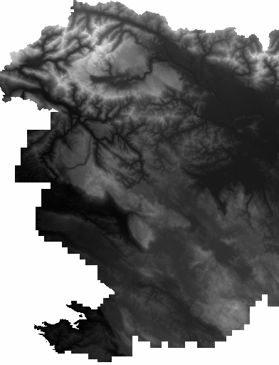
Figure 2: The orography of the Western part
of Slovenia in the local grid (resolution 100 m, 950x1240 points).
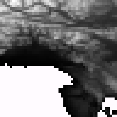
Figure 3: The orography for selected domain
in the basic grid (resolution 2'30", 48x48 points). The domain includes
the Western part of Slovenia, the Northern part of Adriatic Sea, the Istrian
peninsula the Eastern part of Italy, and a part of Southern Austria.
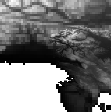
Figure 4: The orography for selected domain
in the final grid (resolution 37.5", 192x192 points).
 |
Home |